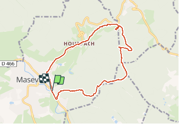
![](/images/other/stat-length.png)
![Tour Wandern Masevaux-Niederbruck - Buchberg - Photo](https://media.geolcdn.com/t/1900/400/bd30c6b6-caa3-4b4f-ab27-4be87096d268.jpg&format=pjpeg&maxdim=2)
Buchberg
helmut68
Benutzer
![Länge](/images/other/stat-length.png)
![Maximale Höhe](https://static1.geolcdn.com/siteimages/upload/files/1508320355ic_sort_altitude_max_24dp.png)
![Positive Höhendifferenz](https://static1.geolcdn.com/siteimages/upload/files/1508320355ic_sort_den_pos_24dp.png)
![Km-Effort](/images/other/stat-length.png)
![Min. Höhe](https://static1.geolcdn.com/siteimages/upload/files/1508320355ic_sort_altitude_min_24dp.png)
![Negative Höhendifferenz](https://static1.geolcdn.com/siteimages/upload/files/1508320355ic_sort_den_neg_24dp.png)
![Boucle](https://static1.geolcdn.com/siteimages/upload/files/16400158638029165_repeat_loop_refresh_sync_direction_icon.png)
![Wandern](https://static1.geolcdn.com/sitytour/trail-icons/101.png)
2h36
Schwierigkeit : Einfach
![Scannen Sie diesen QR-Code, um die Tour in der SityTrail-Anwendung zu öffnen](https://capi.geolives.com/qq0zvz2zws4bq2lad0pu/sitytour/trails/2297909/qr.png?size=200)
Kostenlosegpshiking-Anwendung
Über SityTrail
Tour Wandern von 8,5 km verfügbar auf Großer Osten, Oberelsass, Masevaux-Niederbruck. Diese Tour wird von helmut68 vorgeschlagen.
Beschreibung
Départ à la caserne des pompiers de Masevaux , suivre le marquage "triangle jaune" jusqu'au Buchberg ,ensuite le " triangle rouge" jusqu'au Schirm, puis le rectangle " rouge blanc rouge " jusqu'au retour à Masevaux.
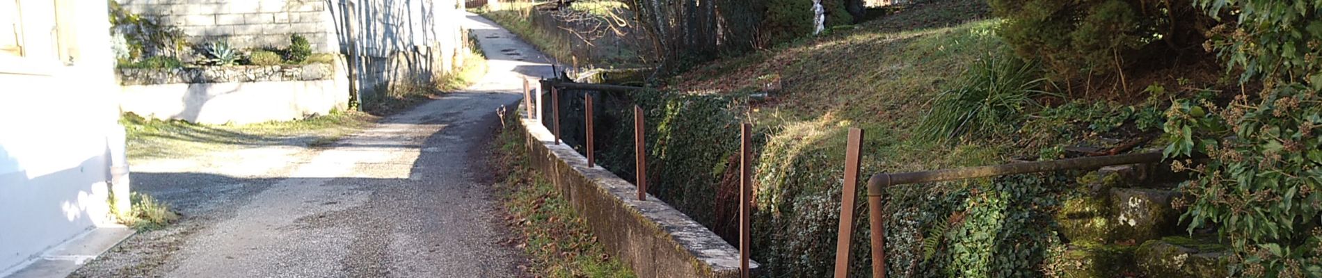
Belle petite balade ou l'on peut prendre le repas tiré du sac sur un banc au Buchberg , sinon un peu plus loin au Rocher du Poilus ( plusieurs tables ) ou au col du Schirm ( plusieurs tables) .
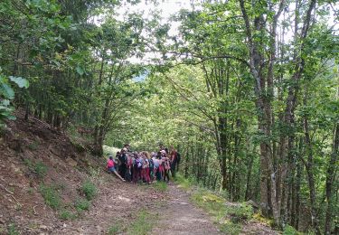
Alors à vos chaussures.....
Ort
Kommentare
Touren in der Umgebung
![Tour Wandern Masevaux-Niederbruck - Masevaux - Rossberg par le belvédère du Fuchsfelsen - Photo](https://media.geolcdn.com/t/375/260/d9cc765c-1250-4953-9d9f-fb8b88eb82a7.jpg&format=jpg&maxdim=2)
![Wandern Wandern](https://static1.geolcdn.com/sitytour/trail-icons/101.png)
Wandern
![](/images/other/stat-length.png)
![](https://static1.geolcdn.com/siteimages/upload/files/16400158638029165_repeat_loop_refresh_sync_direction_icon.png)
![Tour Wandern Sentheim - Sentheim Rossberg - Photo](https://media.geolcdn.com/t/375/260/a036ff16-f534-44a4-ad7d-39598edf8c1e.jpg&format=jpg&maxdim=2)
![Wandern Wandern](https://static1.geolcdn.com/sitytour/trail-icons/101.png)
Wandern
![](/images/other/stat-length.png)
![](https://static1.geolcdn.com/siteimages/upload/files/16400158638029165_repeat_loop_refresh_sync_direction_icon.png)
![Tour Wandern Oberburbach - 2024-01-12_14h17m14_239006910 - Photo](https://media.geolcdn.com/t/375/260/d4089ace-97e6-4d95-86a3-a999ece263d3.jpg&format=jpg&maxdim=2)
![Wandern Wandern](https://static1.geolcdn.com/sitytour/trail-icons/101.png)
Wandern
![](/images/other/stat-length.png)
![](https://static1.geolcdn.com/siteimages/upload/files/16400158638029165_repeat_loop_refresh_sync_direction_icon.png)
![Tour Wandern Au - 2022-07-14 Marche Lauw Refuge CAF Baerenkopf - Photo](https://media.geolcdn.com/t/375/260/e2209d17-65ac-46f6-a404-5274e10a843e.jpg&format=jpg&maxdim=2)
![Wandern Wandern](https://static1.geolcdn.com/sitytour/trail-icons/101.png)
Wandern
![](/images/other/stat-length.png)
![](https://static1.geolcdn.com/siteimages/upload/files/16400158638029165_repeat_loop_refresh_sync_direction_icon.png)
![Tour Zu Fuß Sentheim - Sentier géologique du Wolfloch - Photo](https://media.geolcdn.com/t/375/260/3b31644e-e98b-4e9b-958d-a3c4208c2bbd.jpeg&format=jpg&maxdim=2)
![Zu Fuß Zu Fuß](https://static1.geolcdn.com/sitytour/trail-icons/100.png)
Zu Fuß
![](/images/other/stat-length.png)
![](https://static1.geolcdn.com/siteimages/upload/files/16400158638029165_repeat_loop_refresh_sync_direction_icon.png)
![Tour Zu Fuß Sentheim - Sentheim - Bergwald - Eichwald - Guevenheim - Sentheim - Photo](https://media.geolcdn.com/t/375/260/ext.jpg?maxdim=2&url=https%3A%2F%2Fstatic1.geolcdn.com%2Fsiteimages%2Fupload%2Ffiles%2F1545311037marcheuse_200dpi.jpg)
![Zu Fuß Zu Fuß](https://static1.geolcdn.com/sitytour/trail-icons/100.png)
Zu Fuß
![](/images/other/stat-length.png)
![](https://static1.geolcdn.com/siteimages/upload/files/16400158638029165_repeat_loop_refresh_sync_direction_icon.png)
![Tour Wandern Bitschweiler - 68 Col du Hundsrück - FA Gsang - retour ThannerHubel - Photo](https://media.geolcdn.com/t/375/260/ext.jpg?maxdim=2&url=https%3A%2F%2Fstatic1.geolcdn.com%2Fsiteimages%2Fupload%2Ffiles%2F1553511878bg_sport_marche.png)
![Wandern Wandern](https://static1.geolcdn.com/sitytour/trail-icons/101.png)
Wandern
![](/images/other/stat-length.png)
![](https://static1.geolcdn.com/siteimages/upload/files/16400158638029165_repeat_loop_refresh_sync_direction_icon.png)
![Tour Wandern Masevaux-Niederbruck - Reco avec ALAIN..Rando CLAS du 29/08/2024 - Photo](https://media.geolcdn.com/t/375/260/5dba7985-af1b-4076-a275-05f9cb5145f8.jpg&format=jpg&maxdim=2)
![Wandern Wandern](https://static1.geolcdn.com/sitytour/trail-icons/101.png)
Wandern
![](/images/other/stat-length.png)
![](https://static1.geolcdn.com/siteimages/upload/files/16400158638029165_repeat_loop_refresh_sync_direction_icon.png)
![Tour Wandern Wegscheid - Sortie école primaire - Rossberg - Photo](https://media.geolcdn.com/t/375/260/5c043488-0fe8-43df-9af8-c7309c0507d8.jpg&format=jpg&maxdim=2)
![Wandern Wandern](https://static1.geolcdn.com/sitytour/trail-icons/101.png)
Wandern
![](/images/other/stat-length.png)
![](https://static1.geolcdn.com/siteimages/upload/files/16400158638029165_repeat_loop_refresh_sync_direction_icon.png)