![](/images/other/stat-length.png)
![Tour Wandern Nizza - Vieux Nice-St Jean Cap Ferrat-Vieux Nice - Photo](https://media.geolcdn.com/t/1900/400/ext.pjpeg?maxdim=2&url=https%3A%2F%2Fstatic1.geolcdn.com%2Fsiteimages%2Fupload%2Ffiles%2F1553511878bg_sport_marche.png)
Vieux Nice-St Jean Cap Ferrat-Vieux Nice
coriace
Benutzer
![Länge](/images/other/stat-length.png)
Länge
31 km
![Maximale Höhe](https://static1.geolcdn.com/siteimages/upload/files/1508320355ic_sort_altitude_max_24dp.png)
Maximale Höhe
90 m
![Positive Höhendifferenz](https://static1.geolcdn.com/siteimages/upload/files/1508320355ic_sort_den_pos_24dp.png)
Positive Höhendifferenz
593 m
![Km-Effort](/images/other/stat-length.png)
Km-Effort
38 km
![Min. Höhe](https://static1.geolcdn.com/siteimages/upload/files/1508320355ic_sort_altitude_min_24dp.png)
Min. Höhe
-1 m
![Negative Höhendifferenz](https://static1.geolcdn.com/siteimages/upload/files/1508320355ic_sort_den_neg_24dp.png)
Negative Höhendifferenz
576 m
![Boucle](https://static1.geolcdn.com/siteimages/upload/files/16400158638029165_repeat_loop_refresh_sync_direction_icon.png)
Boucle
Nein
Erstellungsdatum :
2019-12-28 12:18:55.974
Letzte Änderung :
2019-12-29 15:44:44.818
![Wandern](https://static1.geolcdn.com/sitytour/trail-icons/101.png)
4h14
Schwierigkeit : Sehr leicht
![Scannen Sie diesen QR-Code, um die Tour in der SityTrail-Anwendung zu öffnen](https://capi.geolives.com/qq0zvz2zws4bq2lad0pu/sitytour/trails/2292696/qr.png?size=200)
Kostenlosegpshiking-Anwendung
Über SityTrail
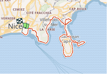
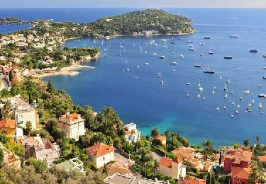
Tour Wandern von 31 km verfügbar auf Provence-Alpes-Côte d'Azur, Seealpen, Nizza. Diese Tour wird von coriace vorgeschlagen.
Beschreibung
Départ vieux Nice à pied. Prendre bus du port de Nice. Arrêt Passable/Rotschild. Marche bord du littoral (kms). Prendre bus port de st Jean jusqu'à place Garibaldi. soit 20 kms en bus aller-retour et 10 kms de marche au total.
Ort
Land:
France
Region :
Provence-Alpes-Côte d'Azur
Abteilung/Provinz :
Seealpen
Kommune :
Nizza
Standort:
Unknown
Gehen Sie:(Dec)
Gehen Sie:(UTM)
361117 ; 4839483 (32T) N.
Kommentare
Touren in der Umgebung
![Tour Wandern Nizza - Ballade chemin des douaniers Nice-Villefranche - Photo](https://media.geolcdn.com/t/375/260/c2d5ab1c-da60-4999-9c1c-1e8798e5ba02.jpg&format=jpg&maxdim=2)
![Wandern Wandern](https://static1.geolcdn.com/sitytour/trail-icons/101.png)
Ballade chemin des douaniers Nice-Villefranche
Wandern
Sehr leicht
(1)
Nizza,
Provence-Alpes-Côte d'Azur,
Seealpen,
France
![](/images/other/stat-length.png)
7,9 km | 10,3 km-effort
2h 13min
![](https://static1.geolcdn.com/siteimages/upload/files/16400158638029165_repeat_loop_refresh_sync_direction_icon.png)
Nein
![Tour Wandern Nizza - Collines niçoises - Photo](https://media.geolcdn.com/t/375/260/ext.jpg?maxdim=2&url=https%3A%2F%2Fservices.sitytrail.com%2FGeolivesWS%2FDownloadMedia.ashx%3FTrailID%3D337283%26Media%3D20140820134937.jpg)
![Wandern Wandern](https://static1.geolcdn.com/sitytour/trail-icons/101.png)
Collines niçoises
Wandern
Einfach
(1)
Nizza,
Provence-Alpes-Côte d'Azur,
Seealpen,
France
![](/images/other/stat-length.png)
21 km | 30 km-effort
6h 32min
![](https://static1.geolcdn.com/siteimages/upload/files/16400158638029165_repeat_loop_refresh_sync_direction_icon.png)
Nein
![Tour Wandern Saint-Jean-Cap-Ferrat - Cap Ferrat 2011-10-27 - Photo](https://media.geolcdn.com/t/375/260/ext.jpg?maxdim=2&url=https%3A%2F%2Fservices.sitytrail.com%2FGeolivesWS%2FDownloadMedia.ashx%3FTrailID%3D89946%26Media%3D20111027142707.jpeg)
![Wandern Wandern](https://static1.geolcdn.com/sitytour/trail-icons/101.png)
Cap Ferrat 2011-10-27
Wandern
Medium
(2)
Saint-Jean-Cap-Ferrat,
Provence-Alpes-Côte d'Azur,
Seealpen,
France
![](/images/other/stat-length.png)
10,9 km | 14 km-effort
4h 0min
![](https://static1.geolcdn.com/siteimages/upload/files/16400158638029165_repeat_loop_refresh_sync_direction_icon.png)
Ja
![Tour Wandern Saint-Jean-Cap-Ferrat - Tour du Cap Ferrat - Photo](https://media.geolcdn.com/t/375/260/ext.jpg?maxdim=2&url=https%3A%2F%2Fservices.sitytrail.com%2FGeolivesWS%2FDownloadMedia.ashx%3FTrailID%3D435405%26Media%3Dfix__20150613163217.jpg)
![Wandern Wandern](https://static1.geolcdn.com/sitytour/trail-icons/101.png)
Tour du Cap Ferrat
Wandern
Einfach
Saint-Jean-Cap-Ferrat,
Provence-Alpes-Côte d'Azur,
Seealpen,
France
![](/images/other/stat-length.png)
7,1 km | 9,4 km-effort
1h 40min
![](https://static1.geolcdn.com/siteimages/upload/files/16400158638029165_repeat_loop_refresh_sync_direction_icon.png)
Ja
![Tour Wandern Saint-Jean-Cap-Ferrat - w-frankrijk-tour-du-cap-ferrat - Photo](https://media.geolcdn.com/t/375/260/ext.jpg?maxdim=2&url=https%3A%2F%2Fstatic1.geolcdn.com%2Fsiteimages%2Fupload%2Ffiles%2F1553511878bg_sport_marche.png)
![Wandern Wandern](https://static1.geolcdn.com/sitytour/trail-icons/101.png)
w-frankrijk-tour-du-cap-ferrat
Wandern
Sehr leicht
(1)
Saint-Jean-Cap-Ferrat,
Provence-Alpes-Côte d'Azur,
Seealpen,
France
![](/images/other/stat-length.png)
6,5 km | 8,6 km-effort
Unbekannt
![](https://static1.geolcdn.com/siteimages/upload/files/16400158638029165_repeat_loop_refresh_sync_direction_icon.png)
Nein
![Tour Wandern Saint-Jean-Cap-Ferrat - Tour du Cap Ferrat - Photo](https://media.geolcdn.com/t/375/260/ext.jpg?maxdim=2&url=https%3A%2F%2Fservices.sitytrail.com%2FGeolivesWS%2FDownloadMedia.ashx%3FTrailID%3D105209%26Media%3D8849_1.jpg)
![Wandern Wandern](https://static1.geolcdn.com/sitytour/trail-icons/101.png)
Tour du Cap Ferrat
Wandern
Medium
(4)
Saint-Jean-Cap-Ferrat,
Provence-Alpes-Côte d'Azur,
Seealpen,
France
![](/images/other/stat-length.png)
8,9 km | 11,2 km-effort
2h 0min
![](https://static1.geolcdn.com/siteimages/upload/files/16400158638029165_repeat_loop_refresh_sync_direction_icon.png)
Ja
![Tour Wandern Villefranche-sur-Mer - Balcons de Beaulieu 11.1.24 - Photo](https://media.geolcdn.com/t/375/260/b25ef240-7e5d-488d-86bf-1cb2f63b1b2e.jpg&format=jpg&maxdim=2)
![Wandern Wandern](https://static1.geolcdn.com/sitytour/trail-icons/101.png)
Balcons de Beaulieu 11.1.24
Wandern
Medium
Villefranche-sur-Mer,
Provence-Alpes-Côte d'Azur,
Seealpen,
France
![](/images/other/stat-length.png)
8 km | 13,7 km-effort
2h 30min
![](https://static1.geolcdn.com/siteimages/upload/files/16400158638029165_repeat_loop_refresh_sync_direction_icon.png)
Ja
![Tour Wandern Saint-Jean-Cap-Ferrat - Le tour de la Presqu'ile de St Jean Cap Ferrat - Photo](https://media.geolcdn.com/t/375/260/701cf7de-4cfa-4004-9aea-c2fa39fa0153.jpeg&format=jpg&maxdim=2)
![Wandern Wandern](https://static1.geolcdn.com/sitytour/trail-icons/101.png)
Le tour de la Presqu'ile de St Jean Cap Ferrat
Wandern
Einfach
Saint-Jean-Cap-Ferrat,
Provence-Alpes-Côte d'Azur,
Seealpen,
France
![](/images/other/stat-length.png)
10,9 km | 13,7 km-effort
3h 7min
![](https://static1.geolcdn.com/siteimages/upload/files/16400158638029165_repeat_loop_refresh_sync_direction_icon.png)
Ja
![Tour Wandern Nizza - Nice cathédrale Russe - Photo](https://media.geolcdn.com/t/375/260/a2805ec0-0633-4ac1-93e3-767707679f1d.jpg&format=jpg&maxdim=2)
![Wandern Wandern](https://static1.geolcdn.com/sitytour/trail-icons/101.png)
Nice cathédrale Russe
Wandern
Sehr leicht
Nizza,
Provence-Alpes-Côte d'Azur,
Seealpen,
France
![](/images/other/stat-length.png)
6,9 km | 7,8 km-effort
2h 10min
![](https://static1.geolcdn.com/siteimages/upload/files/16400158638029165_repeat_loop_refresh_sync_direction_icon.png)
Ja