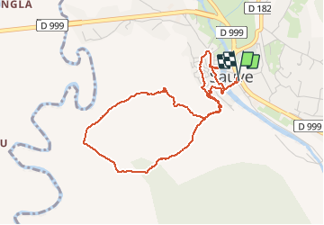
![](/images/other/stat-length.png)
![Tour Wandern Sauve - Sauve - Mer des rochers - Photo](https://media.geolcdn.com/t/1900/400/dc5d0495-41b1-4045-907b-e46f9c00f109.jpg&format=pjpeg&maxdim=2)
Sauve - Mer des rochers
campingmasdelacam
Benutzer
![Länge](/images/other/stat-length.png)
Länge
4,9 km
![Maximale Höhe](https://static1.geolcdn.com/siteimages/upload/files/1508320355ic_sort_altitude_max_24dp.png)
Maximale Höhe
154 m
![Positive Höhendifferenz](https://static1.geolcdn.com/siteimages/upload/files/1508320355ic_sort_den_pos_24dp.png)
Positive Höhendifferenz
88 m
![Km-Effort](/images/other/stat-length.png)
Km-Effort
6 km
![Min. Höhe](https://static1.geolcdn.com/siteimages/upload/files/1508320355ic_sort_altitude_min_24dp.png)
Min. Höhe
96 m
![Negative Höhendifferenz](https://static1.geolcdn.com/siteimages/upload/files/1508320355ic_sort_den_neg_24dp.png)
Negative Höhendifferenz
88 m
![Boucle](https://static1.geolcdn.com/siteimages/upload/files/16400158638029165_repeat_loop_refresh_sync_direction_icon.png)
Boucle
Ja
Erstellungsdatum :
2019-12-28 12:35:12.0
Letzte Änderung :
2019-12-29 09:41:30.419
![Wandern](https://static1.geolcdn.com/sitytour/trail-icons/101.png)
1h30
Schwierigkeit : Unbekannt
![Scannen Sie diesen QR-Code, um die Tour in der SityTrail-Anwendung zu öffnen](https://capi.geolives.com/qq0zvz2zws4bq2lad0pu/sitytour/trails/2291788/qr.png?size=200)
Kostenlosegpshiking-Anwendung
Über SityTrail
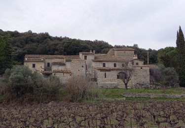
Tour Wandern von 4,9 km verfügbar auf Okzitanien, Gard, Sauve. Diese Tour wird von campingmasdelacam vorgeschlagen.
Beschreibung
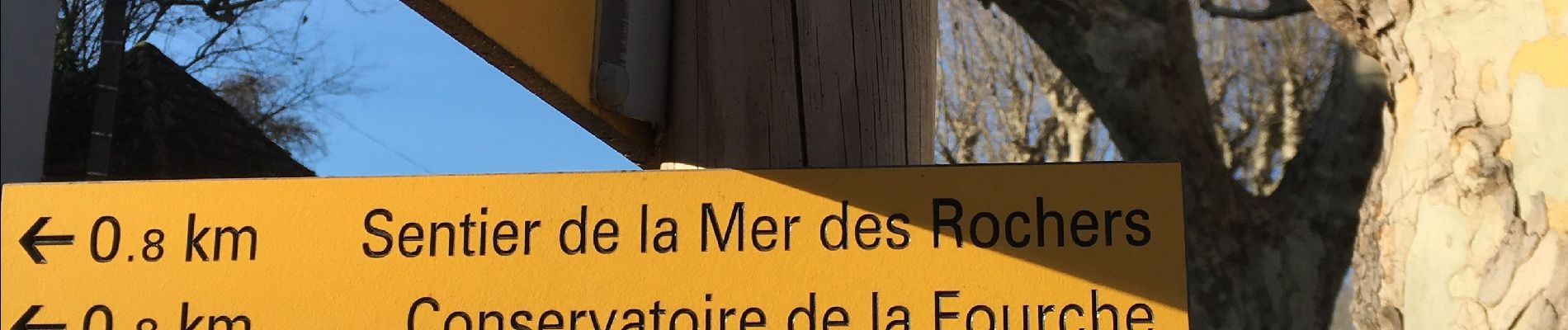
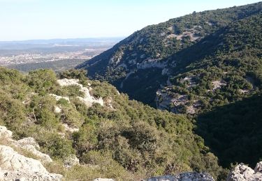
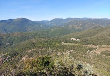
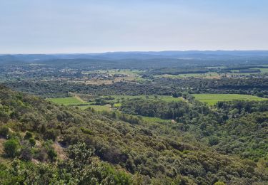
Peu de dénivelé, dans les bois de chênes, belle vue sur la mer des rochers, le tour de Sauve en fin de parcours est intéresssant !
Ort
Land:
France
Region :
Okzitanien
Abteilung/Provinz :
Gard
Kommune :
Sauve
Standort:
Unknown
Gehen Sie:(Dec)
Gehen Sie:(UTM)
576392 ; 4865690 (31T) N.
Kommentare
Touren in der Umgebung
![Tour Wandern Quissac - Quissac - Photo](https://media.geolcdn.com/t/375/260/ext.jpg?maxdim=2&url=https%3A%2F%2Fservices.sitytrail.com%2FGeolivesWS%2FDownloadMedia.ashx%3FTrailID%3D233243%26Media%3Dfix__20131117121007.jpg)
![Wandern Wandern](https://static1.geolcdn.com/sitytour/trail-icons/101.png)
![Tour Zu Fuß Liouc - Les chênes de Coutach - Photo](https://media.geolcdn.com/t/375/260/cf45b531-3715-4133-ba5a-b053d48b9be2.jpeg&format=jpg&maxdim=2)
![Zu Fuß Zu Fuß](https://static1.geolcdn.com/sitytour/trail-icons/100.png)
Les chênes de Coutach
Zu Fuß
Einfach
Liouc,
Okzitanien,
Gard,
France
![](/images/other/stat-length.png)
6,7 km | 10,6 km-effort
2h 24min
![](https://static1.geolcdn.com/siteimages/upload/files/16400158638029165_repeat_loop_refresh_sync_direction_icon.png)
Nein
![Tour Wandern Sauve - Chateau de Freissac / le Crespou - Photo](https://media.geolcdn.com/t/375/260/7c638cf8-dd40-4fbf-83bf-0016c1c94c8e.jpg&format=jpg&maxdim=2)
![Wandern Wandern](https://static1.geolcdn.com/sitytour/trail-icons/101.png)
Chateau de Freissac / le Crespou
Wandern
Medium
Sauve,
Okzitanien,
Gard,
France
![](/images/other/stat-length.png)
16,8 km | 23 km-effort
5h 40min
![](https://static1.geolcdn.com/siteimages/upload/files/16400158638029165_repeat_loop_refresh_sync_direction_icon.png)
Ja
![Tour Wandern Sauve - Sauve, le sentier de l'Aven - Photo](https://media.geolcdn.com/t/375/260/ext.jpg?maxdim=2&url=https%3A%2F%2Fstatic1.geolcdn.com%2Fsiteimages%2Fupload%2Ffiles%2F1553511878bg_sport_marche.png)
![Wandern Wandern](https://static1.geolcdn.com/sitytour/trail-icons/101.png)
Sauve, le sentier de l'Aven
Wandern
Einfach
(1)
Sauve,
Okzitanien,
Gard,
France
![](/images/other/stat-length.png)
4,2 km | 5,4 km-effort
1h 30min
![](https://static1.geolcdn.com/siteimages/upload/files/16400158638029165_repeat_loop_refresh_sync_direction_icon.png)
Ja
![Tour Elektrofahrrad Quissac - 52 Km avec 429 de dénivelé - Photo](https://media.geolcdn.com/t/375/260/ext.jpg?maxdim=2&url=https%3A%2F%2Fstatic1.geolcdn.com%2Fsiteimages%2Fupload%2Ffiles%2F1524743154velo.jpg)
![Elektrofahrrad Elektrofahrrad](https://static1.geolcdn.com/sitytour/trail-icons/205.png)
52 Km avec 429 de dénivelé
Elektrofahrrad
Einfach
(1)
Quissac,
Okzitanien,
Gard,
France
![](/images/other/stat-length.png)
52 km | 62 km-effort
2h 30min
![](https://static1.geolcdn.com/siteimages/upload/files/16400158638029165_repeat_loop_refresh_sync_direction_icon.png)
Ja
![Tour Wandern Quissac - quissac domaine de la rouviere - Photo](https://media.geolcdn.com/t/375/260/8e50166c-0651-4f06-bfd7-2016f8a1c055.jpg&format=jpg&maxdim=2)
![Wandern Wandern](https://static1.geolcdn.com/sitytour/trail-icons/101.png)
quissac domaine de la rouviere
Wandern
Einfach
Quissac,
Okzitanien,
Gard,
France
![](/images/other/stat-length.png)
19,2 km | 23 km-effort
5h 6min
![](https://static1.geolcdn.com/siteimages/upload/files/16400158638029165_repeat_loop_refresh_sync_direction_icon.png)
Ja
![Tour Wandern Conqueyrac - les 2 jumelles près de St hippolythe - Photo](https://media.geolcdn.com/t/375/260/9cbcc03d-0a76-4d68-85e5-d108525f8703.jpg&format=jpg&maxdim=2)
![Wandern Wandern](https://static1.geolcdn.com/sitytour/trail-icons/101.png)
les 2 jumelles près de St hippolythe
Wandern
Medium
Conqueyrac,
Okzitanien,
Gard,
France
![](/images/other/stat-length.png)
17,5 km | 25 km-effort
6h 3min
![](https://static1.geolcdn.com/siteimages/upload/files/16400158638029165_repeat_loop_refresh_sync_direction_icon.png)
Ja
![Tour Wandern Sauve - Sauve-Quissac-Vidourle - Photo](https://media.geolcdn.com/t/375/260/fd1a92a4-90ce-453a-8525-cca28d36a7d3.jpg&format=jpg&maxdim=2)
![Wandern Wandern](https://static1.geolcdn.com/sitytour/trail-icons/101.png)
Sauve-Quissac-Vidourle
Wandern
Schwierig
Sauve,
Okzitanien,
Gard,
France
![](/images/other/stat-length.png)
22 km | 30 km-effort
6h 49min
![](https://static1.geolcdn.com/siteimages/upload/files/16400158638029165_repeat_loop_refresh_sync_direction_icon.png)
Ja
![Tour Pfad Sauve - Sauve - Photo](https://media.geolcdn.com/t/375/260/ext.jpg?maxdim=2&url=https%3A%2F%2Fstatic1.geolcdn.com%2Fsiteimages%2Fupload%2Ffiles%2F1524743154running.jpg)
![Pfad Pfad](https://static1.geolcdn.com/sitytour/trail-icons/104.png)