![](/images/other/stat-length.png)
![Tour Wandern Guermantes - guermantes - Photo](https://media.geolcdn.com/t/1900/400/ext.pjpeg?maxdim=2&url=https%3A%2F%2Fstatic1.geolcdn.com%2Fsiteimages%2Fupload%2Ffiles%2F1553511878bg_sport_marche.png)
guermantes
vitius
Benutzer
![Länge](/images/other/stat-length.png)
Länge
11,1 km
![Maximale Höhe](https://static1.geolcdn.com/siteimages/upload/files/1508320355ic_sort_altitude_max_24dp.png)
Maximale Höhe
124 m
![Positive Höhendifferenz](https://static1.geolcdn.com/siteimages/upload/files/1508320355ic_sort_den_pos_24dp.png)
Positive Höhendifferenz
107 m
![Km-Effort](/images/other/stat-length.png)
Km-Effort
12,5 km
![Min. Höhe](https://static1.geolcdn.com/siteimages/upload/files/1508320355ic_sort_altitude_min_24dp.png)
Min. Höhe
75 m
![Negative Höhendifferenz](https://static1.geolcdn.com/siteimages/upload/files/1508320355ic_sort_den_neg_24dp.png)
Negative Höhendifferenz
108 m
![Boucle](https://static1.geolcdn.com/siteimages/upload/files/16400158638029165_repeat_loop_refresh_sync_direction_icon.png)
Boucle
Ja
Erstellungsdatum :
2019-12-14 21:34:33.978
Letzte Änderung :
2019-12-15 20:55:12.739
![Wandern](https://static1.geolcdn.com/sitytour/trail-icons/101.png)
2h48
Schwierigkeit : Schwierig
![Scannen Sie diesen QR-Code, um die Tour in der SityTrail-Anwendung zu öffnen](https://capi.geolives.com/qq0zvz2zws4bq2lad0pu/sitytour/trails/2284856/qr.png?size=200)
Kostenlosegpshiking-Anwendung
Über SityTrail
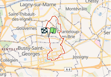
Tour Wandern von 11,1 km verfügbar auf Île-de-France, Seine-et-Marne, Guermantes. Diese Tour wird von vitius vorgeschlagen.
Beschreibung
randonnée, relativement facile, aller et retour à Guermantes en passant par Conches-sur-Gondoire et Chanteloup-en-Brie
Ort
Land:
France
Region :
Île-de-France
Abteilung/Provinz :
Seine-et-Marne
Kommune :
Guermantes
Standort:
Unknown
Gehen Sie:(Dec)
Gehen Sie:(UTM)
479306 ; 5411165 (31U) N.
Kommentare
Touren in der Umgebung
![Wandern Wandern](https://static1.geolcdn.com/sitytour/trail-icons/101.png)
Du Parc de Rentilly au Ru de la Gondoire
Wandern
Schwierig
(1)
Saint-Thibault-des-Vignes,
Île-de-France,
Seine-et-Marne,
France
![](/images/other/stat-length.png)
21 km | 24 km-effort
5h 20min
![](https://static1.geolcdn.com/siteimages/upload/files/16400158638029165_repeat_loop_refresh_sync_direction_icon.png)
Ja
![Tour Wandern Dampmart - SM_DAMPMART-EST_8.1Km - Photo](https://media.geolcdn.com/t/375/260/6a085e8e-078f-48e9-8394-a9f3cb910770.jpg&format=jpg&maxdim=2)
![Wandern Wandern](https://static1.geolcdn.com/sitytour/trail-icons/101.png)
SM_DAMPMART-EST_8.1Km
Wandern
Medium
(3)
Dampmart,
Île-de-France,
Seine-et-Marne,
France
![](/images/other/stat-length.png)
8,1 km | 9,5 km-effort
2h 9min
![](https://static1.geolcdn.com/siteimages/upload/files/16400158638029165_repeat_loop_refresh_sync_direction_icon.png)
Ja
![Tour Wandern Bussy-Saint-Georges - Boucle Rentilly - Noisiel - Etang de la Brosse - Etang de la Loy - Photo](https://media.geolcdn.com/t/375/260/2ae0fdb4-e8bd-41dd-b6e1-a0c5cc184bfe.jpg&format=jpg&maxdim=2)
![Wandern Wandern](https://static1.geolcdn.com/sitytour/trail-icons/101.png)
Boucle Rentilly - Noisiel - Etang de la Brosse - Etang de la Loy
Wandern
Sehr schwierig
Bussy-Saint-Georges,
Île-de-France,
Seine-et-Marne,
France
![](/images/other/stat-length.png)
25 km | 29 km-effort
6h 32min
![](https://static1.geolcdn.com/siteimages/upload/files/16400158638029165_repeat_loop_refresh_sync_direction_icon.png)
Ja
![Tour Wandern Dampmart - ASAM Dampmart La Dhuys - Photo](https://media.geolcdn.com/t/375/260/ext.jpg?maxdim=2&url=https%3A%2F%2Fstatic1.geolcdn.com%2Fsiteimages%2Fupload%2Ffiles%2F1553511878bg_sport_marche.png)
![Wandern Wandern](https://static1.geolcdn.com/sitytour/trail-icons/101.png)
ASAM Dampmart La Dhuys
Wandern
Einfach
(1)
Dampmart,
Île-de-France,
Seine-et-Marne,
France
![](/images/other/stat-length.png)
4,5 km | 5,4 km-effort
1h 13min
![](https://static1.geolcdn.com/siteimages/upload/files/16400158638029165_repeat_loop_refresh_sync_direction_icon.png)
Ja
![Tour Wandern Dampmart - Boucle 23 km Dampmart Annet sur Marne Base de Jabeline - Photo](https://media.geolcdn.com/t/375/260/b5b3d0bd-39cc-46d3-b0d4-bbe25a7dde4e.jpg&format=jpg&maxdim=2)
![Wandern Wandern](https://static1.geolcdn.com/sitytour/trail-icons/101.png)
Boucle 23 km Dampmart Annet sur Marne Base de Jabeline
Wandern
Medium
Dampmart,
Île-de-France,
Seine-et-Marne,
France
![](/images/other/stat-length.png)
23 km | 27 km-effort
5h 11min
![](https://static1.geolcdn.com/siteimages/upload/files/16400158638029165_repeat_loop_refresh_sync_direction_icon.png)
Ja
![Tour Wandern Dampmart - Boucle autour de Dampmart - Photo](https://media.geolcdn.com/t/375/260/5feb6ded-9010-40ac-8591-20a068c0f9dc.jpg&format=jpg&maxdim=2)
![Wandern Wandern](https://static1.geolcdn.com/sitytour/trail-icons/101.png)
Boucle autour de Dampmart
Wandern
Medium
Dampmart,
Île-de-France,
Seine-et-Marne,
France
![](/images/other/stat-length.png)
22 km | 25 km-effort
6h 24min
![](https://static1.geolcdn.com/siteimages/upload/files/16400158638029165_repeat_loop_refresh_sync_direction_icon.png)
Ja
![Tour Wandern Saint-Thibault-des-Vignes - Du Parc de Rentilly au Vallon de la Brosse - Photo](https://media.geolcdn.com/t/375/260/ext.jpg?maxdim=2&url=https%3A%2F%2Fstatic1.geolcdn.com%2Fsiteimages%2Fupload%2Ffiles%2F1553511878bg_sport_marche.png)
![Wandern Wandern](https://static1.geolcdn.com/sitytour/trail-icons/101.png)
Du Parc de Rentilly au Vallon de la Brosse
Wandern
Medium
(4)
Saint-Thibault-des-Vignes,
Île-de-France,
Seine-et-Marne,
France
![](/images/other/stat-length.png)
9,8 km | 11,3 km-effort
2h 33min
![](https://static1.geolcdn.com/siteimages/upload/files/16400158638029165_repeat_loop_refresh_sync_direction_icon.png)
Ja
![Tour Zu Fuß Bussy-Saint-Georges - Du Parc de Rentilly au Vallon de la Brosse - Photo](https://media.geolcdn.com/t/375/260/ext.jpg?maxdim=2&url=https%3A%2F%2Fstatic1.geolcdn.com%2Fsiteimages%2Fupload%2Ffiles%2F1545311037marcheuse_200dpi.jpg)
![Zu Fuß Zu Fuß](https://static1.geolcdn.com/sitytour/trail-icons/100.png)
Du Parc de Rentilly au Vallon de la Brosse
Zu Fuß
Einfach
(1)
Bussy-Saint-Georges,
Île-de-France,
Seine-et-Marne,
France
![](/images/other/stat-length.png)
7,5 km | 8,8 km-effort
1h 59min
![](https://static1.geolcdn.com/siteimages/upload/files/16400158638029165_repeat_loop_refresh_sync_direction_icon.png)
Ja
![Tour Wandern Dampmart - Dampmart Grand Parcours - Photo](https://media.geolcdn.com/t/375/260/ext.jpg?maxdim=2&url=https%3A%2F%2Fstatic1.geolcdn.com%2Fsiteimages%2Fupload%2Ffiles%2F1553511878bg_sport_marche.png)
![Wandern Wandern](https://static1.geolcdn.com/sitytour/trail-icons/101.png)
Dampmart Grand Parcours
Wandern
Einfach
(1)
Dampmart,
Île-de-France,
Seine-et-Marne,
France
![](/images/other/stat-length.png)
19,5 km | 24 km-effort
5h 9min
![](https://static1.geolcdn.com/siteimages/upload/files/16400158638029165_repeat_loop_refresh_sync_direction_icon.png)
Ja