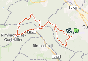
![](/images/other/stat-length.png)
![Tour Wandern Gebweiler - 5530264-Rimbach près Guebwiller - Photo](https://media.geolcdn.com/t/1900/400/ext.pjpeg?maxdim=2&url=https%3A%2F%2Fstatic1.geolcdn.com%2Fsiteimages%2Fupload%2Ffiles%2F1553511878bg_sport_marche.png)
5530264-Rimbach près Guebwiller
E.BURCK
Benutzer
![Länge](/images/other/stat-length.png)
![Maximale Höhe](https://static1.geolcdn.com/siteimages/upload/files/1508320355ic_sort_altitude_max_24dp.png)
![Positive Höhendifferenz](https://static1.geolcdn.com/siteimages/upload/files/1508320355ic_sort_den_pos_24dp.png)
![Km-Effort](/images/other/stat-length.png)
![Min. Höhe](https://static1.geolcdn.com/siteimages/upload/files/1508320355ic_sort_altitude_min_24dp.png)
![Negative Höhendifferenz](https://static1.geolcdn.com/siteimages/upload/files/1508320355ic_sort_den_neg_24dp.png)
![Boucle](https://static1.geolcdn.com/siteimages/upload/files/16400158638029165_repeat_loop_refresh_sync_direction_icon.png)
![Wandern](https://static1.geolcdn.com/sitytour/trail-icons/101.png)
3h10
Schwierigkeit : Schwierig
![Scannen Sie diesen QR-Code, um die Tour in der SityTrail-Anwendung zu öffnen](https://capi.geolives.com/qq0zvz2zws4bq2lad0pu/sitytour/trails/2284724/qr.png?size=200)
Kostenlosegpshiking-Anwendung
Über SityTrail
Tour Wandern von 10,3 km verfügbar auf Großer Osten, Oberelsass, Gebweiler. Diese Tour wird von E.BURCK vorgeschlagen.
Beschreibung
Une balade facile pour ceux qui veulent marcher avant et/ou après le repas de Noël. 330 m de dénivelé et 10 km.
ACCÈS :
- à Guebwiller prendre la rue du Vieil Armand vers le Lycée Kastler puis la rue du Sudel vers le parcours de santé.
PARKING :
-parking du parcours de santé de Guebwiller.
47.9049953, 7.1970504 ou
N 47°54'18.0", E 07°11'49.2"
RESTAURATION :
Restaurant à l'Aigle d'Or, chez Marck à Rimbach.
Tél: 03 89 76 89 90
Ort
Kommentare
Touren in der Umgebung
![Tour Mountainbike Gebweiler - P4 Circuits du Florival 2021 - Photo](https://media.geolcdn.com/t/375/260/ext.jpg?maxdim=2&url=https%3A%2F%2Fstatic1.geolcdn.com%2Fsiteimages%2Fupload%2Ffiles%2F1524743154velo.jpg)
![Mountainbike Mountainbike](https://static1.geolcdn.com/sitytour/trail-icons/202.png)
Mountainbike
![](/images/other/stat-length.png)
![](https://static1.geolcdn.com/siteimages/upload/files/16400158638029165_repeat_loop_refresh_sync_direction_icon.png)
![Tour Wandern Buhl - AMAELLES - Rando 06/01/2025 - Bulh - Photo](https://media.geolcdn.com/t/375/260/7d3c9dff-b15b-4c79-abbd-c40015be5ccd.jpg&format=jpg&maxdim=2)
![Wandern Wandern](https://static1.geolcdn.com/sitytour/trail-icons/101.png)
Wandern
![](/images/other/stat-length.png)
![](https://static1.geolcdn.com/siteimages/upload/files/16400158638029165_repeat_loop_refresh_sync_direction_icon.png)
![Tour Wandern Murbach - Rando du 01/08/2024 - Photo](https://media.geolcdn.com/t/375/260/972ef580-7975-4588-9d8a-4f59c51fac03.jpg&format=jpg&maxdim=2)
![Wandern Wandern](https://static1.geolcdn.com/sitytour/trail-icons/101.png)
Wandern
![](/images/other/stat-length.png)
![](https://static1.geolcdn.com/siteimages/upload/files/16400158638029165_repeat_loop_refresh_sync_direction_icon.png)
![Tour Wandern Sulz/Oberelsass - Rando Marcheurs..04/04_2025 - Photo](https://media.geolcdn.com/t/375/260/2ab5dad5-2554-412a-abd7-9d4222ed2a04.jpg&format=jpg&maxdim=2)
![Wandern Wandern](https://static1.geolcdn.com/sitytour/trail-icons/101.png)
Wandern
![](/images/other/stat-length.png)
![](https://static1.geolcdn.com/siteimages/upload/files/16400158638029165_repeat_loop_refresh_sync_direction_icon.png)
![Tour Wandern Jungholz - Rando Retrouvailles...01/03/2024.par Jean Marc - Photo](https://media.geolcdn.com/t/375/260/a9ee6325-7504-4fd2-a0fe-1e1c5b8164cc.jpg&format=jpg&maxdim=2)
![Wandern Wandern](https://static1.geolcdn.com/sitytour/trail-icons/101.png)
Wandern
![](/images/other/stat-length.png)
![](https://static1.geolcdn.com/siteimages/upload/files/16400158638029165_repeat_loop_refresh_sync_direction_icon.png)
![Tour Wandern Buhl - TL 11/23 avec un petit tour dans le vignoble avec départ du parking Côte de l'Appenthal et repas à la Taverne du Vigneron - Photo](https://media.geolcdn.com/t/375/260/ext.jpg?maxdim=2&url=https%3A%2F%2Fstatic1.geolcdn.com%2Fsiteimages%2Fupload%2Ffiles%2F1553511878bg_sport_marche.png)
![Wandern Wandern](https://static1.geolcdn.com/sitytour/trail-icons/101.png)
Wandern
![](/images/other/stat-length.png)
![](https://static1.geolcdn.com/siteimages/upload/files/16400158638029165_repeat_loop_refresh_sync_direction_icon.png)
![Tour Wandern Murbach - La](https://media.geolcdn.com/t/375/260/8fe6d1de-df6a-41e4-9b00-4e4813a84689.jpg&format=jpg&maxdim=2)
![Wandern Wandern](https://static1.geolcdn.com/sitytour/trail-icons/101.png)
Wandern
![](/images/other/stat-length.png)
![](https://static1.geolcdn.com/siteimages/upload/files/16400158638029165_repeat_loop_refresh_sync_direction_icon.png)
![Tour Wandern Murbach - Murbach - Photo](https://media.geolcdn.com/t/375/260/89fa0564-5ffd-4352-bc67-bdcfedc91e4a.jpg&format=jpg&maxdim=2)
![Wandern Wandern](https://static1.geolcdn.com/sitytour/trail-icons/101.png)
Wandern
![](/images/other/stat-length.png)
![](https://static1.geolcdn.com/siteimages/upload/files/16400158638029165_repeat_loop_refresh_sync_direction_icon.png)
![Tour Wandern Sulz/Oberelsass - Rando avec 0mar et Mouloud..18/02/2023 - Photo](https://media.geolcdn.com/t/375/260/2a55124f-fd73-4322-bdd9-d60b0e32c3a6.jpg&format=jpg&maxdim=2)
![Wandern Wandern](https://static1.geolcdn.com/sitytour/trail-icons/101.png)
Wandern
![](/images/other/stat-length.png)
![](https://static1.geolcdn.com/siteimages/upload/files/16400158638029165_repeat_loop_refresh_sync_direction_icon.png)