![](/images/other/stat-length.png)
![Tour Wandern Santa Catarina da Fonte do Bispo - Barrocais - Tavira - Photo](https://media.geolcdn.com/t/1900/400/ext.pjpeg?maxdim=2&url=https%3A%2F%2Fstatic1.geolcdn.com%2Fsiteimages%2Fupload%2Ffiles%2F1553511878bg_sport_marche.png)
Barrocais - Tavira
BIBAR
Benutzer
![Länge](/images/other/stat-length.png)
Länge
11,2 km
![Maximale Höhe](https://static1.geolcdn.com/siteimages/upload/files/1508320355ic_sort_altitude_max_24dp.png)
Maximale Höhe
196 m
![Positive Höhendifferenz](https://static1.geolcdn.com/siteimages/upload/files/1508320355ic_sort_den_pos_24dp.png)
Positive Höhendifferenz
161 m
![Km-Effort](/images/other/stat-length.png)
Km-Effort
13,4 km
![Min. Höhe](https://static1.geolcdn.com/siteimages/upload/files/1508320355ic_sort_altitude_min_24dp.png)
Min. Höhe
99 m
![Negative Höhendifferenz](https://static1.geolcdn.com/siteimages/upload/files/1508320355ic_sort_den_neg_24dp.png)
Negative Höhendifferenz
169 m
![Boucle](https://static1.geolcdn.com/siteimages/upload/files/16400158638029165_repeat_loop_refresh_sync_direction_icon.png)
Boucle
Nein
Erstellungsdatum :
2019-12-13 10:58:23.764
Letzte Änderung :
2019-12-13 15:29:56.2
![Wandern](https://static1.geolcdn.com/sitytour/trail-icons/101.png)
3h04
Schwierigkeit : Einfach
![Scannen Sie diesen QR-Code, um die Tour in der SityTrail-Anwendung zu öffnen](https://capi.geolives.com/qq0zvz2zws4bq2lad0pu/sitytour/trails/2284122/qr.png?size=200)
Kostenlosegpshiking-Anwendung
Über SityTrail
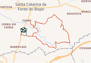
Tour Wandern von 11,2 km verfügbar auf Algarve, Faro, Santa Catarina da Fonte do Bispo. Diese Tour wird von BIBAR vorgeschlagen.
Beschreibung
Un tour dans la garrigue méditerranéenne et parmi les orangers. Ne pas faire par temps chaud, pas d'ombre. Beaucoup de chemins entrecroisés, facile de se tromper.
Ort
Land:
Portugal
Region :
Algarve
Abteilung/Provinz :
Faro
Kommune :
Santa Catarina da Fonte do Bispo
Standort:
Unknown
Gehen Sie:(Dec)
Gehen Sie:(UTM)
606937 ; 4110812 (29S) N.
Kommentare
Touren in der Umgebung
![Tour Zu Fuß Santa Catarina da Fonte do Bispo - Telheiros do Barro - Photo](https://media.geolcdn.com/t/375/260/50f40b1d-6d85-4938-a433-caad5910f4ac.jpeg&format=jpg&maxdim=2)
![Zu Fuß Zu Fuß](https://static1.geolcdn.com/sitytour/trail-icons/100.png)
Telheiros do Barro
Zu Fuß
Einfach
Santa Catarina da Fonte do Bispo,
Algarve,
Faro,
Portugal
![](/images/other/stat-length.png)
11,8 km | 15 km-effort
3h 25min
![](https://static1.geolcdn.com/siteimages/upload/files/16400158638029165_repeat_loop_refresh_sync_direction_icon.png)
Ja
![Tour Zu Fuß - Percurso Moinhos e Hortas - Photo](https://media.geolcdn.com/t/375/260/1643c608-7b4b-4e99-b624-4e3d9a417f9c.jpeg&format=jpg&maxdim=2)
![Zu Fuß Zu Fuß](https://static1.geolcdn.com/sitytour/trail-icons/100.png)
Percurso Moinhos e Hortas
Zu Fuß
Einfach
(1)
,
Algarve,
Faro,
Portugal
![](/images/other/stat-length.png)
8,7 km | 11,5 km-effort
2h 36min
![](https://static1.geolcdn.com/siteimages/upload/files/16400158638029165_repeat_loop_refresh_sync_direction_icon.png)
Ja
![Tour Zu Fuß Santa Catarina da Fonte do Bispo - Curral da Pedra - Photo](https://media.geolcdn.com/t/375/260/ext.jpg?maxdim=2&url=https%3A%2F%2Fstatic1.geolcdn.com%2Fsiteimages%2Fupload%2Ffiles%2F1545311037marcheuse_200dpi.jpg)
![Zu Fuß Zu Fuß](https://static1.geolcdn.com/sitytour/trail-icons/100.png)
Curral da Pedra
Zu Fuß
Einfach
Santa Catarina da Fonte do Bispo,
Algarve,
Faro,
Portugal
![](/images/other/stat-length.png)
6,9 km | 9,3 km-effort
2h 6min
![](https://static1.geolcdn.com/siteimages/upload/files/16400158638029165_repeat_loop_refresh_sync_direction_icon.png)
Ja
![Tour Wandern Moncarapacho e Fuseta - Cerro de Cabeca - Moncarapacho - Photo](https://media.geolcdn.com/t/375/260/ext.jpg?maxdim=2&url=https%3A%2F%2Fstatic1.geolcdn.com%2Fsiteimages%2Fupload%2Ffiles%2F1553511878bg_sport_marche.png)
![Wandern Wandern](https://static1.geolcdn.com/sitytour/trail-icons/101.png)
Cerro de Cabeca - Moncarapacho
Wandern
Schwierig
Moncarapacho e Fuseta,
Algarve,
Faro,
Portugal
![](/images/other/stat-length.png)
6,6 km | 9 km-effort
2h 37min
![](https://static1.geolcdn.com/siteimages/upload/files/16400158638029165_repeat_loop_refresh_sync_direction_icon.png)
Ja