![](/images/other/stat-length.png)
![Tour Wandern Villey-le-Sec - Villey le Sec - Photo](https://media.geolcdn.com/t/1900/400/ext.pjpeg?maxdim=2&url=https%3A%2F%2Fstatic1.geolcdn.com%2Fsiteimages%2Fupload%2Ffiles%2F1553511878bg_sport_marche.png)
Villey le Sec
joelclaudel
Benutzer
![Länge](/images/other/stat-length.png)
Länge
11,9 km
![Maximale Höhe](https://static1.geolcdn.com/siteimages/upload/files/1508320355ic_sort_altitude_max_24dp.png)
Maximale Höhe
332 m
![Positive Höhendifferenz](https://static1.geolcdn.com/siteimages/upload/files/1508320355ic_sort_den_pos_24dp.png)
Positive Höhendifferenz
162 m
![Km-Effort](/images/other/stat-length.png)
Km-Effort
14,1 km
![Min. Höhe](https://static1.geolcdn.com/siteimages/upload/files/1508320355ic_sort_altitude_min_24dp.png)
Min. Höhe
203 m
![Negative Höhendifferenz](https://static1.geolcdn.com/siteimages/upload/files/1508320355ic_sort_den_neg_24dp.png)
Negative Höhendifferenz
161 m
![Boucle](https://static1.geolcdn.com/siteimages/upload/files/16400158638029165_repeat_loop_refresh_sync_direction_icon.png)
Boucle
Ja
Erstellungsdatum :
2014-12-10 00:00:00.0
Letzte Änderung :
2014-12-10 00:00:00.0
![Wandern](https://static1.geolcdn.com/sitytour/trail-icons/101.png)
3h07
Schwierigkeit : Einfach
![Scannen Sie diesen QR-Code, um die Tour in der SityTrail-Anwendung zu öffnen](https://capi.geolives.com/qq0zvz2zws4bq2lad0pu/sitytour/trails/228337/qr.png?size=200)
Kostenlosegpshiking-Anwendung
Über SityTrail
Tour Wandern von 11,9 km verfügbar auf Großer Osten, Mörthe und Mosel, Villey-le-Sec. Diese Tour wird von joelclaudel vorgeschlagen.
Beschreibung
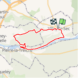
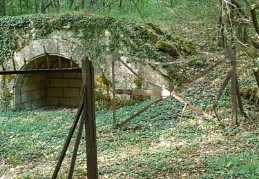
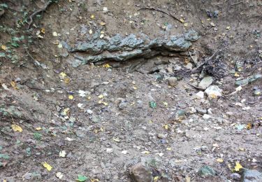
Descente vers le Moselle, barrage, Pierre la Treiche par la Moselle, Grottes Ste Reine,Fond de Chandelan, Forêt communale de Chaudeney,Fort de Villey le Sec
Ort
Land:
France
Region :
Großer Osten
Abteilung/Provinz :
Mörthe und Mosel
Kommune :
Villey-le-Sec
Standort:
Unknown
Gehen Sie:(Dec)
Gehen Sie:(UTM)
719217 ; 5393891 (31U) N.
Kommentare
Touren in der Umgebung
![Tour Pferd Villey-le-Sec - La Poudrière - Villey le Sec - Photo](https://media.geolcdn.com/t/375/260/ext.jpg?maxdim=2&url=https%3A%2F%2Fstatic1.geolcdn.com%2Fsiteimages%2Fupload%2Ffiles%2F1524743154cheval.jpg)
![Pferd Pferd](https://static1.geolcdn.com/sitytour/trail-icons/300.png)
La Poudrière - Villey le Sec
Pferd
Medium
(1)
Villey-le-Sec,
Großer Osten,
Mörthe und Mosel,
France
![](/images/other/stat-length.png)
8,6 km | 10,7 km-effort
1h 30min
![](https://static1.geolcdn.com/siteimages/upload/files/16400158638029165_repeat_loop_refresh_sync_direction_icon.png)
Ja
![Tour Wandern Sexey-aux-Forges - Sexey Aux Forges - Photo](https://media.geolcdn.com/t/375/260/b5abff6f-2c34-417b-95da-67ff19f21fe9.jpg&format=jpg&maxdim=2)
![Wandern Wandern](https://static1.geolcdn.com/sitytour/trail-icons/101.png)
Sexey Aux Forges
Wandern
Sehr schwierig
Sexey-aux-Forges,
Großer Osten,
Mörthe und Mosel,
France
![](/images/other/stat-length.png)
31 km | 38 km-effort
2h 38min
![](https://static1.geolcdn.com/siteimages/upload/files/16400158638029165_repeat_loop_refresh_sync_direction_icon.png)
Nein
![Tour Wandern Villey-le-Sec - Villey le sec - Les grottes - Le fort - Photo](https://media.geolcdn.com/t/375/260/174cce53-dd0d-4b92-98b6-4348d839bb57.jpg&format=jpg&maxdim=2)
![Wandern Wandern](https://static1.geolcdn.com/sitytour/trail-icons/101.png)
Villey le sec - Les grottes - Le fort
Wandern
Medium
Villey-le-Sec,
Großer Osten,
Mörthe und Mosel,
France
![](/images/other/stat-length.png)
10,5 km | 12,5 km-effort
4h 30min
![](https://static1.geolcdn.com/siteimages/upload/files/16400158638029165_repeat_loop_refresh_sync_direction_icon.png)
Ja
![Tour Wandern Toul - TOUL - LA CROIX D'ARGENT - Photo](https://media.geolcdn.com/t/375/260/e3f1b75b-7d57-4344-812a-03d7abcb3a24.jpg&format=jpg&maxdim=2)
![Wandern Wandern](https://static1.geolcdn.com/sitytour/trail-icons/101.png)
TOUL - LA CROIX D'ARGENT
Wandern
Sehr leicht
Toul,
Großer Osten,
Mörthe und Mosel,
France
![](/images/other/stat-length.png)
13 km | 14,5 km-effort
3h 22min
![](https://static1.geolcdn.com/siteimages/upload/files/16400158638029165_repeat_loop_refresh_sync_direction_icon.png)
Ja
![Tour Wandern Pierre-la-Treiche - pierre la triche grottes - Photo](https://media.geolcdn.com/t/375/260/ext.jpg?maxdim=2&url=https%3A%2F%2Fstatic1.geolcdn.com%2Fsiteimages%2Fupload%2Ffiles%2F1553511878bg_sport_marche.png)
![Wandern Wandern](https://static1.geolcdn.com/sitytour/trail-icons/101.png)
pierre la triche grottes
Wandern
Sehr leicht
(1)
Pierre-la-Treiche,
Großer Osten,
Mörthe und Mosel,
France
![](/images/other/stat-length.png)
5,7 km | 6,5 km-effort
1h 22min
![](https://static1.geolcdn.com/siteimages/upload/files/16400158638029165_repeat_loop_refresh_sync_direction_icon.png)
Ja
![Tour Wandern Pierre-la-Treiche - pierrre la treiche la deuille 1/5/2018 - Photo](https://media.geolcdn.com/t/375/260/ext.jpg?maxdim=2&url=https%3A%2F%2Fstatic1.geolcdn.com%2Fsiteimages%2Fupload%2Ffiles%2F1553511878bg_sport_marche.png)
![Wandern Wandern](https://static1.geolcdn.com/sitytour/trail-icons/101.png)
pierrre la treiche la deuille 1/5/2018
Wandern
Sehr leicht
(2)
Pierre-la-Treiche,
Großer Osten,
Mörthe und Mosel,
France
![](/images/other/stat-length.png)
10,8 km | 13,1 km-effort
2h 57min
![](https://static1.geolcdn.com/siteimages/upload/files/16400158638029165_repeat_loop_refresh_sync_direction_icon.png)
Ja
![Tour Wandern Villey-le-Sec - Villey le Sec Fort - Photo](https://media.geolcdn.com/t/375/260/ext.jpg?maxdim=2&url=https%3A%2F%2Fstatic1.geolcdn.com%2Fsiteimages%2Fupload%2Ffiles%2F1553511878bg_sport_marche.png)
![Wandern Wandern](https://static1.geolcdn.com/sitytour/trail-icons/101.png)
Villey le Sec Fort
Wandern
Sehr leicht
(1)
Villey-le-Sec,
Großer Osten,
Mörthe und Mosel,
France
![](/images/other/stat-length.png)
6,1 km | 7,5 km-effort
1h 38min
![](https://static1.geolcdn.com/siteimages/upload/files/16400158638029165_repeat_loop_refresh_sync_direction_icon.png)
Ja
![Tour Wandern Pierre-la-Treiche - pierre la treche - Photo](https://media.geolcdn.com/t/375/260/6cb3144c-b01a-4d7c-9c16-e77f5053a18f.jpg&format=jpg&maxdim=2)
![Wandern Wandern](https://static1.geolcdn.com/sitytour/trail-icons/101.png)
pierre la treche
Wandern
Medium
Pierre-la-Treiche,
Großer Osten,
Mörthe und Mosel,
France
![](/images/other/stat-length.png)
12,1 km | 0 m-effort
3h 26min
![](https://static1.geolcdn.com/siteimages/upload/files/16400158638029165_repeat_loop_refresh_sync_direction_icon.png)
Ja
![Tour Wandern Villey-le-Sec - PIERRE LA TREICHE - LES GROTTES ET LE FORT DE VILLEY LE SEC - Photo](https://media.geolcdn.com/t/375/260/8bac5130-764e-4dea-a415-b9d4f1cc2069.jpg&format=jpg&maxdim=2)
![Wandern Wandern](https://static1.geolcdn.com/sitytour/trail-icons/101.png)
PIERRE LA TREICHE - LES GROTTES ET LE FORT DE VILLEY LE SEC
Wandern
Einfach
Villey-le-Sec,
Großer Osten,
Mörthe und Mosel,
France
![](/images/other/stat-length.png)
10,6 km | 12,7 km-effort
4h 26min
![](https://static1.geolcdn.com/siteimages/upload/files/16400158638029165_repeat_loop_refresh_sync_direction_icon.png)
Ja