![](/images/other/stat-length.png)
![Tour Wandern Saint-Gervais - gorges du Gorgonnet - Photo](https://media.geolcdn.com/t/1900/400/ddede361-0ddc-44ee-afff-0bcfdbfb40ec.jpg&format=pjpeg&maxdim=2)
gorges du Gorgonnet
GuyVachet
Benutzer
![Länge](/images/other/stat-length.png)
![Maximale Höhe](https://static1.geolcdn.com/siteimages/upload/files/1508320355ic_sort_altitude_max_24dp.png)
![Positive Höhendifferenz](https://static1.geolcdn.com/siteimages/upload/files/1508320355ic_sort_den_pos_24dp.png)
![Km-Effort](/images/other/stat-length.png)
![Min. Höhe](https://static1.geolcdn.com/siteimages/upload/files/1508320355ic_sort_altitude_min_24dp.png)
![Negative Höhendifferenz](https://static1.geolcdn.com/siteimages/upload/files/1508320355ic_sort_den_neg_24dp.png)
![Boucle](https://static1.geolcdn.com/siteimages/upload/files/16400158638029165_repeat_loop_refresh_sync_direction_icon.png)
![Wandern](https://static1.geolcdn.com/sitytour/trail-icons/101.png)
5h18
Schwierigkeit : Medium
![Scannen Sie diesen QR-Code, um die Tour in der SityTrail-Anwendung zu öffnen](https://capi.geolives.com/qq0zvz2zws4bq2lad0pu/sitytour/trails/2273845/qr.png?size=200)
Kostenlosegpshiking-Anwendung
Über SityTrail
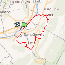
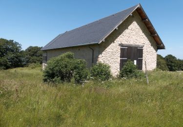
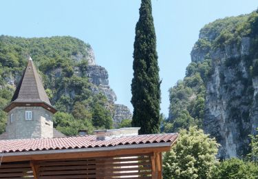
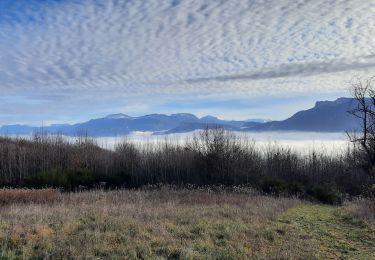
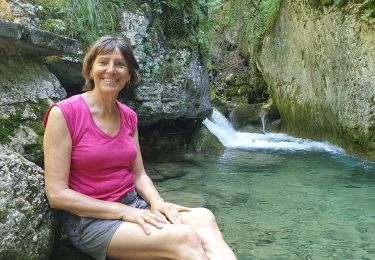
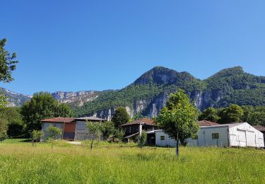
Tour Wandern von 14,6 km verfügbar auf Auvergne-Rhone-Alpen, Isère, Saint-Gervais. Diese Tour wird von GuyVachet vorgeschlagen.
Beschreibung
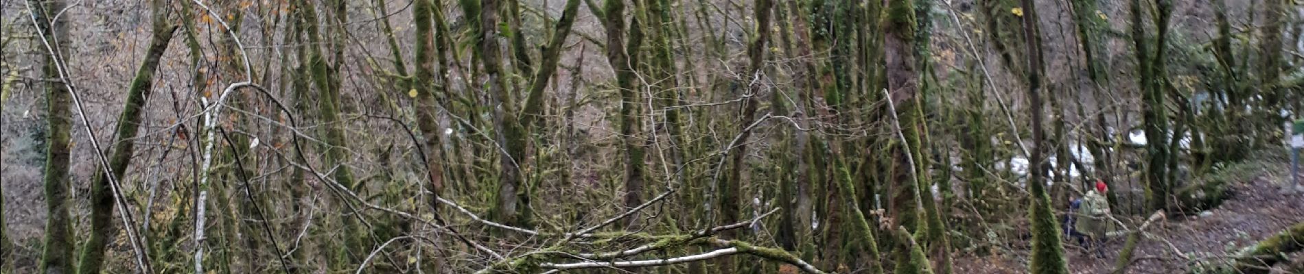
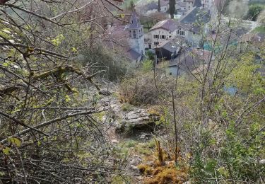
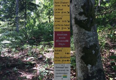
Boucle de fin de saison pour éviter la neige ou pour l'attendre, c'est selon... Départ du Port de St-Gervais (visite de l'ancienne fonderie royale en sus) dans un paysage de noyeraies. La montée est très soutenue au-dessus du Lignet dans un sentier bien tracé et non-exposé. A signaler la descente pas très aisée à partir des Gailleux pour rejoindre Pierre Mouton. Descente dans les gorges spectaculaires du Gorgonnet dans une ambiance "Rain forest" cf. la photo.
Ort
Kommentare
Touren in der Umgebung
![Tour Wandern Cognin-les-Gorges - gerlette abs - Photo](https://media.geolcdn.com/t/375/260/c8110e9f-bd5d-4d92-bba6-1a7936beeb04.jpg&format=jpg&maxdim=2)
![Wandern Wandern](https://static1.geolcdn.com/sitytour/trail-icons/101.png)
Wandern
![](/images/other/stat-length.png)
![](https://static1.geolcdn.com/siteimages/upload/files/16400158638029165_repeat_loop_refresh_sync_direction_icon.png)
![Tour Wandern La Rivière - 38 Versoud passage - Photo](https://media.geolcdn.com/t/375/260/db09042c-2e1e-4387-9270-a7021f004342.jpg&format=jpg&maxdim=2)
![Wandern Wandern](https://static1.geolcdn.com/sitytour/trail-icons/101.png)
Wandern
![](/images/other/stat-length.png)
![](https://static1.geolcdn.com/siteimages/upload/files/16400158638029165_repeat_loop_refresh_sync_direction_icon.png)
![Tour Wandern Saint-Gervais - Les Écouges - Pas de Pierre Taillée - Photo](https://media.geolcdn.com/t/375/260/c1514613-b24f-48ec-aa78-bb7bfa66a6b4.jpg&format=jpg&maxdim=2)
![Wandern Wandern](https://static1.geolcdn.com/sitytour/trail-icons/101.png)
Wandern
![](/images/other/stat-length.png)
![](https://static1.geolcdn.com/siteimages/upload/files/16400158638029165_repeat_loop_refresh_sync_direction_icon.png)
![Tour Wandern Cognin-les-Gorges - Cognin-les-Gorges - Gorges du Nan - Malleval-en-Vercors - Photo](https://media.geolcdn.com/t/375/260/ade7945e-a7c5-44bc-b392-a4cb822d8799.jpg&format=jpg&maxdim=2)
![Wandern Wandern](https://static1.geolcdn.com/sitytour/trail-icons/101.png)
Wandern
![](/images/other/stat-length.png)
![](https://static1.geolcdn.com/siteimages/upload/files/16400158638029165_repeat_loop_refresh_sync_direction_icon.png)
![Tour Wandern Chantesse - Traversée Chantesse Vitalieu Vinay - Photo](https://media.geolcdn.com/t/375/260/fcb44952-9760-427c-a2ff-8d11a64ffce4.jpg&format=jpg&maxdim=2)
![Wandern Wandern](https://static1.geolcdn.com/sitytour/trail-icons/101.png)
Wandern
![](/images/other/stat-length.png)
![](https://static1.geolcdn.com/siteimages/upload/files/16400158638029165_repeat_loop_refresh_sync_direction_icon.png)
![Tour Wandern Cognin-les-Gorges - Cognin les gorges - Photo](https://media.geolcdn.com/t/375/260/e58da0c6-5317-494c-a23f-3c145fb9c5f9.jpg&format=jpg&maxdim=2)
![Wandern Wandern](https://static1.geolcdn.com/sitytour/trail-icons/101.png)
Wandern
![](/images/other/stat-length.png)
![](https://static1.geolcdn.com/siteimages/upload/files/16400158638029165_repeat_loop_refresh_sync_direction_icon.png)
![Tour Wandern Cognin-les-Gorges - Les gorges du Nan - Photo](https://media.geolcdn.com/t/375/260/abcc4126-9132-4178-b560-2d3e1907f8cf.jpg&format=jpg&maxdim=2)
![Wandern Wandern](https://static1.geolcdn.com/sitytour/trail-icons/101.png)
Wandern
![](/images/other/stat-length.png)
![](https://static1.geolcdn.com/siteimages/upload/files/16400158638029165_repeat_loop_refresh_sync_direction_icon.png)
![Tour Wandern Saint-Gervais - Pas de Monbrand, - Photo](https://media.geolcdn.com/t/375/260/19cc0b37-367d-42ca-b426-cef76b115530.jpg&format=jpg&maxdim=2)
![Wandern Wandern](https://static1.geolcdn.com/sitytour/trail-icons/101.png)
Wandern
![](/images/other/stat-length.png)
![](https://static1.geolcdn.com/siteimages/upload/files/16400158638029165_repeat_loop_refresh_sync_direction_icon.png)
![Tour Wandern Rovon - Pied Aigu - Photo](https://media.geolcdn.com/t/375/260/5bbcd391-903a-4e39-a63f-b96173b2b1bb.jpg&format=jpg&maxdim=2)
![Wandern Wandern](https://static1.geolcdn.com/sitytour/trail-icons/101.png)
Wandern
![](/images/other/stat-length.png)
![](https://static1.geolcdn.com/siteimages/upload/files/16400158638029165_repeat_loop_refresh_sync_direction_icon.png)