![](/images/other/stat-length.png)
![Tour Wandern Plaisir - marche du 21 novembre 2019 - Photo](https://media.geolcdn.com/t/1900/400/ext.pjpeg?maxdim=2&url=https%3A%2F%2Fstatic1.geolcdn.com%2Fsiteimages%2Fupload%2Ffiles%2F1553511878bg_sport_marche.png)
marche du 21 novembre 2019
jimch58
Benutzer
![Länge](/images/other/stat-length.png)
Länge
7,1 km
![Maximale Höhe](https://static1.geolcdn.com/siteimages/upload/files/1508320355ic_sort_altitude_max_24dp.png)
Maximale Höhe
181 m
![Positive Höhendifferenz](https://static1.geolcdn.com/siteimages/upload/files/1508320355ic_sort_den_pos_24dp.png)
Positive Höhendifferenz
82 m
![Km-Effort](/images/other/stat-length.png)
Km-Effort
8,2 km
![Min. Höhe](https://static1.geolcdn.com/siteimages/upload/files/1508320355ic_sort_altitude_min_24dp.png)
Min. Höhe
130 m
![Negative Höhendifferenz](https://static1.geolcdn.com/siteimages/upload/files/1508320355ic_sort_den_neg_24dp.png)
Negative Höhendifferenz
82 m
![Boucle](https://static1.geolcdn.com/siteimages/upload/files/16400158638029165_repeat_loop_refresh_sync_direction_icon.png)
Boucle
Ja
Erstellungsdatum :
2019-11-21 08:16:17.126
Letzte Änderung :
2019-11-21 15:47:07.353
![Wandern](https://static1.geolcdn.com/sitytour/trail-icons/101.png)
1h52
Schwierigkeit : Sehr leicht
![Scannen Sie diesen QR-Code, um die Tour in der SityTrail-Anwendung zu öffnen](https://capi.geolives.com/qq0zvz2zws4bq2lad0pu/sitytour/trails/2268912/qr.png?size=200)
Kostenlosegpshiking-Anwendung
Über SityTrail
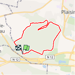
Tour Wandern von 7,1 km verfügbar auf Île-de-France, Yvelines, Plaisir. Diese Tour wird von jimch58 vorgeschlagen.
Beschreibung
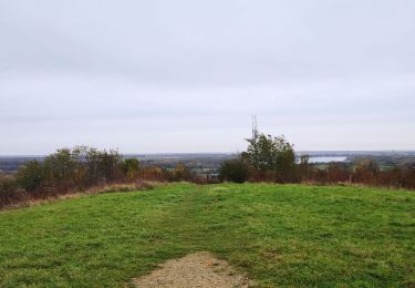
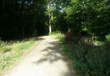
Le bois de Ste-Apolline dans le sens des aiguilles d'une montre, avec un temps clément et de superbes couleurs d'automne.
Ort
Land:
France
Region :
Île-de-France
Abteilung/Provinz :
Yvelines
Kommune :
Plaisir
Standort:
Unknown
Gehen Sie:(Dec)
Gehen Sie:(UTM)
420736 ; 5405900 (31U) N.
Kommentare
Touren in der Umgebung
![Tour Wandern Bazoches-sur-Guyonne - _Les chaumières de Bazoches - Photo](https://media.geolcdn.com/t/375/260/ext.jpg?maxdim=2&url=https%3A%2F%2Fservices.sitytrail.com%2FGeolivesWS%2FDownloadMedia.ashx%3FTrailID%3D784205%26Media%3D50afe0be-7e96-47da-a0b5-41d8dcd474a4.JPG)
![Wandern Wandern](https://static1.geolcdn.com/sitytour/trail-icons/101.png)
_Les chaumières de Bazoches
Wandern
Medium
(2)
Bazoches-sur-Guyonne,
Île-de-France,
Yvelines,
France
![](/images/other/stat-length.png)
8,5 km | 10,5 km-effort
2h 0min
![](https://static1.geolcdn.com/siteimages/upload/files/16400158638029165_repeat_loop_refresh_sync_direction_icon.png)
Ja
![Tour Wandern Le Tremblay-sur-Mauldre - rando du 12/03/2015 - Photo](https://media.geolcdn.com/t/375/260/ext.jpg?maxdim=2&url=https%3A%2F%2Fservices.sitytrail.com%2FGeolivesWS%2FDownloadMedia.ashx%3FTrailID%3D394961%26Media%3Dfix__20150312095010.jpg)
![Wandern Wandern](https://static1.geolcdn.com/sitytour/trail-icons/101.png)
rando du 12/03/2015
Wandern
Einfach
(1)
Le Tremblay-sur-Mauldre,
Île-de-France,
Yvelines,
France
![](/images/other/stat-length.png)
7,1 km | 9,3 km-effort
1h 59min
![](https://static1.geolcdn.com/siteimages/upload/files/16400158638029165_repeat_loop_refresh_sync_direction_icon.png)
Ja
![Tour Wandern Plaisir - Plaisir et forêt de Ste Apolline - Photo](https://media.geolcdn.com/t/375/260/ext.jpg?maxdim=2&url=https%3A%2F%2Fservices.sitytrail.com%2FGeolivesWS%2FDownloadMedia.ashx%3FTrailID%3D317587%26Media%3D16850_6.jpg)
![Wandern Wandern](https://static1.geolcdn.com/sitytour/trail-icons/101.png)
Plaisir et forêt de Ste Apolline
Wandern
Medium
(2)
Plaisir,
Île-de-France,
Yvelines,
France
![](/images/other/stat-length.png)
12,7 km | 15,4 km-effort
2h 30min
![](https://static1.geolcdn.com/siteimages/upload/files/16400158638029165_repeat_loop_refresh_sync_direction_icon.png)
Ja
![Tour Mountainbike Élancourt - VTT elancourt - Photo](https://media.geolcdn.com/t/375/260/7baccbc1-8d3f-4bc5-8bd1-9856d64ea15b.jpg&format=jpg&maxdim=2)
![Mountainbike Mountainbike](https://static1.geolcdn.com/sitytour/trail-icons/202.png)
VTT elancourt
Mountainbike
Einfach
Élancourt,
Île-de-France,
Yvelines,
France
![](/images/other/stat-length.png)
26 km | 29 km-effort
2h 1min
![](https://static1.geolcdn.com/siteimages/upload/files/16400158638029165_repeat_loop_refresh_sync_direction_icon.png)
Ja
![Tour Wandern Bazoches-sur-Guyonne - Bazoches - Photo](https://media.geolcdn.com/t/375/260/87864db8-2755-4cea-9ed1-b64f1c4148b4.jpg&format=jpg&maxdim=2)
![Wandern Wandern](https://static1.geolcdn.com/sitytour/trail-icons/101.png)
Bazoches
Wandern
Medium
Bazoches-sur-Guyonne,
Île-de-France,
Yvelines,
France
![](/images/other/stat-length.png)
6 km | 7,5 km-effort
2h 26min
![](https://static1.geolcdn.com/siteimages/upload/files/16400158638029165_repeat_loop_refresh_sync_direction_icon.png)
Ja
![Tour Flugzeug Neauphle-le-Vieux - Chavenay Etretat - Photo](https://media.geolcdn.com/t/375/260/65d156d0-9e35-4d1c-b0c6-dae3b8d81c13.jpg&format=jpg&maxdim=2)
![Flugzeug Flugzeug](https://static1.geolcdn.com/sitytour/trail-icons/601.png)
Chavenay Etretat
Flugzeug
Sehr leicht
Neauphle-le-Vieux,
Île-de-France,
Yvelines,
France
![](/images/other/stat-length.png)
359 km | 441 km-effort
2h 3min
![](https://static1.geolcdn.com/siteimages/upload/files/16400158638029165_repeat_loop_refresh_sync_direction_icon.png)
Nein
![Tour Wandern Maurepas - 10852243-ADAL_MAUREPAS_14012020 - Photo](https://media.geolcdn.com/t/375/260/ext.jpg?maxdim=2&url=https%3A%2F%2Fstatic1.geolcdn.com%2Fsiteimages%2Fupload%2Ffiles%2F1553511878bg_sport_marche.png)
![Wandern Wandern](https://static1.geolcdn.com/sitytour/trail-icons/101.png)
10852243-ADAL_MAUREPAS_14012020
Wandern
Schwierig
(1)
Maurepas,
Île-de-France,
Yvelines,
France
![](/images/other/stat-length.png)
17,8 km | 22 km-effort
4h 49min
![](https://static1.geolcdn.com/siteimages/upload/files/16400158638029165_repeat_loop_refresh_sync_direction_icon.png)
Ja
![Tour Wandern Maurepas - marche du 7 novembre 2019 - Photo](https://media.geolcdn.com/t/375/260/e041706d-541d-4a0a-91b0-d2e09546e303.jpg&format=jpg&maxdim=2)
![Wandern Wandern](https://static1.geolcdn.com/sitytour/trail-icons/101.png)
marche du 7 novembre 2019
Wandern
Medium
Maurepas,
Île-de-France,
Yvelines,
France
![](/images/other/stat-length.png)
8,6 km | 9,4 km-effort
2h 11min
![](https://static1.geolcdn.com/siteimages/upload/files/16400158638029165_repeat_loop_refresh_sync_direction_icon.png)
Nein
![Tour Wandern Maurepas - kasipadvil - Photo](https://media.geolcdn.com/t/375/260/a2242cb7-8b9f-4adf-859a-48b385252eec.jpg&format=jpg&maxdim=2)
![Wandern Wandern](https://static1.geolcdn.com/sitytour/trail-icons/101.png)
kasipadvil
Wandern
Einfach
Maurepas,
Île-de-France,
Yvelines,
France
![](/images/other/stat-length.png)
4,1 km | 4,8 km-effort
1h 1min
![](https://static1.geolcdn.com/siteimages/upload/files/16400158638029165_repeat_loop_refresh_sync_direction_icon.png)
Ja