![](/images/other/stat-length.png)
![Tour Wandern Névache - J5 G2 col des Thures Lac Chevillon retour par sentier des Combes - Photo](https://media.geolcdn.com/t/1900/400/d5009662-84c7-48d6-bdf7-3fa19329d844.jpg&format=pjpeg&maxdim=2)
J5 G2 col des Thures Lac Chevillon retour par sentier des Combes
Névache Aout 2020 REV 83
La Clarée un must pour randonner alors à nous d'en profiter ....
![Länge](/images/other/stat-length.png)
Länge
11,8 km
![Maximale Höhe](https://static1.geolcdn.com/siteimages/upload/files/1508320355ic_sort_altitude_max_24dp.png)
Maximale Höhe
2198 m
![Positive Höhendifferenz](https://static1.geolcdn.com/siteimages/upload/files/1508320355ic_sort_den_pos_24dp.png)
Positive Höhendifferenz
655 m
![Km-Effort](/images/other/stat-length.png)
Km-Effort
21 km
![Min. Höhe](https://static1.geolcdn.com/siteimages/upload/files/1508320355ic_sort_altitude_min_24dp.png)
Min. Höhe
1602 m
![Negative Höhendifferenz](https://static1.geolcdn.com/siteimages/upload/files/1508320355ic_sort_den_neg_24dp.png)
Negative Höhendifferenz
655 m
![Boucle](https://static1.geolcdn.com/siteimages/upload/files/16400158638029165_repeat_loop_refresh_sync_direction_icon.png)
Boucle
Ja
Erstellungsdatum :
2019-11-21 09:08:03.85
Letzte Änderung :
2019-11-21 09:16:44.497
![Wandern](https://static1.geolcdn.com/sitytour/trail-icons/101.png)
4h09
Schwierigkeit : Medium
![Scannen Sie diesen QR-Code, um die Tour in der SityTrail-Anwendung zu öffnen](https://capi.geolives.com/qq0zvz2zws4bq2lad0pu/sitytour/trails/2268877/qr.png?size=200)
Kostenlosegpshiking-Anwendung
Über SityTrail
Tour Wandern von 11,8 km verfügbar auf Provence-Alpes-Côte d'Azur, Hochalpen, Névache. Diese Tour wird von Névache Aout 2020 REV 83 vorgeschlagen.
Beschreibung
REV Névache 2020 J5 G2 départ de l'hôtel Vallée des thures Cheminées coiffées Col des thures Lac Chevillon retour par sentier des Combes
Ort
Land:
France
Region :
Provence-Alpes-Côte d'Azur
Abteilung/Provinz :
Hochalpen
Kommune :
Névache
Standort:
Unknown
Gehen Sie:(Dec)
Gehen Sie:(UTM)
313564 ; 4987777 (32T) N.
Kommentare
Touren in der Umgebung
![Tour Wandern Névache - Via Alpina - R127: Névache > Le Monêtier-les-Bains - Photo](https://media.geolcdn.com/t/375/260/ext.jpg?maxdim=2&url=https%3A%2F%2Fservices.sitytrail.com%2FGeolivesWS%2FDownloadMedia.ashx%3FTrailID%3D109685%26Media%3D4354_1.jpg)
![Wandern Wandern](https://static1.geolcdn.com/sitytour/trail-icons/101.png)
Via Alpina - R127: Névache > Le Monêtier-les-Bains
Wandern
Schwierig
(1)
Névache,
Provence-Alpes-Côte d'Azur,
Hochalpen,
France
![](/images/other/stat-length.png)
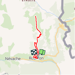
15,5 km | 28 km-effort
5h 0min
![](https://static1.geolcdn.com/siteimages/upload/files/16400158638029165_repeat_loop_refresh_sync_direction_icon.png)
Nein
![Tour Wandern Névache - Gardiette - Photo](https://media.geolcdn.com/t/375/260/e5194ed3-9676-4aff-8712-0683ead2c91e.jpg&format=jpg&maxdim=2)
![Wandern Wandern](https://static1.geolcdn.com/sitytour/trail-icons/101.png)
Gardiette
Wandern
Einfach
Névache,
Provence-Alpes-Côte d'Azur,
Hochalpen,
France
![](/images/other/stat-length.png)
16,6 km | 32 km-effort
7h 33min
![](https://static1.geolcdn.com/siteimages/upload/files/16400158638029165_repeat_loop_refresh_sync_direction_icon.png)
Ja
![Tour Wandern Névache - Plampinet Clarée aval - Photo](https://media.geolcdn.com/t/375/260/ext.jpg?maxdim=2&url=https%3A%2F%2Fservices.sitytrail.com%2FGeolivesWS%2FDownloadMedia.ashx%3FTrailID%3D307010%26Media%3Dfix__20140529140625.jpg)
![Wandern Wandern](https://static1.geolcdn.com/sitytour/trail-icons/101.png)
Plampinet Clarée aval
Wandern
Einfach
Névache,
Provence-Alpes-Côte d'Azur,
Hochalpen,
France
![](/images/other/stat-length.png)
8,2 km | 10 km-effort
2h 17min
![](https://static1.geolcdn.com/siteimages/upload/files/16400158638029165_repeat_loop_refresh_sync_direction_icon.png)
Ja
![Tour Wandern Névache - Plampinet Clarée amont - Photo](https://media.geolcdn.com/t/375/260/ext.jpg?maxdim=2&url=https%3A%2F%2Fservices.sitytrail.com%2FGeolivesWS%2FDownloadMedia.ashx%3FTrailID%3D307006%26Media%3Dfix__20140529101431.jpg)
![Wandern Wandern](https://static1.geolcdn.com/sitytour/trail-icons/101.png)
Plampinet Clarée amont
Wandern
Einfach
(1)
Névache,
Provence-Alpes-Côte d'Azur,
Hochalpen,
France
![](/images/other/stat-length.png)
6,2 km | 7,7 km-effort
1h 27min
![](https://static1.geolcdn.com/siteimages/upload/files/16400158638029165_repeat_loop_refresh_sync_direction_icon.png)
Ja
![Tour Wandern Névache - L'Aiguille rouge et Lac Chavillon : Panorama sur la vallée de la Clarée - Photo](https://media.geolcdn.com/t/375/260/572d3bde-ec6e-47da-a185-1da154c90648.jpeg&format=jpg&maxdim=2)
![Wandern Wandern](https://static1.geolcdn.com/sitytour/trail-icons/101.png)
L'Aiguille rouge et Lac Chavillon : Panorama sur la vallée de la Clarée
Wandern
Sehr schwierig
Névache,
Provence-Alpes-Côte d'Azur,
Hochalpen,
France
![](/images/other/stat-length.png)
15,4 km | 29 km-effort
6h 29min
![](https://static1.geolcdn.com/siteimages/upload/files/16400158638029165_repeat_loop_refresh_sync_direction_icon.png)
Ja
![Tour Wandern Névache - Boucle au dessus de Névache par le Refuge de Buffère et Côte Rouge - Photo](https://media.geolcdn.com/t/375/260/bf24706c-669b-4692-81a8-efbc054dd6e6.jpeg&format=jpg&maxdim=2)
![Wandern Wandern](https://static1.geolcdn.com/sitytour/trail-icons/101.png)
Boucle au dessus de Névache par le Refuge de Buffère et Côte Rouge
Wandern
Sehr schwierig
Névache,
Provence-Alpes-Côte d'Azur,
Hochalpen,
France
![](/images/other/stat-length.png)
14,8 km | 24 km-effort
5h 26min
![](https://static1.geolcdn.com/siteimages/upload/files/16400158638029165_repeat_loop_refresh_sync_direction_icon.png)
Ja
![Tour Wandern Névache - lac de Cristol,, Nevache - Photo](https://media.geolcdn.com/t/375/260/ext.jpg?maxdim=2&url=https%3A%2F%2Fstatic1.geolcdn.com%2Fsiteimages%2Fupload%2Ffiles%2F1553511878bg_sport_marche.png)
![Wandern Wandern](https://static1.geolcdn.com/sitytour/trail-icons/101.png)
lac de Cristol,, Nevache
Wandern
Sehr schwierig
(1)
Névache,
Provence-Alpes-Côte d'Azur,
Hochalpen,
France
![](/images/other/stat-length.png)
11,2 km | 22 km-effort
4h 55min
![](https://static1.geolcdn.com/siteimages/upload/files/16400158638029165_repeat_loop_refresh_sync_direction_icon.png)
Ja
![Tour Wandern Névache - LA CLAREE: balcon de la claree - Photo](https://media.geolcdn.com/t/375/260/d371ed49-40d8-478d-9508-5cf2ffc79f21.jpg&format=jpg&maxdim=2)
![Wandern Wandern](https://static1.geolcdn.com/sitytour/trail-icons/101.png)
LA CLAREE: balcon de la claree
Wandern
Medium
Névache,
Provence-Alpes-Côte d'Azur,
Hochalpen,
France
![](/images/other/stat-length.png)
14,2 km | 23 km-effort
4h 7min
![](https://static1.geolcdn.com/siteimages/upload/files/16400158638029165_repeat_loop_refresh_sync_direction_icon.png)
Ja
![Wandern Wandern](https://static1.geolcdn.com/sitytour/trail-icons/101.png)
Col des Thures - Lac Chavillon
Wandern
Medium
Névache,
Provence-Alpes-Côte d'Azur,
Hochalpen,
France
![](/images/other/stat-length.png)
5,3 km | 11,1 km-effort
2h 31min
![](https://static1.geolcdn.com/siteimages/upload/files/16400158638029165_repeat_loop_refresh_sync_direction_icon.png)
Nein