![](/images/other/stat-length.png)
![Tour Wandern Le Bar-sur-Loup - Aqueducs du Foulon et du loup - Photo](https://media.geolcdn.com/t/1900/400/ext.pjpeg?maxdim=2&url=https%3A%2F%2Fstatic1.geolcdn.com%2Fsiteimages%2Fupload%2Ffiles%2F1553511878bg_sport_marche.png)
Aqueducs du Foulon et du loup
jmheydorff
Benutzer
![Länge](/images/other/stat-length.png)
Länge
10,3 km
![Maximale Höhe](https://static1.geolcdn.com/siteimages/upload/files/1508320355ic_sort_altitude_max_24dp.png)
Maximale Höhe
759 m
![Positive Höhendifferenz](https://static1.geolcdn.com/siteimages/upload/files/1508320355ic_sort_den_pos_24dp.png)
Positive Höhendifferenz
624 m
![Km-Effort](/images/other/stat-length.png)
Km-Effort
18,6 km
![Min. Höhe](https://static1.geolcdn.com/siteimages/upload/files/1508320355ic_sort_altitude_min_24dp.png)
Min. Höhe
307 m
![Negative Höhendifferenz](https://static1.geolcdn.com/siteimages/upload/files/1508320355ic_sort_den_neg_24dp.png)
Negative Höhendifferenz
624 m
![Boucle](https://static1.geolcdn.com/siteimages/upload/files/16400158638029165_repeat_loop_refresh_sync_direction_icon.png)
Boucle
Ja
Erstellungsdatum :
2014-12-10 00:00:00.0
Letzte Änderung :
2014-12-10 00:00:00.0
![Wandern](https://static1.geolcdn.com/sitytour/trail-icons/101.png)
4h12
Schwierigkeit : Medium
![Scannen Sie diesen QR-Code, um die Tour in der SityTrail-Anwendung zu öffnen](https://capi.geolives.com/qq0zvz2zws4bq2lad0pu/sitytour/trails/226530/qr.png?size=200)
Kostenlosegpshiking-Anwendung
Über SityTrail
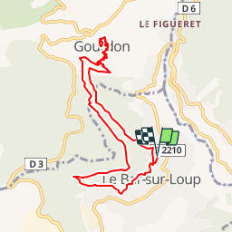
Tour Wandern von 10,3 km verfügbar auf Provence-Alpes-Côte d'Azur, Seealpen, Le Bar-sur-Loup. Diese Tour wird von jmheydorff vorgeschlagen.
Beschreibung
pkg Bar sur loup, près du cimetière. Monter (multiples chemins possibles) rejoindre le canal supérieur, l'Aqueduc du Foulon; monter à Gourdon; redescendre jusqu'au canal inférieur (Aqueduc du Loup), qui nous ramène à Bar
Ort
Land:
France
Region :
Provence-Alpes-Côte d'Azur
Abteilung/Provinz :
Seealpen
Kommune :
Le Bar-sur-Loup
Standort:
Unknown
Gehen Sie:(Dec)
Gehen Sie:(UTM)
338001 ; 4840989 (32T) N.
Kommentare
Touren in der Umgebung
![Tour Wandern Gourdon - Plateau de Cavillore, la Forteresse - Gourdon - Photo](https://media.geolcdn.com/t/375/260/ext.jpg?maxdim=2&url=https%3A%2F%2Fservices.sitytrail.com%2FGeolivesWS%2FDownloadMedia.ashx%3FTrailID%3D214895%26Media%3D15446_1.jpg)
![Wandern Wandern](https://static1.geolcdn.com/sitytour/trail-icons/101.png)
Plateau de Cavillore, la Forteresse - Gourdon
Wandern
Medium
(3)
Gourdon,
Provence-Alpes-Côte d'Azur,
Seealpen,
France
![](/images/other/stat-length.png)
7,2 km | 11,2 km-effort
2h 15min
![](https://static1.geolcdn.com/siteimages/upload/files/16400158638029165_repeat_loop_refresh_sync_direction_icon.png)
Ja
![Tour Wandern Le Bar-sur-Loup - Le Bar sur Loup Gourdon Barre et plateau de Cavillore réel - Photo](https://media.geolcdn.com/t/375/260/c167fd77-8053-444f-a9c7-0c602a316e76.jpg&format=jpg&maxdim=2)
![Wandern Wandern](https://static1.geolcdn.com/sitytour/trail-icons/101.png)
Le Bar sur Loup Gourdon Barre et plateau de Cavillore réel
Wandern
Sehr schwierig
Le Bar-sur-Loup,
Provence-Alpes-Côte d'Azur,
Seealpen,
France
![](/images/other/stat-length.png)
19,3 km | 32 km-effort
7h 19min
![](https://static1.geolcdn.com/siteimages/upload/files/16400158638029165_repeat_loop_refresh_sync_direction_icon.png)
Ja
![Tour Wandern Le Bar-sur-Loup - rando - Photo](https://media.geolcdn.com/t/375/260/fa0ef731-2bd1-40ee-a714-99f05472c6fe.jpg&format=jpg&maxdim=2)
![Wandern Wandern](https://static1.geolcdn.com/sitytour/trail-icons/101.png)
rando
Wandern
Sehr schwierig
Le Bar-sur-Loup,
Provence-Alpes-Côte d'Azur,
Seealpen,
France
![](/images/other/stat-length.png)
12,1 km | 21 km-effort
6h 9min
![](https://static1.geolcdn.com/siteimages/upload/files/16400158638029165_repeat_loop_refresh_sync_direction_icon.png)
Nein
![Tour Zu Fuß Le Rouret - Le Camp romain - Photo](https://media.geolcdn.com/t/375/260/d6aefa76-dc44-4fc7-8d77-d19148310732.jpeg&format=jpg&maxdim=2)
![Zu Fuß Zu Fuß](https://static1.geolcdn.com/sitytour/trail-icons/100.png)
Le Camp romain
Zu Fuß
Einfach
Le Rouret,
Provence-Alpes-Côte d'Azur,
Seealpen,
France
![](/images/other/stat-length.png)
6,8 km | 9,6 km-effort
2h 10min
![](https://static1.geolcdn.com/siteimages/upload/files/16400158638029165_repeat_loop_refresh_sync_direction_icon.png)
Ja
![Tour Zu Fuß Le Bar-sur-Loup - Circuit de la Malle - Photo](https://media.geolcdn.com/t/375/260/9cf230aa-9298-45ef-9b30-612a3965bbab.jpeg&format=jpg&maxdim=2)
![Zu Fuß Zu Fuß](https://static1.geolcdn.com/sitytour/trail-icons/100.png)
Circuit de la Malle
Zu Fuß
Schwierig
Le Bar-sur-Loup,
Provence-Alpes-Côte d'Azur,
Seealpen,
France
![](/images/other/stat-length.png)
22 km | 34 km-effort
7h 43min
![](https://static1.geolcdn.com/siteimages/upload/files/16400158638029165_repeat_loop_refresh_sync_direction_icon.png)
Ja
![Tour Zu Fuß Le Bar-sur-Loup - Circuit du Paradis - Photo](https://media.geolcdn.com/t/375/260/c599f589-6942-4b9f-bfea-287eb9516c31.jpeg&format=jpg&maxdim=2)
![Zu Fuß Zu Fuß](https://static1.geolcdn.com/sitytour/trail-icons/100.png)
Circuit du Paradis
Zu Fuß
Einfach
Le Bar-sur-Loup,
Provence-Alpes-Côte d'Azur,
Seealpen,
France
![](/images/other/stat-length.png)
8,1 km | 15 km-effort
3h 24min
![](https://static1.geolcdn.com/siteimages/upload/files/16400158638029165_repeat_loop_refresh_sync_direction_icon.png)
Ja
![Tour Zu Fuß Gourdon - Plateau de Cavillore - Photo](https://media.geolcdn.com/t/375/260/094c0018-0a4d-4f34-8879-15bc82519f15.jpeg&format=jpg&maxdim=2)
![Zu Fuß Zu Fuß](https://static1.geolcdn.com/sitytour/trail-icons/100.png)
Plateau de Cavillore
Zu Fuß
Einfach
Gourdon,
Provence-Alpes-Côte d'Azur,
Seealpen,
France
![](/images/other/stat-length.png)
5,9 km | 10 km-effort
2h 16min
![](https://static1.geolcdn.com/siteimages/upload/files/16400158638029165_repeat_loop_refresh_sync_direction_icon.png)
Ja
![Tour Zu Fuß Courmes - Plateau de Saint-Barnabé - Photo](https://media.geolcdn.com/t/375/260/e5884674-6345-4525-aa20-82da8aac2558.jpeg&format=jpg&maxdim=2)
![Zu Fuß Zu Fuß](https://static1.geolcdn.com/sitytour/trail-icons/100.png)
Plateau de Saint-Barnabé
Zu Fuß
Einfach
Courmes,
Provence-Alpes-Côte d'Azur,
Seealpen,
France
![](/images/other/stat-length.png)
6,6 km | 11,1 km-effort
2h 31min
![](https://static1.geolcdn.com/siteimages/upload/files/16400158638029165_repeat_loop_refresh_sync_direction_icon.png)
Ja
![Tour Zu Fuß Roquefort-les-Pins - Le Rucher - Photo](https://media.geolcdn.com/t/375/260/8984dec4-46ee-4507-9355-103df05628e2.jpeg&format=jpg&maxdim=2)
![Zu Fuß Zu Fuß](https://static1.geolcdn.com/sitytour/trail-icons/100.png)
Le Rucher
Zu Fuß
Einfach
Roquefort-les-Pins,
Provence-Alpes-Côte d'Azur,
Seealpen,
France
![](/images/other/stat-length.png)
3,7 km | 4,8 km-effort
1h 5min
![](https://static1.geolcdn.com/siteimages/upload/files/16400158638029165_repeat_loop_refresh_sync_direction_icon.png)
Nein
Attention au départ, il faut faire un détour par le village. Tunnels 29 et 27 : grosses fuites, 5 à 10 cm d'eau. Super rando.