![](/images/other/stat-length.png)
![Tour Andere Aktivitäten Olun - Villars Roc d''Orsay - Photo](https://media.geolcdn.com/t/1900/400/ext.pjpeg?maxdim=2&url=https%3A%2F%2Fstatic1.geolcdn.com%2Fsiteimages%2Fupload%2Ffiles%2F1545311037marcheuse_200dpi.jpg)
Villars Roc d''Orsay
Bachmann
Benutzer
![Länge](/images/other/stat-length.png)
Länge
5,5 km
![Maximale Höhe](https://static1.geolcdn.com/siteimages/upload/files/1508320355ic_sort_altitude_max_24dp.png)
Maximale Höhe
1950 m
![Positive Höhendifferenz](https://static1.geolcdn.com/siteimages/upload/files/1508320355ic_sort_den_pos_24dp.png)
Positive Höhendifferenz
713 m
![Km-Effort](/images/other/stat-length.png)
Km-Effort
13,3 km
![Min. Höhe](https://static1.geolcdn.com/siteimages/upload/files/1508320355ic_sort_altitude_min_24dp.png)
Min. Höhe
1293 m
![Negative Höhendifferenz](https://static1.geolcdn.com/siteimages/upload/files/1508320355ic_sort_den_neg_24dp.png)
Negative Höhendifferenz
197 m
![Boucle](https://static1.geolcdn.com/siteimages/upload/files/16400158638029165_repeat_loop_refresh_sync_direction_icon.png)
Boucle
Nein
Erstellungsdatum :
2014-12-11 00:00:00.0
Letzte Änderung :
2014-12-11 00:00:00.0
![Andere Aktivitäten](https://static1.geolcdn.com/sitytour/trail-icons/900.png)
--
Schwierigkeit : Unbekannt
![Scannen Sie diesen QR-Code, um die Tour in der SityTrail-Anwendung zu öffnen](https://capi.geolives.com/qq0zvz2zws4bq2lad0pu/sitytour/trails/22589/qr.png?size=200)
Kostenlosegpshiking-Anwendung
Über SityTrail
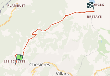
Tour Andere Aktivitäten von 5,5 km verfügbar auf Waadt, District d'Aigle, Olun. Diese Tour wird von Bachmann vorgeschlagen.
Beschreibung
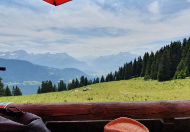
Charmante balade, variée, avec belle vue et descente (ou montée!) possible en train. Départ des Ecoveys. Si option train, laisser une voiture à la gare de Villars.
Ort
Land:
Switzerland
Region :
Waadt
Abteilung/Provinz :
District d'Aigle
Kommune :
Olun
Standort:
Unknown
Gehen Sie:(Dec)
Gehen Sie:(UTM)
348217 ; 5129430 (32T) N.
Kommentare
Touren in der Umgebung
![Tour Zu Fuß Olun - Sentier du Sel - Photo](https://media.geolcdn.com/t/375/260/57aaa27c-a754-41df-973e-5368236700f5.jpeg&format=jpg&maxdim=2)
![Zu Fuß Zu Fuß](https://static1.geolcdn.com/sitytour/trail-icons/100.png)
Sentier du Sel
Zu Fuß
Einfach
Olun,
Waadt,
District d'Aigle,
Switzerland
![](/images/other/stat-length.png)
4,5 km | 8 km-effort
1h 49min
![](https://static1.geolcdn.com/siteimages/upload/files/16400158638029165_repeat_loop_refresh_sync_direction_icon.png)
Nein
![Tour Wandern Olun - Le grand Chamossaire - Photo](https://media.geolcdn.com/t/375/260/a67746b6-a3a3-4764-a01c-8939bef03c6f.jpg&format=jpg&maxdim=2)
![Wandern Wandern](https://static1.geolcdn.com/sitytour/trail-icons/101.png)
Le grand Chamossaire
Wandern
Medium
Olun,
Waadt,
District d'Aigle,
Switzerland
![](/images/other/stat-length.png)
6,6 km | 15,6 km-effort
3h 48min
![](https://static1.geolcdn.com/siteimages/upload/files/16400158638029165_repeat_loop_refresh_sync_direction_icon.png)
Nein
![Tour Andere Aktivitäten Leysin - bdr00_Leysin_StGingolphe - Photo](https://media.geolcdn.com/t/375/260/ext.jpg?maxdim=2&url=https%3A%2F%2Fstatic1.geolcdn.com%2Fsiteimages%2Fupload%2Ffiles%2F1545311037marcheuse_200dpi.jpg)
![Andere Aktivitäten Andere Aktivitäten](https://static1.geolcdn.com/sitytour/trail-icons/900.png)
bdr00_Leysin_StGingolphe
Andere Aktivitäten
Sehr leicht
Leysin,
Waadt,
District d'Aigle,
Switzerland
![](/images/other/stat-length.png)
26 km | 32 km-effort
Unbekannt
![](https://static1.geolcdn.com/siteimages/upload/files/16400158638029165_repeat_loop_refresh_sync_direction_icon.png)
Nein
![Tour Andere Aktivitäten Leysin - xxx00_Leysin_StGingolphe - Photo](https://media.geolcdn.com/t/375/260/ext.jpg?maxdim=2&url=https%3A%2F%2Fstatic1.geolcdn.com%2Fsiteimages%2Fupload%2Ffiles%2F1545311037marcheuse_200dpi.jpg)
![Andere Aktivitäten Andere Aktivitäten](https://static1.geolcdn.com/sitytour/trail-icons/900.png)
xxx00_Leysin_StGingolphe
Andere Aktivitäten
Sehr leicht
Leysin,
Waadt,
District d'Aigle,
Switzerland
![](/images/other/stat-length.png)
26 km | 32 km-effort
6h 41min
![](https://static1.geolcdn.com/siteimages/upload/files/16400158638029165_repeat_loop_refresh_sync_direction_icon.png)
Nein
![Tour Wandern Olun - st_bg_villars1 - Photo](https://media.geolcdn.com/t/375/260/ext.jpg?maxdim=2&url=https%3A%2F%2Fstatic1.geolcdn.com%2Fsiteimages%2Fupload%2Ffiles%2F1553511878bg_sport_marche.png)
![Wandern Wandern](https://static1.geolcdn.com/sitytour/trail-icons/101.png)
st_bg_villars1
Wandern
Sehr leicht
Olun,
Waadt,
District d'Aigle,
Switzerland
![](/images/other/stat-length.png)
5,6 km | 8,3 km-effort
Unbekannt
![](https://static1.geolcdn.com/siteimages/upload/files/16400158638029165_repeat_loop_refresh_sync_direction_icon.png)
Nein
![Tour Mountainbike Leysin - Bike32915 - Photo](https://media.geolcdn.com/t/375/260/ext.jpg?maxdim=2&url=https%3A%2F%2Fstatic1.geolcdn.com%2Fsiteimages%2Fupload%2Ffiles%2F1524743154velo.jpg)
![Mountainbike Mountainbike](https://static1.geolcdn.com/sitytour/trail-icons/202.png)
Bike32915
Mountainbike
Sehr leicht
Leysin,
Waadt,
District d'Aigle,
Switzerland
![](/images/other/stat-length.png)
30 km | 49 km-effort
Unbekannt
![](https://static1.geolcdn.com/siteimages/upload/files/16400158638029165_repeat_loop_refresh_sync_direction_icon.png)
Ja
![Tour Mountainbike Olun - Bike32918 - Photo](https://media.geolcdn.com/t/375/260/ext.jpg?maxdim=2&url=https%3A%2F%2Fstatic1.geolcdn.com%2Fsiteimages%2Fupload%2Ffiles%2F1524743154velo.jpg)
![Mountainbike Mountainbike](https://static1.geolcdn.com/sitytour/trail-icons/202.png)
Bike32918
Mountainbike
Sehr leicht
Olun,
Waadt,
District d'Aigle,
Switzerland
![](/images/other/stat-length.png)
22 km | 35 km-effort
Unbekannt
![](https://static1.geolcdn.com/siteimages/upload/files/16400158638029165_repeat_loop_refresh_sync_direction_icon.png)
Ja
![Tour Wandern Aigle - Aigle montagne - Photo](https://media.geolcdn.com/t/375/260/ext.jpg?maxdim=2&url=https%3A%2F%2Fstatic1.geolcdn.com%2Fsiteimages%2Fupload%2Ffiles%2F1553511878bg_sport_marche.png)
![Wandern Wandern](https://static1.geolcdn.com/sitytour/trail-icons/101.png)
Aigle montagne
Wandern
Sehr leicht
Aigle,
Waadt,
District d'Aigle,
Switzerland
![](/images/other/stat-length.png)
3,9 km | 12 km-effort
58min
![](https://static1.geolcdn.com/siteimages/upload/files/16400158638029165_repeat_loop_refresh_sync_direction_icon.png)
Nein
![Tour Wandern Leysin - solacyre - Photo](https://media.geolcdn.com/t/375/260/5de8fdef-0956-4e6c-8e7f-e135750b4469.jpg&format=jpg&maxdim=2)
![Wandern Wandern](https://static1.geolcdn.com/sitytour/trail-icons/101.png)
solacyre
Wandern
Einfach
Leysin,
Waadt,
District d'Aigle,
Switzerland
![](/images/other/stat-length.png)
2,7 km | 6,3 km-effort
1h 20min
![](https://static1.geolcdn.com/siteimages/upload/files/16400158638029165_repeat_loop_refresh_sync_direction_icon.png)
Nein