![](/images/other/stat-length.png)
![Tour Pfad Somme-Leuze - 8931776-SL itinéraire vert - Photo](https://media.geolcdn.com/t/1900/400/ext.pjpeg?maxdim=2&url=https%3A%2F%2Fstatic1.geolcdn.com%2Fsiteimages%2Fupload%2Ffiles%2F1524743154running.jpg)
8931776-SL itinéraire vert
daniel_2w
Benutzer
![Länge](/images/other/stat-length.png)
Länge
6,2 km
![Maximale Höhe](https://static1.geolcdn.com/siteimages/upload/files/1508320355ic_sort_altitude_max_24dp.png)
Maximale Höhe
260 m
![Positive Höhendifferenz](https://static1.geolcdn.com/siteimages/upload/files/1508320355ic_sort_den_pos_24dp.png)
Positive Höhendifferenz
149 m
![Km-Effort](/images/other/stat-length.png)
Km-Effort
8,2 km
![Min. Höhe](https://static1.geolcdn.com/siteimages/upload/files/1508320355ic_sort_altitude_min_24dp.png)
Min. Höhe
190 m
![Negative Höhendifferenz](https://static1.geolcdn.com/siteimages/upload/files/1508320355ic_sort_den_neg_24dp.png)
Negative Höhendifferenz
150 m
![Boucle](https://static1.geolcdn.com/siteimages/upload/files/16400158638029165_repeat_loop_refresh_sync_direction_icon.png)
Boucle
Ja
Erstellungsdatum :
2019-10-31 20:49:38.151
Letzte Änderung :
2020-11-23 12:01:58.178
![Pfad](https://static1.geolcdn.com/sitytour/trail-icons/104.png)
--
Schwierigkeit : Sehr leicht
![Scannen Sie diesen QR-Code, um die Tour in der SityTrail-Anwendung zu öffnen](https://capi.geolives.com/qq0zvz2zws4bq2lad0pu/sitytour/trails/2254941/qr.png?size=200)
Kostenlosegpshiking-Anwendung
Über SityTrail
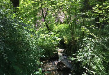
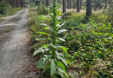
Tour Pfad von 6,2 km verfügbar auf Wallonien, Namur, Somme-Leuze. Diese Tour wird von daniel_2w vorgeschlagen.
Beschreibung
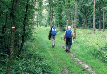
Ce parcours évolue dans la magnifique région de Somme-Leuze, autour du village de Heure-en-Famenne, entre routes de campagnes et chemins boisés. Un sentier très pentu dans le bois de Heure
Ort
Land:
Belgium
Region :
Wallonien
Abteilung/Provinz :
Namur
Kommune :
Somme-Leuze
Standort:
Heure
Gehen Sie:(Dec)
Gehen Sie:(UTM)
663524 ; 5573899 (31U) N.
Kommentare
Touren in der Umgebung
![Tour Wandern Somme-Leuze - RB-Na-04 - Balade aux sources de la Somme - Photo](https://media.geolcdn.com/t/375/260/ext.jpg?maxdim=2&url=https%3A%2F%2Fservices.sitytrail.com%2FGeolivesWS%2FDownloadMedia.ashx%3FTrailID%3D179630%26Media%3D2ccb572a-0d57-4973-8026-20e9cbf116e6.jpg)
![Wandern Wandern](https://static1.geolcdn.com/sitytour/trail-icons/101.png)
RB-Na-04 - Balade aux sources de la Somme
Wandern
Medium
(14)
Somme-Leuze,
Wallonien,
Namur,
Belgium
![](/images/other/stat-length.png)
22 km | 28 km-effort
6h 0min
![](https://static1.geolcdn.com/siteimages/upload/files/16400158638029165_repeat_loop_refresh_sync_direction_icon.png)
Ja
![Tour Wandern Somme-Leuze - Sentiers d'Art : Boucle16 - Somal - Photo](https://media.geolcdn.com/t/375/260/ext.jpg?maxdim=2&url=https%3A%2F%2Fmedia.geolcdn.com%2Ff%2Feae3e58a-34ce-48df-b7e8-8306bccbd31f.JPG)
![Wandern Wandern](https://static1.geolcdn.com/sitytour/trail-icons/101.png)
Sentiers d'Art : Boucle16 - Somal
Wandern
Medium
(5)
Somme-Leuze,
Wallonien,
Namur,
Belgium
![](/images/other/stat-length.png)
7,4 km | 9,9 km-effort
2h 7min
![](https://static1.geolcdn.com/siteimages/upload/files/16400158638029165_repeat_loop_refresh_sync_direction_icon.png)
Ja
![Tour Wandern Somme-Leuze - RB-Na-04 Raccourci - Balade aux sources de la Somme - Photo](https://media.geolcdn.com/t/375/260/ext.jpg?maxdim=2&url=https%3A%2F%2Fservices.sitytrail.com%2FGeolivesWS%2FDownloadMedia.ashx%3FTrailID%3D252171%26Media%3Dc5d56e41-95c8-4990-91cc-1ec916893014.jpg)
![Wandern Wandern](https://static1.geolcdn.com/sitytour/trail-icons/101.png)
RB-Na-04 Raccourci - Balade aux sources de la Somme
Wandern
Einfach
(6)
Somme-Leuze,
Wallonien,
Namur,
Belgium
![](/images/other/stat-length.png)
18,7 km | 24 km-effort
5h 3min
![](https://static1.geolcdn.com/siteimages/upload/files/16400158638029165_repeat_loop_refresh_sync_direction_icon.png)
Ja
![Tour Zu Fuß Somme-Leuze - Sentiers d'Art : Boucle 17 - Heure - Photo](https://media.geolcdn.com/t/375/260/ext.jpg?maxdim=2&url=https%3A%2F%2Fmedia.geolcdn.com%2Ff%2Fd3b600c0-617d-4b9c-b782-c930c89e279c.jpg)
![Zu Fuß Zu Fuß](https://static1.geolcdn.com/sitytour/trail-icons/100.png)
Sentiers d'Art : Boucle 17 - Heure
Zu Fuß
Medium
(2)
Somme-Leuze,
Wallonien,
Namur,
Belgium
![](/images/other/stat-length.png)
15,9 km | 20 km-effort
4h 33min
![](https://static1.geolcdn.com/siteimages/upload/files/16400158638029165_repeat_loop_refresh_sync_direction_icon.png)
Ja
![Tour Wandern Havelange - HAVELANGE- Failon- Promenade du Chêne au Gibet - Photo](https://media.geolcdn.com/t/375/260/ext.jpg?maxdim=2&url=https%3A%2F%2Fservices.sitytrail.com%2FGeolivesWS%2FDownloadMedia.ashx%3FTrailID%3D250680%26Media%3D5b284e0f-4186-471a-9bbe-220cdacf1b74.jpg)
![Wandern Wandern](https://static1.geolcdn.com/sitytour/trail-icons/101.png)
HAVELANGE- Failon- Promenade du Chêne au Gibet
Wandern
Sehr leicht
(5)
Havelange,
Wallonien,
Namur,
Belgium
![](/images/other/stat-length.png)
15,8 km | 20 km-effort
4h 17min
![](https://static1.geolcdn.com/siteimages/upload/files/16400158638029165_repeat_loop_refresh_sync_direction_icon.png)
Ja
![Tour Wandern Havelange - FAILON (Château-Ferme de Somal) - Photo](https://media.geolcdn.com/t/375/260/ext.jpg?maxdim=2&url=https%3A%2F%2Fservices.sitytrail.com%2FGeolivesWS%2FDownloadMedia.ashx%3FTrailID%3D1004822%26Media%3Dfix__20180712160140.jpg)
![Wandern Wandern](https://static1.geolcdn.com/sitytour/trail-icons/101.png)
FAILON (Château-Ferme de Somal)
Wandern
Einfach
(3)
Havelange,
Wallonien,
Namur,
Belgium
![](/images/other/stat-length.png)
10,7 km | 14,2 km-effort
3h 1min
![](https://static1.geolcdn.com/siteimages/upload/files/16400158638029165_repeat_loop_refresh_sync_direction_icon.png)
Ja
![Tour Wandern Havelange - Bois, Rivière et champs - Photo](https://media.geolcdn.com/t/375/260/ext.jpg?maxdim=2&url=https%3A%2F%2Fmedia.geolcdn.com%2Ff%2F71798de8-0a71-47ba-81bf-636f8514053b.jpg)
![Wandern Wandern](https://static1.geolcdn.com/sitytour/trail-icons/101.png)
Bois, Rivière et champs
Wandern
Medium
(3)
Havelange,
Wallonien,
Namur,
Belgium
![](/images/other/stat-length.png)
9,3 km | 12,2 km-effort
3h 8min
![](https://static1.geolcdn.com/siteimages/upload/files/16400158638029165_repeat_loop_refresh_sync_direction_icon.png)
Ja
![Tour Zu Fuß Havelange - Promenade du Bois de Porcheresse - Photo](https://media.geolcdn.com/t/375/260/ext.jpg?maxdim=2&url=https%3A%2F%2Fpivotmedia.tourismewallonie.be%2FOTH-A0-0035-12HV%2FOTH-A0-0035-12HV.jpg)
![Zu Fuß Zu Fuß](https://static1.geolcdn.com/sitytour/trail-icons/100.png)
Promenade du Bois de Porcheresse
Zu Fuß
Einfach
(2)
Havelange,
Wallonien,
Namur,
Belgium
![](/images/other/stat-length.png)
7,2 km | 8,8 km-effort
2h 0min
![](https://static1.geolcdn.com/siteimages/upload/files/16400158638029165_repeat_loop_refresh_sync_direction_icon.png)
Ja
![Tour Zu Fuß Havelange - Balade du Chêne au Gibet - Photo](https://media.geolcdn.com/t/375/260/ext.jpg?maxdim=2&url=https%3A%2F%2Fpivotmedia.tourismewallonie.be%2FOTH-A0-0031-0XZ0%2FOTH-A0-0031-0XZ0.jpg)
![Zu Fuß Zu Fuß](https://static1.geolcdn.com/sitytour/trail-icons/100.png)
Balade du Chêne au Gibet
Zu Fuß
Medium
Havelange,
Wallonien,
Namur,
Belgium
![](/images/other/stat-length.png)
15,8 km | 20 km-effort
4h 38min
![](https://static1.geolcdn.com/siteimages/upload/files/16400158638029165_repeat_loop_refresh_sync_direction_icon.png)
Ja