![](/images/other/stat-length.png)
![Tour Wandern Libramont-Chevigny - SityTrail - Entre Lesse et Lomme - Photo](https://media.geolcdn.com/t/1900/400/ext.pjpeg?maxdim=2&url=https%3A%2F%2Fstatic1.geolcdn.com%2Fsiteimages%2Fupload%2Ffiles%2F1553511878bg_sport_marche.png)
SityTrail - Entre Lesse et Lomme
ramagufa
Benutzer
![Länge](/images/other/stat-length.png)
Länge
49 km
![Maximale Höhe](https://static1.geolcdn.com/siteimages/upload/files/1508320355ic_sort_altitude_max_24dp.png)
Maximale Höhe
554 m
![Positive Höhendifferenz](https://static1.geolcdn.com/siteimages/upload/files/1508320355ic_sort_den_pos_24dp.png)
Positive Höhendifferenz
805 m
![Km-Effort](/images/other/stat-length.png)
Km-Effort
60 km
![Min. Höhe](https://static1.geolcdn.com/siteimages/upload/files/1508320355ic_sort_altitude_min_24dp.png)
Min. Höhe
150 m
![Negative Höhendifferenz](https://static1.geolcdn.com/siteimages/upload/files/1508320355ic_sort_den_neg_24dp.png)
Negative Höhendifferenz
1119 m
![Boucle](https://static1.geolcdn.com/siteimages/upload/files/16400158638029165_repeat_loop_refresh_sync_direction_icon.png)
Boucle
Nein
Erstellungsdatum :
2019-10-31 15:58:31.278
Letzte Änderung :
2021-05-20 17:43:35.227
![Wandern](https://static1.geolcdn.com/sitytour/trail-icons/101.png)
22h48
Schwierigkeit : Schwierig
![Scannen Sie diesen QR-Code, um die Tour in der SityTrail-Anwendung zu öffnen](https://capi.geolives.com/qq0zvz2zws4bq2lad0pu/sitytour/trails/2254685/qr.png?size=200)
Kostenlosegpshiking-Anwendung
Über SityTrail
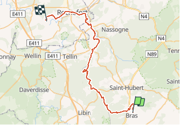
Tour Wandern von 49 km verfügbar auf Wallonien, Luxemburg, Libramont-Chevigny. Diese Tour wird von ramagufa vorgeschlagen.
Beschreibung
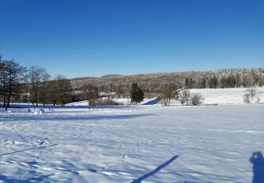
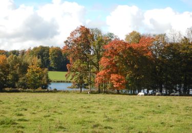
Rando au départ même de la source de la Lomme. (Pas très loin de la chapelle de Lommal)
La première partir du parcours ne se rapproche pas trop d'elle. Il faut compter plus ou moins 10 km avant de pouvoir la longer un peu mieux.
Ort
Land:
Belgium
Region :
Wallonien
Abteilung/Provinz :
Luxemburg
Kommune :
Libramont-Chevigny
Standort:
Unknown
Gehen Sie:(Dec)
Gehen Sie:(UTM)
671375 ; 5539288 (31U) N.
Kommentare
Touren in der Umgebung
![Tour Wandern Saint-Hubert - Hatrival - Banalbois (SH13) - Photo](https://media.geolcdn.com/t/375/260/ext.jpg?maxdim=2&url=https%3A%2F%2Fservices.sitytrail.com%2FGeolivesWS%2FDownloadMedia.ashx%3FTrailID%3D334467%26Media%3D16828998-416a-43a0-960f-95ce479e5d6d.jpg)
![Wandern Wandern](https://static1.geolcdn.com/sitytour/trail-icons/101.png)
Hatrival - Banalbois (SH13)
Wandern
Medium
(6)
Saint-Hubert,
Wallonien,
Luxemburg,
Belgium
![](/images/other/stat-length.png)
7,5 km | 9,5 km-effort
2h 2min
![](https://static1.geolcdn.com/siteimages/upload/files/16400158638029165_repeat_loop_refresh_sync_direction_icon.png)
Ja
![Tour Wandern Saint-Hubert - Vesqueville - Vesqueville (SH09) - Photo](https://media.geolcdn.com/t/375/260/ext.jpg?maxdim=2&url=https%3A%2F%2Fservices.sitytrail.com%2FGeolivesWS%2FDownloadMedia.ashx%3FTrailID%3D334610%26Media%3D79c980a9-bd48-4f1e-9150-6b805f1400ff.jpg)
![Wandern Wandern](https://static1.geolcdn.com/sitytour/trail-icons/101.png)
Vesqueville - Vesqueville (SH09)
Wandern
Schwierig
(6)
Saint-Hubert,
Wallonien,
Luxemburg,
Belgium
![](/images/other/stat-length.png)
15,6 km | 19,4 km-effort
4h 9min
![](https://static1.geolcdn.com/siteimages/upload/files/16400158638029165_repeat_loop_refresh_sync_direction_icon.png)
Ja
![Tour Wandern Libramont-Chevigny - Marche ADEPS à Séviscourt. - Photo](https://media.geolcdn.com/t/375/260/a1af7c4b-992e-4843-a6a5-dfa52ee754c1.jpg&format=jpg&maxdim=2)
![Wandern Wandern](https://static1.geolcdn.com/sitytour/trail-icons/101.png)
Marche ADEPS à Séviscourt.
Wandern
Einfach
(1)
Libramont-Chevigny,
Wallonien,
Luxemburg,
Belgium
![](/images/other/stat-length.png)
10,3 km | 13,5 km-effort
2h 8min
![](https://static1.geolcdn.com/siteimages/upload/files/16400158638029165_repeat_loop_refresh_sync_direction_icon.png)
Ja
![Tour Wandern Saint-Hubert - ADEPS Saint Hubert - Photo](https://media.geolcdn.com/t/375/260/018b420c-08b1-4fdb-919c-55acbcd603df.jpg&format=jpg&maxdim=2)
![Wandern Wandern](https://static1.geolcdn.com/sitytour/trail-icons/101.png)
ADEPS Saint Hubert
Wandern
Schwierig
(1)
Saint-Hubert,
Wallonien,
Luxemburg,
Belgium
![](/images/other/stat-length.png)
10,8 km | 13,7 km-effort
1h 57min
![](https://static1.geolcdn.com/siteimages/upload/files/16400158638029165_repeat_loop_refresh_sync_direction_icon.png)
Ja
![Wandern Wandern](https://static1.geolcdn.com/sitytour/trail-icons/101.png)
RB-Lu-22_Flohimont_via-var
Wandern
Sehr schwierig
(1)
Libramont-Chevigny,
Wallonien,
Luxemburg,
Belgium
![](/images/other/stat-length.png)
30 km | 37 km-effort
8h 30min
![](https://static1.geolcdn.com/siteimages/upload/files/16400158638029165_repeat_loop_refresh_sync_direction_icon.png)
Ja
![Wandern Wandern](https://static1.geolcdn.com/sitytour/trail-icons/101.png)
RB-Lu-22_Flohimont
Wandern
Sehr leicht
(1)
Libramont-Chevigny,
Wallonien,
Luxemburg,
Belgium
![](/images/other/stat-length.png)
28 km | 35 km-effort
7h 21min
![](https://static1.geolcdn.com/siteimages/upload/files/16400158638029165_repeat_loop_refresh_sync_direction_icon.png)
Ja
![Tour Wandern Saint-Hubert - VESQUEVILLE ... les bois de Sârwé. - Photo](https://media.geolcdn.com/t/375/260/9cdca503-557b-4f6e-8bb6-2c9e1494722a.jpg&format=jpg&maxdim=2)
![Wandern Wandern](https://static1.geolcdn.com/sitytour/trail-icons/101.png)
VESQUEVILLE ... les bois de Sârwé.
Wandern
Einfach
(1)
Saint-Hubert,
Wallonien,
Luxemburg,
Belgium
![](/images/other/stat-length.png)
10 km | 12,3 km-effort
2h 27min
![](https://static1.geolcdn.com/siteimages/upload/files/16400158638029165_repeat_loop_refresh_sync_direction_icon.png)
Ja
![Wandern Wandern](https://static1.geolcdn.com/sitytour/trail-icons/101.png)
RB-Lu-22_Flohimont_via-racc
Wandern
Sehr leicht
(1)
Libramont-Chevigny,
Wallonien,
Luxemburg,
Belgium
![](/images/other/stat-length.png)
21 km | 25 km-effort
1h 42min
![](https://static1.geolcdn.com/siteimages/upload/files/16400158638029165_repeat_loop_refresh_sync_direction_icon.png)
Ja
![Tour Wandern Saint-Hubert - Hatrival - Hatrival (SH11) - Photo](https://media.geolcdn.com/t/375/260/ext.jpg?maxdim=2&url=https%3A%2F%2Fservices.sitytrail.com%2FGeolivesWS%2FDownloadMedia.ashx%3FTrailID%3D334445%26Media%3D0f06cf58-f0eb-4df9-9750-5fbe487dabd3.jpg)
![Wandern Wandern](https://static1.geolcdn.com/sitytour/trail-icons/101.png)
Hatrival - Hatrival (SH11)
Wandern
Medium
(3)
Saint-Hubert,
Wallonien,
Luxemburg,
Belgium
![](/images/other/stat-length.png)
7,4 km | 9,3 km-effort
1h 59min
![](https://static1.geolcdn.com/siteimages/upload/files/16400158638029165_repeat_loop_refresh_sync_direction_icon.png)
Ja