![](/images/other/stat-length.png)
![Tour Reiten Viroinval - Olloy - Le Mesnil - Oignies- Olloy - Photo](https://media.geolcdn.com/t/1900/400/ext.pjpeg?maxdim=2&url=https%3A%2F%2Fstatic1.geolcdn.com%2Fsiteimages%2Fupload%2Ffiles%2F1524743154cheval.jpg)
Olloy - Le Mesnil - Oignies- Olloy
tidam
Benutzer
![Länge](/images/other/stat-length.png)
Länge
29 km
![Maximale Höhe](https://static1.geolcdn.com/siteimages/upload/files/1508320355ic_sort_altitude_max_24dp.png)
Maximale Höhe
374 m
![Positive Höhendifferenz](https://static1.geolcdn.com/siteimages/upload/files/1508320355ic_sort_den_pos_24dp.png)
Positive Höhendifferenz
612 m
![Km-Effort](/images/other/stat-length.png)
Km-Effort
37 km
![Min. Höhe](https://static1.geolcdn.com/siteimages/upload/files/1508320355ic_sort_altitude_min_24dp.png)
Min. Höhe
150 m
![Negative Höhendifferenz](https://static1.geolcdn.com/siteimages/upload/files/1508320355ic_sort_den_neg_24dp.png)
Negative Höhendifferenz
613 m
![Boucle](https://static1.geolcdn.com/siteimages/upload/files/16400158638029165_repeat_loop_refresh_sync_direction_icon.png)
Boucle
Ja
Erstellungsdatum :
2019-10-29 13:54:39.986
Letzte Änderung :
2019-11-11 10:44:10.159
![Reiten](https://static1.geolcdn.com/sitytour/trail-icons/301.png)
4h42
Schwierigkeit : Schwierig
![Scannen Sie diesen QR-Code, um die Tour in der SityTrail-Anwendung zu öffnen](https://capi.geolives.com/qq0zvz2zws4bq2lad0pu/sitytour/trails/2253045/qr.png?size=200)
Kostenlosegpshiking-Anwendung
Über SityTrail
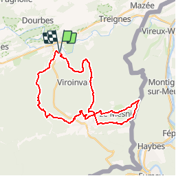
Tour Reiten von 29 km verfügbar auf Wallonien, Namur, Viroinval. Diese Tour wird von tidam vorgeschlagen.
Beschreibung
Grande boucle suivant les plus beaux chemins de la région. Paysages et sols variés. Parking aisé derrière le manège Rolinvaux, lieu de départ des marches nordiques.
Ort
Land:
Belgium
Region :
Wallonien
Abteilung/Provinz :
Namur
Kommune :
Viroinval
Standort:
Olloy-sur-Viroin
Gehen Sie:(Dec)
Gehen Sie:(UTM)
615523 ; 5547680 (31U) N.
Kommentare
Touren in der Umgebung
![Tour Wandern Viroinval - RB-Na-13 Tiennes et vallons de la Calestienne - Photo](https://media.geolcdn.com/t/375/260/ext.jpg?maxdim=2&url=https%3A%2F%2Fservices.sitytrail.com%2FGeolivesWS%2FDownloadMedia.ashx%3FTrailID%3D260747%26Media%3Dff8837a8-8f2b-4db1-ba1e-88015d1f5e8a.jpg)
![Wandern Wandern](https://static1.geolcdn.com/sitytour/trail-icons/101.png)
RB-Na-13 Tiennes et vallons de la Calestienne
Wandern
Medium
(13)
Viroinval,
Wallonien,
Namur,
Belgium
![](/images/other/stat-length.png)
22 km | 28 km-effort
6h 4min
![](https://static1.geolcdn.com/siteimages/upload/files/16400158638029165_repeat_loop_refresh_sync_direction_icon.png)
Ja
![Tour Wandern Viroinval - Balade dans le Viroinval - De Vierves à Olloy - Photo](https://media.geolcdn.com/t/375/260/eea3f008-fef3-4865-8c34-a0378b4c67ed.jpeg&format=jpg&maxdim=2)
![Wandern Wandern](https://static1.geolcdn.com/sitytour/trail-icons/101.png)
Balade dans le Viroinval - De Vierves à Olloy
Wandern
Sehr leicht
(2)
Viroinval,
Wallonien,
Namur,
Belgium
![](/images/other/stat-length.png)
8,9 km | 12,7 km-effort
4h 17min
![](https://static1.geolcdn.com/siteimages/upload/files/16400158638029165_repeat_loop_refresh_sync_direction_icon.png)
Ja
![Tour Wandern Viroinval - RB-Na-12 Ed4 Balade franco-belge chez Toine Culot - Photo](https://media.geolcdn.com/t/375/260/ext.jpg?maxdim=2&url=https%3A%2F%2Fservices.sitytrail.com%2FGeolivesWS%2FDownloadMedia.ashx%3FTrailID%3D794212%26Media%3D5fba0928-65b8-4f08-8244-3dd1e2295f4a.jpg)
![Wandern Wandern](https://static1.geolcdn.com/sitytour/trail-icons/101.png)
RB-Na-12 Ed4 Balade franco-belge chez Toine Culot
Wandern
Medium
(3)
Viroinval,
Wallonien,
Namur,
Belgium
![](/images/other/stat-length.png)
14,8 km | 21 km-effort
6h 13min
![](https://static1.geolcdn.com/siteimages/upload/files/16400158638029165_repeat_loop_refresh_sync_direction_icon.png)
Ja
![Tour Fahrrad Viroinval - À la découverte de Viroinval - Photo](https://media.geolcdn.com/t/375/260/ext.jpg?maxdim=2&url=https%3A%2F%2Fservices.sitytrail.com%2FGeolivesWS%2FDownloadMedia.ashx%3FTrailID%3D551547%26Media%3D1e3b4634-36c4-481a-a49d-2f3fedd5bc9a.JPG)
![Fahrrad Fahrrad](https://static1.geolcdn.com/sitytour/trail-icons/200.png)
À la découverte de Viroinval
Fahrrad
Medium
(1)
Viroinval,
Wallonien,
Namur,
Belgium
![](/images/other/stat-length.png)
28 km | 34 km-effort
1h 58min
![](https://static1.geolcdn.com/siteimages/upload/files/16400158638029165_repeat_loop_refresh_sync_direction_icon.png)
Ja
![Tour Wandern Viroinval - Balade dans le Viroinval - De Vierves à Olloy - Photo](https://media.geolcdn.com/t/375/260/ext.jpg?maxdim=2&url=https%3A%2F%2Fservices.sitytrail.com%2FGeolivesWS%2FDownloadMedia.ashx%3FTrailID%3D394463%26Media%3D8cd58c74-46af-4e33-ad1f-b804c133f48a.JPG)
![Wandern Wandern](https://static1.geolcdn.com/sitytour/trail-icons/101.png)
Balade dans le Viroinval - De Vierves à Olloy
Wandern
Einfach
(1)
Viroinval,
Wallonien,
Namur,
Belgium
![](/images/other/stat-length.png)
10,5 km | 14 km-effort
3h 3min
![](https://static1.geolcdn.com/siteimages/upload/files/16400158638029165_repeat_loop_refresh_sync_direction_icon.png)
Ja
![Tour Wandern Viroinval - Vierves. Natura 2000, des sites qui valent le détour ! Na6 - Photo](https://media.geolcdn.com/t/375/260/ext.jpg?maxdim=2&url=https%3A%2F%2Fservices.sitytrail.com%2FGeolivesWS%2FDownloadMedia.ashx%3FTrailID%3D161505%26Media%3Dd444d70d-cecc-46cd-9982-c53f323c2b51.jpg)
![Wandern Wandern](https://static1.geolcdn.com/sitytour/trail-icons/101.png)
Vierves. Natura 2000, des sites qui valent le détour ! Na6
Wandern
Einfach
(2)
Viroinval,
Wallonien,
Namur,
Belgium
![](/images/other/stat-length.png)
9,7 km | 12,7 km-effort
2h 41min
![](https://static1.geolcdn.com/siteimages/upload/files/16400158638029165_repeat_loop_refresh_sync_direction_icon.png)
Ja
![Tour Mountainbike Viroinval - Vierves - Olloy - Petigny - Nismes - Photo](https://media.geolcdn.com/t/375/260/d0c4d464-3769-46ce-b3d8-dcecdd33235b.jpeg&format=jpg&maxdim=2)
![Mountainbike Mountainbike](https://static1.geolcdn.com/sitytour/trail-icons/202.png)
Vierves - Olloy - Petigny - Nismes
Mountainbike
Schwierig
(1)
Viroinval,
Wallonien,
Namur,
Belgium
![](/images/other/stat-length.png)
34 km | 42 km-effort
2h 9min
![](https://static1.geolcdn.com/siteimages/upload/files/16400158638029165_repeat_loop_refresh_sync_direction_icon.png)
Ja
![Tour Wandern Viroinval - fondry des chiens - Photo](https://media.geolcdn.com/t/375/260/ext.jpg?maxdim=2&url=https%3A%2F%2Fservices.sitytrail.com%2FGeolivesWS%2FDownloadMedia.ashx%3FTrailID%3D629836%26Media%3Dfix__20160911163715.jpg)
![Wandern Wandern](https://static1.geolcdn.com/sitytour/trail-icons/101.png)
fondry des chiens
Wandern
Einfach
(1)
Viroinval,
Wallonien,
Namur,
Belgium
![](/images/other/stat-length.png)
5,3 km | 6,9 km-effort
1h 35min
![](https://static1.geolcdn.com/siteimages/upload/files/16400158638029165_repeat_loop_refresh_sync_direction_icon.png)
Ja
![Tour Nordic Walking Viroinval - VNW - Olloy-sur-viroin - 1 Fond de chênaux - Photo](https://media.geolcdn.com/t/375/260/ext.jpg?maxdim=2&url=https%3A%2F%2Fservices.sitytrail.com%2FGeolivesWS%2FDownloadMedia.ashx%3FTrailID%3D506311%26Media%3Dd545e250-2fab-40c7-9597-5dc8503503aa.jpg)
![Nordic Walking Nordic Walking](https://static1.geolcdn.com/sitytour/trail-icons/102.png)
VNW - Olloy-sur-viroin - 1 Fond de chênaux
Nordic Walking
Medium
(1)
Viroinval,
Wallonien,
Namur,
Belgium
![](/images/other/stat-length.png)
5 km | 6,5 km-effort
1h 3min
![](https://static1.geolcdn.com/siteimages/upload/files/16400158638029165_repeat_loop_refresh_sync_direction_icon.png)
Ja