![](/images/other/stat-length.png)
![Tour Wandern Durban-Corbières - M012-Durban Corbières - Photo](https://media.geolcdn.com/t/1900/400/ext.pjpeg?maxdim=2&url=https%3A%2F%2Fstatic1.geolcdn.com%2Fsiteimages%2Fupload%2Ffiles%2F1553511878bg_sport_marche.png)
M012-Durban Corbières
Polo-31
Benutzer
![Länge](/images/other/stat-length.png)
Länge
12,1 km
![Maximale Höhe](https://static1.geolcdn.com/siteimages/upload/files/1508320355ic_sort_altitude_max_24dp.png)
Maximale Höhe
372 m
![Positive Höhendifferenz](https://static1.geolcdn.com/siteimages/upload/files/1508320355ic_sort_den_pos_24dp.png)
Positive Höhendifferenz
475 m
![Km-Effort](/images/other/stat-length.png)
Km-Effort
18,5 km
![Min. Höhe](https://static1.geolcdn.com/siteimages/upload/files/1508320355ic_sort_altitude_min_24dp.png)
Min. Höhe
93 m
![Negative Höhendifferenz](https://static1.geolcdn.com/siteimages/upload/files/1508320355ic_sort_den_neg_24dp.png)
Negative Höhendifferenz
477 m
![Boucle](https://static1.geolcdn.com/siteimages/upload/files/16400158638029165_repeat_loop_refresh_sync_direction_icon.png)
Boucle
Ja
Erstellungsdatum :
2014-12-10 00:00:00.0
Letzte Änderung :
2014-12-10 00:00:00.0
![Wandern](https://static1.geolcdn.com/sitytour/trail-icons/101.png)
3h49
Schwierigkeit : Medium
![Scannen Sie diesen QR-Code, um die Tour in der SityTrail-Anwendung zu öffnen](https://capi.geolives.com/qq0zvz2zws4bq2lad0pu/sitytour/trails/225067/qr.png?size=200)
Kostenlosegpshiking-Anwendung
Über SityTrail
Tour Wandern von 12,1 km verfügbar auf Okzitanien, Aude, Durban-Corbières. Diese Tour wird von Polo-31 vorgeschlagen.
Beschreibung
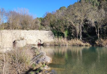
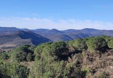
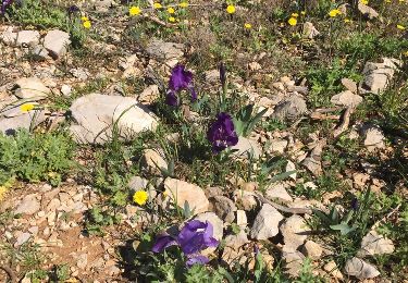
Depuis Durban, Mont Marquié, La Berrière, Pech Bedel, Les Cremades, puis chemin cathare vers Ste Raphine (376m) et retour Durban par le chemin Cathare.
Ort
Land:
France
Region :
Okzitanien
Abteilung/Provinz :
Aude
Kommune :
Durban-Corbières
Standort:
Unknown
Gehen Sie:(Dec)
Gehen Sie:(UTM)
485073 ; 4760427 (31T) N.
Kommentare
Touren in der Umgebung
![Tour Wandern Villeneuve-les-Corbières - La Récaoufa ou Ste Raphine - Photo](https://media.geolcdn.com/t/375/260/ext.jpg?maxdim=2&url=https%3A%2F%2Fservices.sitytrail.com%2FGeolivesWS%2FDownloadMedia.ashx%3FTrailID%3D1091684%26Media%3Dfix__20190103150031.jpg)
![Wandern Wandern](https://static1.geolcdn.com/sitytour/trail-icons/101.png)
La Récaoufa ou Ste Raphine
Wandern
Medium
(1)
Villeneuve-les-Corbières,
Okzitanien,
Aude,
France
![](/images/other/stat-length.png)
19 km | 27 km-effort
5h 37min
![](https://static1.geolcdn.com/siteimages/upload/files/16400158638029165_repeat_loop_refresh_sync_direction_icon.png)
Ja
![Tour Wandern Cascastel-des-Corbières - La Source de la Berre - Cascastel des Corbières - Photo](https://media.geolcdn.com/t/375/260/ext.jpg?maxdim=2&url=https%3A%2F%2Fservices.sitytrail.com%2FGeolivesWS%2FDownloadMedia.ashx%3FTrailID%3D317734%26Media%3D17045_4.jpg)
![Wandern Wandern](https://static1.geolcdn.com/sitytour/trail-icons/101.png)
La Source de la Berre - Cascastel des Corbières
Wandern
Medium
(1)
Cascastel-des-Corbières,
Okzitanien,
Aude,
France
![](/images/other/stat-length.png)
16 km | 21 km-effort
4h 30min
![](https://static1.geolcdn.com/siteimages/upload/files/16400158638029165_repeat_loop_refresh_sync_direction_icon.png)
Ja
![Tour Esel-Trekking Durban-Corbières - Cathare 2 de Durban à Tuchan - Photo](https://media.geolcdn.com/t/375/260/6fe1b779-96fe-4d4f-a201-649aafa8ed1c.jpg&format=jpg&maxdim=2)
![Esel-Trekking Esel-Trekking](https://static1.geolcdn.com/sitytour/trail-icons/303.png)
Cathare 2 de Durban à Tuchan
Esel-Trekking
Medium
Durban-Corbières,
Okzitanien,
Aude,
France
![](/images/other/stat-length.png)
28 km | 39 km-effort
6h 50min
![](https://static1.geolcdn.com/siteimages/upload/files/16400158638029165_repeat_loop_refresh_sync_direction_icon.png)
Nein
![Tour Wandern Durban-Corbières - M020-Durban Corbières - Photo](https://media.geolcdn.com/t/375/260/ext.jpg?maxdim=2&url=https%3A%2F%2Fservices.sitytrail.com%2FGeolivesWS%2FDownloadMedia.ashx%3FTrailID%3D230536%26Media%3Dfix__20131102152153.jpg)
![Wandern Wandern](https://static1.geolcdn.com/sitytour/trail-icons/101.png)
M020-Durban Corbières
Wandern
Medium
Durban-Corbières,
Okzitanien,
Aude,
France
![](/images/other/stat-length.png)
19,7 km | 28 km-effort
5h 50min
![](https://static1.geolcdn.com/siteimages/upload/files/16400158638029165_repeat_loop_refresh_sync_direction_icon.png)
Ja
![Tour Wandern Durban-Corbières - M014-Durban Corbières - Photo](https://media.geolcdn.com/t/375/260/ext.jpg?maxdim=2&url=https%3A%2F%2Fservices.sitytrail.com%2FGeolivesWS%2FDownloadMedia.ashx%3FTrailID%3D230366%26Media%3Dfix__20131101180029.jpg)
![Wandern Wandern](https://static1.geolcdn.com/sitytour/trail-icons/101.png)
M014-Durban Corbières
Wandern
Medium
Durban-Corbières,
Okzitanien,
Aude,
France
![](/images/other/stat-length.png)
13,4 km | 18,1 km-effort
3h 48min
![](https://static1.geolcdn.com/siteimages/upload/files/16400158638029165_repeat_loop_refresh_sync_direction_icon.png)
Ja
![Tour Wandern Villesèque-des-Corbières - 5-02 - Photo](https://media.geolcdn.com/t/375/260/e4d078e0-a8e8-4a1c-a1aa-7274460c4b02.jpg&format=jpg&maxdim=2)
![Wandern Wandern](https://static1.geolcdn.com/sitytour/trail-icons/101.png)
5-02
Wandern
Sehr schwierig
Villesèque-des-Corbières,
Okzitanien,
Aude,
France
![](/images/other/stat-length.png)
19,8 km | 26 km-effort
4h 59min
![](https://static1.geolcdn.com/siteimages/upload/files/16400158638029165_repeat_loop_refresh_sync_direction_icon.png)
Ja
![Tour Wandern Cascastel-des-Corbières - 29-01 - Photo](https://media.geolcdn.com/t/375/260/c9934ba2-d4d0-4b78-8fd2-0165e3f5a07d.jpg&format=jpg&maxdim=2)
![Wandern Wandern](https://static1.geolcdn.com/sitytour/trail-icons/101.png)
29-01
Wandern
Sehr schwierig
Cascastel-des-Corbières,
Okzitanien,
Aude,
France
![](/images/other/stat-length.png)
16,7 km | 23 km-effort
4h 3min
![](https://static1.geolcdn.com/siteimages/upload/files/16400158638029165_repeat_loop_refresh_sync_direction_icon.png)
Ja
![Tour Wandern Villeneuve-les-Corbières - Villeneuve des corbières - Photo](https://media.geolcdn.com/t/375/260/ext.jpg?maxdim=2&url=https%3A%2F%2Fservices.sitytrail.com%2FGeolivesWS%2FDownloadMedia.ashx%3FTrailID%3D723475%26Media%3D20170330123240.jpg)
![Wandern Wandern](https://static1.geolcdn.com/sitytour/trail-icons/101.png)
Villeneuve des corbières
Wandern
Medium
Villeneuve-les-Corbières,
Okzitanien,
Aude,
France
![](/images/other/stat-length.png)
19,9 km | 29 km-effort
5h 28min
![](https://static1.geolcdn.com/siteimages/upload/files/16400158638029165_repeat_loop_refresh_sync_direction_icon.png)
Ja
![Tour Wandern Durban-Corbières - M014-Durban Corbières - Photo](https://media.geolcdn.com/t/375/260/ext.jpg?maxdim=2&url=https%3A%2F%2Fservices.sitytrail.com%2FGeolivesWS%2FDownloadMedia.ashx%3FTrailID%3D663419%26Media%3D9e67e662-a45b-48c9-961a-5456e0ec1c89.jpg)
![Wandern Wandern](https://static1.geolcdn.com/sitytour/trail-icons/101.png)
M014-Durban Corbières
Wandern
Medium
Durban-Corbières,
Okzitanien,
Aude,
France
![](/images/other/stat-length.png)
13,4 km | 18,1 km-effort
3h 48min
![](https://static1.geolcdn.com/siteimages/upload/files/16400158638029165_repeat_loop_refresh_sync_direction_icon.png)
Ja
Très beau parcours mais dommage que le sentier soit presque complètement obstrué par endroit entre le km 3 et le km 4 mais on peut l'éviter en prenant la piste par la cote 185 puis 280 et 282, il en est de même au Km 5 où nous n'avons pas trouvé le chemin sur la droite, nous avons alors rejoint le km 6 en passant par montaut, très joli sentier également