![](/images/other/stat-length.png)
![Tour Wandern Aigaliers - Aigaliers, le Chabian et Bourdiguet - Photo](https://media.geolcdn.com/t/1900/400/ext.pjpeg?maxdim=2&url=https%3A%2F%2Fstatic1.geolcdn.com%2Fsiteimages%2Fupload%2Ffiles%2F1553511878bg_sport_marche.png)
Aigaliers, le Chabian et Bourdiguet
randotines
Benutzer GUIDE
![Länge](/images/other/stat-length.png)
![Maximale Höhe](https://static1.geolcdn.com/siteimages/upload/files/1508320355ic_sort_altitude_max_24dp.png)
![Positive Höhendifferenz](https://static1.geolcdn.com/siteimages/upload/files/1508320355ic_sort_den_pos_24dp.png)
![Km-Effort](/images/other/stat-length.png)
![Min. Höhe](https://static1.geolcdn.com/siteimages/upload/files/1508320355ic_sort_altitude_min_24dp.png)
![Negative Höhendifferenz](https://static1.geolcdn.com/siteimages/upload/files/1508320355ic_sort_den_neg_24dp.png)
![Boucle](https://static1.geolcdn.com/siteimages/upload/files/16400158638029165_repeat_loop_refresh_sync_direction_icon.png)
![Wandern](https://static1.geolcdn.com/sitytour/trail-icons/101.png)
3h24
Schwierigkeit : Medium
![Scannen Sie diesen QR-Code, um die Tour in der SityTrail-Anwendung zu öffnen](https://capi.geolives.com/qq0zvz2zws4bq2lad0pu/sitytour/trails/224505/qr.png?size=200)
Kostenlosegpshiking-Anwendung
Über SityTrail
Tour Wandern von 17,8 km verfügbar auf Okzitanien, Gard, Aigaliers. Diese Tour wird von randotines vorgeschlagen.
Beschreibung
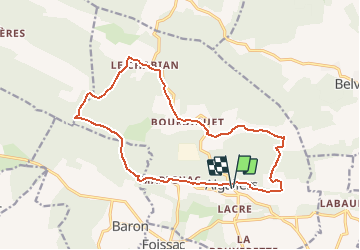
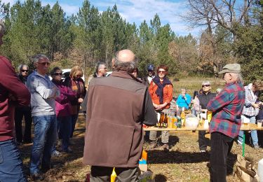
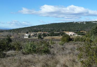
Belle rando de 18 km au départ d'Aigaliers ( Gard ) avec passage par la combe de Pousselargues, le village de Bourdiguet,le hameau du Chabian puis descente vers la combe de Vallongue et le centre de recherche expérimentale d'architecture écologique..retour par le fond du vallon à la fraiche vers sous Dève et les Ponts de Tardre, Marignac et retour sur Aigaliers par la D267 puis par un sentier passant derrière St Martin.
Ort
Kommentare
Touren in der Umgebung
![Tour Wandern Serviers-et-Labaume - servers labame 2012 - Photo](https://media.geolcdn.com/t/375/260/ext.jpg?maxdim=2&url=https%3A%2F%2Fstatic1.geolcdn.com%2Fsiteimages%2Fupload%2Ffiles%2F1553511878bg_sport_marche.png)
![Wandern Wandern](https://static1.geolcdn.com/sitytour/trail-icons/101.png)
Wandern
![](/images/other/stat-length.png)
![](https://static1.geolcdn.com/siteimages/upload/files/16400158638029165_repeat_loop_refresh_sync_direction_icon.png)
![Tour Wandern Belvézet - Autour du Mas de l'ancienne église - Photo](https://media.geolcdn.com/t/375/260/09c6bc09-8ddc-4e77-b2f3-b76dc4d1de9e.jpg&format=jpg&maxdim=2)
![Wandern Wandern](https://static1.geolcdn.com/sitytour/trail-icons/101.png)
Wandern
![](/images/other/stat-length.png)
![](https://static1.geolcdn.com/siteimages/upload/files/16400158638029165_repeat_loop_refresh_sync_direction_icon.png)
![Tour Wandern Belvézet - Belvédère - Photo](https://media.geolcdn.com/t/375/260/27d01b8c-cd56-47f4-8b45-e0d7b0e0b71a.jpg&format=jpg&maxdim=2)
![Wandern Wandern](https://static1.geolcdn.com/sitytour/trail-icons/101.png)
Wandern
![](/images/other/stat-length.png)
![](https://static1.geolcdn.com/siteimages/upload/files/16400158638029165_repeat_loop_refresh_sync_direction_icon.png)
![Tour Wandern Serviers-et-Labaume - servers labame 2012 - Photo](https://media.geolcdn.com/t/375/260/ext.jpg?maxdim=2&url=https%3A%2F%2Fstatic1.geolcdn.com%2Fsiteimages%2Fupload%2Ffiles%2F1553511878bg_sport_marche.png)
![Wandern Wandern](https://static1.geolcdn.com/sitytour/trail-icons/101.png)
Wandern
![](/images/other/stat-length.png)
![](https://static1.geolcdn.com/siteimages/upload/files/16400158638029165_repeat_loop_refresh_sync_direction_icon.png)
![Tour Zu Fuß Belvézet - MONTEILLET - Photo](https://media.geolcdn.com/t/375/260/4971cba2-da85-4a64-99de-1689819e6ab4.jpeg&format=jpg&maxdim=2)
![Zu Fuß Zu Fuß](https://static1.geolcdn.com/sitytour/trail-icons/100.png)
![Tour Wandern Serviers-et-Labaume - serviers - Photo](https://media.geolcdn.com/t/375/260/72c8dcb8-6a81-45f9-bdef-aca980ac6cd7.jpg&format=jpg&maxdim=2)
![Wandern Wandern](https://static1.geolcdn.com/sitytour/trail-icons/101.png)
Wandern
![](/images/other/stat-length.png)
![](https://static1.geolcdn.com/siteimages/upload/files/16400158638029165_repeat_loop_refresh_sync_direction_icon.png)
![Tour Andere Aktivitäten Aigaliers - aigaliers - Photo](https://media.geolcdn.com/t/375/260/ext.jpg?maxdim=2&url=https%3A%2F%2Fstatic1.geolcdn.com%2Fsiteimages%2Fupload%2Ffiles%2F1545311037marcheuse_200dpi.jpg)
![Andere Aktivitäten Andere Aktivitäten](https://static1.geolcdn.com/sitytour/trail-icons/900.png)
Andere Aktivitäten
![](/images/other/stat-length.png)
![](https://static1.geolcdn.com/siteimages/upload/files/16400158638029165_repeat_loop_refresh_sync_direction_icon.png)
![Tour Wandern Foissac - L'Arque de Baron - Foissac - Photo](https://media.geolcdn.com/t/375/260/ext.jpg?maxdim=2&url=https%3A%2F%2Fservices.sitytrail.com%2FGeolivesWS%2FDownloadMedia.ashx%3FTrailID%3D191337%26Media%3D14894_5.jpg)
![Wandern Wandern](https://static1.geolcdn.com/sitytour/trail-icons/101.png)
Wandern
![](/images/other/stat-length.png)
![](https://static1.geolcdn.com/siteimages/upload/files/16400158638029165_repeat_loop_refresh_sync_direction_icon.png)
![Tour Wandern Serviers-et-Labaume - Randonnée en forêt de Massargues et vallée du Bourdic - Serviers et Labaume - Photo](https://media.geolcdn.com/t/375/260/ext.jpg?maxdim=2&url=https%3A%2F%2Fservices.sitytrail.com%2FGeolivesWS%2FDownloadMedia.ashx%3FTrailID%3D191336%26Media%3D14893_6.jpg)
![Wandern Wandern](https://static1.geolcdn.com/sitytour/trail-icons/101.png)
Wandern
![](/images/other/stat-length.png)
![](https://static1.geolcdn.com/siteimages/upload/files/16400158638029165_repeat_loop_refresh_sync_direction_icon.png)