![](/images/other/stat-length.png)
![Tour Mountainbike Saint-Nicolas-de-Bourgueil - Zevtt - Bourgueil 65 km - Photo](https://media.geolcdn.com/t/1900/400/ext.pjpeg?maxdim=2&url=https%3A%2F%2Fstatic1.geolcdn.com%2Fsiteimages%2Fupload%2Ffiles%2F1524743154velo.jpg)
Zevtt - Bourgueil 65 km
kipoura
Benutzer
![Länge](/images/other/stat-length.png)
![Maximale Höhe](https://static1.geolcdn.com/siteimages/upload/files/1508320355ic_sort_altitude_max_24dp.png)
![Positive Höhendifferenz](https://static1.geolcdn.com/siteimages/upload/files/1508320355ic_sort_den_pos_24dp.png)
![Km-Effort](/images/other/stat-length.png)
![Min. Höhe](https://static1.geolcdn.com/siteimages/upload/files/1508320355ic_sort_altitude_min_24dp.png)
![Negative Höhendifferenz](https://static1.geolcdn.com/siteimages/upload/files/1508320355ic_sort_den_neg_24dp.png)
![Boucle](https://static1.geolcdn.com/siteimages/upload/files/16400158638029165_repeat_loop_refresh_sync_direction_icon.png)
![Mountainbike](https://static1.geolcdn.com/sitytour/trail-icons/202.png)
5h03
Schwierigkeit : Schwierig
![Scannen Sie diesen QR-Code, um die Tour in der SityTrail-Anwendung zu öffnen](https://capi.geolives.com/qq0zvz2zws4bq2lad0pu/sitytour/trails/223767/qr.png?size=200)
Kostenlosegpshiking-Anwendung
Über SityTrail
Tour Mountainbike von 65 km verfügbar auf Zentrum-Loiretal, Indre-et-Loire, Saint-Nicolas-de-Bourgueil. Diese Tour wird von kipoura vorgeschlagen.
Beschreibung
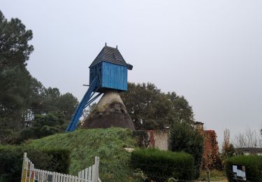
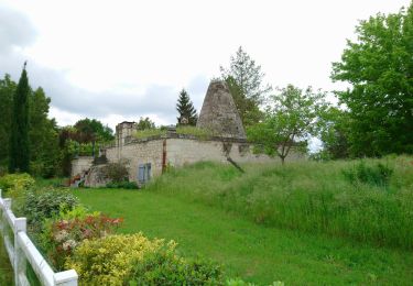
Attention là c'est du lourd. Un circuit VTT au départ de St Nicolas de Bourgueil, passage par les vignes et direction les bois, pour un parcours très ludique et physique. De superbes passages techniques, énormément de relance et de gros raidards à gravir. Condition physique au top pour apprécier à sa juste valeur ce tracé. http://zevtt.free.fr
Ort
Kommentare
Touren in der Umgebung
![Tour Wandern Bourgueil - Bourgueil le Picard - GRP Coteaux de Bourgueil - 24.3km 325m 5h25 (45mn) - 2024 10 30 - Photo](https://media.geolcdn.com/t/375/260/0c109f62-569c-4024-8d89-44f5e325207c.jpg&format=jpg&maxdim=2)
![Wandern Wandern](https://static1.geolcdn.com/sitytour/trail-icons/101.png)
Wandern
![](/images/other/stat-length.png)
![](https://static1.geolcdn.com/siteimages/upload/files/16400158638029165_repeat_loop_refresh_sync_direction_icon.png)
![Tour Wandern Chouzé-sur-Loire - Chouzé-sur-Loire - PRs Varennes-sur-Loire - 23.9km 130m 5h35 (40mn) - 2023 05 08 - Photo](https://media.geolcdn.com/t/375/260/b660d2e9-4397-4a77-a28e-a3fa07c66430.jpg&format=jpg&maxdim=2)
![Wandern Wandern](https://static1.geolcdn.com/sitytour/trail-icons/101.png)
Wandern
![](/images/other/stat-length.png)
![](https://static1.geolcdn.com/siteimages/upload/files/16400158638029165_repeat_loop_refresh_sync_direction_icon.png)
![Tour Wandern Bourgueil - Bourgueil la Grande Prairie - GRP Coteaux de Bourgueil - 26.7km 150m 5h55 (45mn) - 2023 05 06 - Photo](https://media.geolcdn.com/t/375/260/1e477e9a-907b-4338-97bd-cb47fa20dca7.jpg&format=jpg&maxdim=2)
![Wandern Wandern](https://static1.geolcdn.com/sitytour/trail-icons/101.png)
Wandern
![](/images/other/stat-length.png)
![](https://static1.geolcdn.com/siteimages/upload/files/16400158638029165_repeat_loop_refresh_sync_direction_icon.png)
![Tour Wandern Saint-Nicolas-de-Bourgueil - Saint Nicolas de Bourgueil : La forêt et les vignes - Photo](https://media.geolcdn.com/t/375/260/ext.jpg?maxdim=2&url=https%3A%2F%2Fstatic1.geolcdn.com%2Fsiteimages%2Fupload%2Ffiles%2F1553511878bg_sport_marche.png)
![Wandern Wandern](https://static1.geolcdn.com/sitytour/trail-icons/101.png)
Wandern
![](/images/other/stat-length.png)
![](https://static1.geolcdn.com/siteimages/upload/files/16400158638029165_repeat_loop_refresh_sync_direction_icon.png)
![Tour Mountainbike Bourgueil - LA BUTTE A CHÉRON - Photo](https://media.geolcdn.com/t/375/260/ext.jpg?maxdim=2&url=https%3A%2F%2Fstatic1.geolcdn.com%2Fsiteimages%2Fupload%2Ffiles%2F1524743154velo.jpg)
![Mountainbike Mountainbike](https://static1.geolcdn.com/sitytour/trail-icons/202.png)
Mountainbike
![](/images/other/stat-length.png)
![](https://static1.geolcdn.com/siteimages/upload/files/16400158638029165_repeat_loop_refresh_sync_direction_icon.png)
![Tour Wandern Bourgueil - Bourgueil C - Photo](https://media.geolcdn.com/t/375/260/004a2544-d9c9-482b-8c58-f55d05142184.jpg&format=jpg&maxdim=2)
![Wandern Wandern](https://static1.geolcdn.com/sitytour/trail-icons/101.png)
Wandern
![](/images/other/stat-length.png)
![](https://static1.geolcdn.com/siteimages/upload/files/16400158638029165_repeat_loop_refresh_sync_direction_icon.png)
![Tour Wandern Bourgueil - bourgueil 18 - Photo](https://media.geolcdn.com/t/375/260/b6cadb5e-a3e2-49c0-a126-f43c0c663815.jpg&format=jpg&maxdim=2)
![Wandern Wandern](https://static1.geolcdn.com/sitytour/trail-icons/101.png)
Wandern
![](/images/other/stat-length.png)
![](https://static1.geolcdn.com/siteimages/upload/files/16400158638029165_repeat_loop_refresh_sync_direction_icon.png)
![Tour Elektrofahrrad Bourgueil - boucle 22 à partir de Bourgueil - Photo](https://media.geolcdn.com/t/375/260/efb776cd-d312-4954-ae72-1054a1f2dd56.jpg&format=jpg&maxdim=2)
![Elektrofahrrad Elektrofahrrad](https://static1.geolcdn.com/sitytour/trail-icons/205.png)
Elektrofahrrad
![](/images/other/stat-length.png)
![](https://static1.geolcdn.com/siteimages/upload/files/16400158638029165_repeat_loop_refresh_sync_direction_icon.png)
![Tour Wandern Bourgueil - Bourgueil dont trail (4) 10 km - Photo](https://media.geolcdn.com/t/375/260/b3375f83-8e65-4ca6-a356-ffe46221ec9e.jpg&format=jpg&maxdim=2)
![Wandern Wandern](https://static1.geolcdn.com/sitytour/trail-icons/101.png)
Wandern
![](/images/other/stat-length.png)
![](https://static1.geolcdn.com/siteimages/upload/files/16400158638029165_repeat_loop_refresh_sync_direction_icon.png)