![](/images/other/stat-length.png)
![Tour Reiten Winzenheim - Circuit SA Wintzenheim - Stambach - Photo](https://media.geolcdn.com/t/1900/400/43213dd1-dcb9-4d6a-aaaf-ccd233f56635.jpg&format=pjpeg&maxdim=2)
Circuit SA Wintzenheim - Stambach
Tourisme Equestre Alsace
Promouvoir le Tourisme Equestre en Alsace GUIDE+
![Länge](/images/other/stat-length.png)
Länge
18,4 km
![Maximale Höhe](https://static1.geolcdn.com/siteimages/upload/files/1508320355ic_sort_altitude_max_24dp.png)
Maximale Höhe
338 m
![Positive Höhendifferenz](https://static1.geolcdn.com/siteimages/upload/files/1508320355ic_sort_den_pos_24dp.png)
Positive Höhendifferenz
361 m
![Km-Effort](/images/other/stat-length.png)
Km-Effort
23 km
![Min. Höhe](https://static1.geolcdn.com/siteimages/upload/files/1508320355ic_sort_altitude_min_24dp.png)
Min. Höhe
218 m
![Negative Höhendifferenz](https://static1.geolcdn.com/siteimages/upload/files/1508320355ic_sort_den_neg_24dp.png)
Negative Höhendifferenz
337 m
![Boucle](https://static1.geolcdn.com/siteimages/upload/files/16400158638029165_repeat_loop_refresh_sync_direction_icon.png)
Boucle
Nein
Erstellungsdatum :
2014-12-10 00:00:00.0
Letzte Änderung :
2019-01-05 19:03:00.367
![Reiten](https://static1.geolcdn.com/sitytour/trail-icons/301.png)
2h53
Schwierigkeit : Medium
![Scannen Sie diesen QR-Code, um die Tour in der SityTrail-Anwendung zu öffnen](https://capi.geolives.com/qq0zvz2zws4bq2lad0pu/sitytour/trails/223667/qr.png?size=200)
Kostenlosegpshiking-Anwendung
Über SityTrail
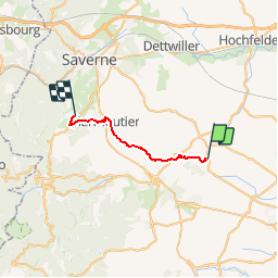
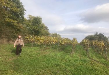
Tour Reiten von 18,4 km verfügbar auf Großer Osten, Unterelsass, Winzenheim. Diese Tour wird von Tourisme Equestre Alsace vorgeschlagen.
Beschreibung
Circuit SA Wintzenheim - Stambach
Ort
Land:
France
Region :
Großer Osten
Abteilung/Provinz :
Unterelsass
Kommune :
Winzenheim
Standort:
Unknown
Gehen Sie:(Dec)
Gehen Sie:(UTM)
390530 ; 5390574 (32U) N.
Kommentare
Touren in der Umgebung
![Tour Zu Fuß Kuttolsheim - Circuit des Trois Chapelles - Photo](https://media.geolcdn.com/t/375/260/3ceccad9-7dec-432b-9789-0d7c08657a66.jpeg&format=jpg&maxdim=2)
![Zu Fuß Zu Fuß](https://static1.geolcdn.com/sitytour/trail-icons/100.png)
Circuit des Trois Chapelles
Zu Fuß
Einfach
Kuttolsheim,
Großer Osten,
Unterelsass,
France
![](/images/other/stat-length.png)
9,6 km | 13,1 km-effort
2h 58min
![](https://static1.geolcdn.com/siteimages/upload/files/16400158638029165_repeat_loop_refresh_sync_direction_icon.png)
Nein
![Tour Wandern Nordheim - Nordheim 20240224 - Photo](https://media.geolcdn.com/t/375/260/6330086d-dc82-440a-bc76-484527f9dd0f.jpg&format=jpg&maxdim=2)
![Wandern Wandern](https://static1.geolcdn.com/sitytour/trail-icons/101.png)
Nordheim 20240224
Wandern
Schwierig
Nordheim,
Großer Osten,
Unterelsass,
France
![](/images/other/stat-length.png)
11,1 km | 15 km-effort
2h 53min
![](https://static1.geolcdn.com/siteimages/upload/files/16400158638029165_repeat_loop_refresh_sync_direction_icon.png)
Ja
![Tour Nordic Walking Nordheim - Nordheim 20220605 - Photo](https://media.geolcdn.com/t/375/260/aed5eb9f-a56f-46f2-8421-c2eed3cd4a7e.jpg&format=jpg&maxdim=2)
![Nordic Walking Nordic Walking](https://static1.geolcdn.com/sitytour/trail-icons/102.png)
Nordheim 20220605
Nordic Walking
Sehr leicht
Nordheim,
Großer Osten,
Unterelsass,
France
![](/images/other/stat-length.png)
26 km | 32 km-effort
3h 12min
![](https://static1.geolcdn.com/siteimages/upload/files/16400158638029165_repeat_loop_refresh_sync_direction_icon.png)
Nein
![Tour Wandern Wangen - , westhoffen - Photo](https://media.geolcdn.com/t/375/260/b175c1a5-0734-47ef-bc29-135efa0b24c4.jpg&format=jpg&maxdim=2)
![Wandern Wandern](https://static1.geolcdn.com/sitytour/trail-icons/101.png)
, westhoffen
Wandern
Medium
Wangen,
Großer Osten,
Unterelsass,
France
![](/images/other/stat-length.png)
9,9 km | 14,2 km-effort
2h 51min
![](https://static1.geolcdn.com/siteimages/upload/files/16400158638029165_repeat_loop_refresh_sync_direction_icon.png)
Ja
![Tour Wandern Wangen - track - Photo](https://media.geolcdn.com/t/375/260/ext.jpg?maxdim=2&url=https%3A%2F%2Fstatic1.geolcdn.com%2Fsiteimages%2Fupload%2Ffiles%2F1553511878bg_sport_marche.png)
![Wandern Wandern](https://static1.geolcdn.com/sitytour/trail-icons/101.png)
![Tour Wandern Marlenheim - Circuit de Bacchus - Le Riewerle - Photo](https://media.geolcdn.com/t/375/260/6511932e-c99b-4d78-a46a-48f9f567d62e.jpg&format=jpg&maxdim=2)
![Wandern Wandern](https://static1.geolcdn.com/sitytour/trail-icons/101.png)
Circuit de Bacchus - Le Riewerle
Wandern
Medium
Marlenheim,
Großer Osten,
Unterelsass,
France
![](/images/other/stat-length.png)
15,9 km | 19,7 km-effort
4h 44min
![](https://static1.geolcdn.com/siteimages/upload/files/16400158638029165_repeat_loop_refresh_sync_direction_icon.png)
Ja
![Tour Wandern Marlenheim - marlenheim - Photo](https://media.geolcdn.com/t/375/260/d21d2bcb-739a-4f47-8fde-2407d8985d2a.jpg&format=jpg&maxdim=2)
![Wandern Wandern](https://static1.geolcdn.com/sitytour/trail-icons/101.png)
marlenheim
Wandern
Medium
Marlenheim,
Großer Osten,
Unterelsass,
France
![](/images/other/stat-length.png)
11 km | 15,7 km-effort
3h 17min
![](https://static1.geolcdn.com/siteimages/upload/files/16400158638029165_repeat_loop_refresh_sync_direction_icon.png)
Ja
![Tour Wandern Nordheim - 2024-10-20-Balade Nordheim Marlenberg - Photo](https://media.geolcdn.com/t/375/260/bca68aed-8b3d-4dcb-af1b-0096f653faff.jpg&format=jpg&maxdim=2)
![Wandern Wandern](https://static1.geolcdn.com/sitytour/trail-icons/101.png)
2024-10-20-Balade Nordheim Marlenberg
Wandern
Medium
Nordheim,
Großer Osten,
Unterelsass,
France
![](/images/other/stat-length.png)
4,9 km | 6,7 km-effort
1h 31min
![](https://static1.geolcdn.com/siteimages/upload/files/16400158638029165_repeat_loop_refresh_sync_direction_icon.png)
Ja
![Tour Wandern Wasselnheim - Chez François - Photo](https://media.geolcdn.com/t/375/260/85c579c1-c5f9-42d9-9dab-f26e3fa05b29.jpg&format=jpg&maxdim=2)
![Wandern Wandern](https://static1.geolcdn.com/sitytour/trail-icons/101.png)
Chez François
Wandern
Medium
Wasselnheim,
Großer Osten,
Unterelsass,
France
![](/images/other/stat-length.png)
8,1 km | 11,2 km-effort
1h 41min
![](https://static1.geolcdn.com/siteimages/upload/files/16400158638029165_repeat_loop_refresh_sync_direction_icon.png)
Ja