![](/images/other/stat-length.png)
![Tour Andere Aktivitäten Wattwil - Wattwil - Neuhaus - Photo](https://media.geolcdn.com/t/1900/400/ext.pjpeg?maxdim=2&url=https%3A%2F%2Fstatic1.geolcdn.com%2Fsiteimages%2Fupload%2Ffiles%2F1545311037marcheuse_200dpi.jpg)
Wattwil - Neuhaus
hallauer
Benutzer
![Länge](/images/other/stat-length.png)
Länge
15,5 km
![Maximale Höhe](https://static1.geolcdn.com/siteimages/upload/files/1508320355ic_sort_altitude_max_24dp.png)
Maximale Höhe
988 m
![Positive Höhendifferenz](https://static1.geolcdn.com/siteimages/upload/files/1508320355ic_sort_den_pos_24dp.png)
Positive Höhendifferenz
502 m
![Km-Effort](/images/other/stat-length.png)
Km-Effort
23 km
![Min. Höhe](https://static1.geolcdn.com/siteimages/upload/files/1508320355ic_sort_altitude_min_24dp.png)
Min. Höhe
473 m
![Negative Höhendifferenz](https://static1.geolcdn.com/siteimages/upload/files/1508320355ic_sort_den_neg_24dp.png)
Negative Höhendifferenz
619 m
![Boucle](https://static1.geolcdn.com/siteimages/upload/files/16400158638029165_repeat_loop_refresh_sync_direction_icon.png)
Boucle
Nein
Erstellungsdatum :
2014-12-11 00:00:00.0
Letzte Änderung :
2014-12-11 00:00:00.0
![Andere Aktivitäten](https://static1.geolcdn.com/sitytour/trail-icons/900.png)
5h11
Schwierigkeit : Unbekannt
![Scannen Sie diesen QR-Code, um die Tour in der SityTrail-Anwendung zu öffnen](https://capi.geolives.com/qq0zvz2zws4bq2lad0pu/sitytour/trails/22327/qr.png?size=200)
Kostenlosegpshiking-Anwendung
Über SityTrail
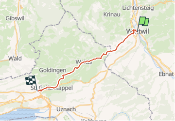
Tour Andere Aktivitäten von 15,5 km verfügbar auf Sankt Gallen, Wahlkreis Toggenburg, Wattwil. Diese Tour wird von hallauer vorgeschlagen.
Beschreibung
Der Pilgerweg führt zu Teilen über die "SwissMobil-Routen 44 und 4" Appenzellerweg und Via Jacobi
Ort
Land:
Switzerland
Region :
Sankt Gallen
Abteilung/Provinz :
Wahlkreis Toggenburg
Kommune :
Wattwil
Standort:
Unknown
Gehen Sie:(Dec)
Gehen Sie:(UTM)
506499 ; 5238384 (32T) N.
Kommentare
Touren in der Umgebung
![Tour Zu Fuß Neckertal - Brunnadern-Wilkehöchi - Photo](https://media.geolcdn.com/t/375/260/8cc06224-64f7-4e8c-83af-8cfc6d57b765.jpeg&format=jpg&maxdim=2)
![Zu Fuß Zu Fuß](https://static1.geolcdn.com/sitytour/trail-icons/100.png)
Brunnadern-Wilkehöchi
Zu Fuß
Einfach
Neckertal,
Sankt Gallen,
Wahlkreis Toggenburg,
Switzerland
![](/images/other/stat-length.png)
4,4 km | 9,9 km-effort
2h 15min
![](https://static1.geolcdn.com/siteimages/upload/files/16400158638029165_repeat_loop_refresh_sync_direction_icon.png)
Nein
![Tour Andere Aktivitäten Mosnang - y10_libingen - Photo](https://media.geolcdn.com/t/375/260/ext.jpg?maxdim=2&url=https%3A%2F%2Fstatic1.geolcdn.com%2Fsiteimages%2Fupload%2Ffiles%2F1545311037marcheuse_200dpi.jpg)
![Andere Aktivitäten Andere Aktivitäten](https://static1.geolcdn.com/sitytour/trail-icons/900.png)
y10_libingen
Andere Aktivitäten
Sehr leicht
Mosnang,
Sankt Gallen,
Wahlkreis Toggenburg,
Switzerland
![](/images/other/stat-length.png)
16,9 km | 30 km-effort
6h 42min
![](https://static1.geolcdn.com/siteimages/upload/files/16400158638029165_repeat_loop_refresh_sync_direction_icon.png)
Nein
![Tour Mountainbike Ebnat-Kappel - Ritteren - Photo](https://media.geolcdn.com/t/375/260/ext.jpg?maxdim=2&url=https%3A%2F%2Fstatic1.geolcdn.com%2Fsiteimages%2Fupload%2Ffiles%2F1524743154velo.jpg)
![Mountainbike Mountainbike](https://static1.geolcdn.com/sitytour/trail-icons/202.png)
Ritteren
Mountainbike
Sehr leicht
Ebnat-Kappel,
Sankt Gallen,
Wahlkreis Toggenburg,
Switzerland
![](/images/other/stat-length.png)
25 km | 35 km-effort
8h 58min
![](https://static1.geolcdn.com/siteimages/upload/files/16400158638029165_repeat_loop_refresh_sync_direction_icon.png)
Ja
![Tour Mountainbike Ebnat-Kappel - Bike32875 - Photo](https://media.geolcdn.com/t/375/260/ext.jpg?maxdim=2&url=https%3A%2F%2Fstatic1.geolcdn.com%2Fsiteimages%2Fupload%2Ffiles%2F1524743154velo.jpg)
![Mountainbike Mountainbike](https://static1.geolcdn.com/sitytour/trail-icons/202.png)
Bike32875
Mountainbike
Sehr leicht
Ebnat-Kappel,
Sankt Gallen,
Wahlkreis Toggenburg,
Switzerland
![](/images/other/stat-length.png)
20 km | 28 km-effort
Unbekannt
![](https://static1.geolcdn.com/siteimages/upload/files/16400158638029165_repeat_loop_refresh_sync_direction_icon.png)
Ja
![Tour Andere Aktivitäten Wattwil - Wattwil - Schmerikon - Photo](https://media.geolcdn.com/t/375/260/ext.jpg?maxdim=2&url=https%3A%2F%2Fstatic1.geolcdn.com%2Fsiteimages%2Fupload%2Ffiles%2F1545311037marcheuse_200dpi.jpg)
![Andere Aktivitäten Andere Aktivitäten](https://static1.geolcdn.com/sitytour/trail-icons/900.png)
Wattwil - Schmerikon
Andere Aktivitäten
Sehr leicht
Wattwil,
Sankt Gallen,
Wahlkreis Toggenburg,
Switzerland
![](/images/other/stat-length.png)
18,3 km | 26 km-effort
Unbekannt
![](https://static1.geolcdn.com/siteimages/upload/files/16400158638029165_repeat_loop_refresh_sync_direction_icon.png)
Nein
![Tour Andere Aktivitäten Eschenbach (SG) - JW Wattwil-Neuhaus Teil 2 - Photo](https://media.geolcdn.com/t/375/260/ext.jpg?maxdim=2&url=https%3A%2F%2Fstatic1.geolcdn.com%2Fsiteimages%2Fupload%2Ffiles%2F1545311037marcheuse_200dpi.jpg)
![Andere Aktivitäten Andere Aktivitäten](https://static1.geolcdn.com/sitytour/trail-icons/900.png)
JW Wattwil-Neuhaus Teil 2
Andere Aktivitäten
Sehr leicht
Eschenbach (SG),
Sankt Gallen,
Wahlkreis See-Gaster,
Switzerland
![](/images/other/stat-length.png)
7,9 km | 10,1 km-effort
Unbekannt
![](https://static1.geolcdn.com/siteimages/upload/files/16400158638029165_repeat_loop_refresh_sync_direction_icon.png)
Nein
![Tour Andere Aktivitäten Wattwil - JW Wattwil-Neuhaus Teil 1 - Photo](https://media.geolcdn.com/t/375/260/ext.jpg?maxdim=2&url=https%3A%2F%2Fstatic1.geolcdn.com%2Fsiteimages%2Fupload%2Ffiles%2F1545311037marcheuse_200dpi.jpg)
![Andere Aktivitäten Andere Aktivitäten](https://static1.geolcdn.com/sitytour/trail-icons/900.png)
JW Wattwil-Neuhaus Teil 1
Andere Aktivitäten
Sehr leicht
Wattwil,
Sankt Gallen,
Wahlkreis Toggenburg,
Switzerland
![](/images/other/stat-length.png)
4,5 km | 8,6 km-effort
Unbekannt
![](https://static1.geolcdn.com/siteimages/upload/files/16400158638029165_repeat_loop_refresh_sync_direction_icon.png)
Nein
![Tour Andere Aktivitäten Wattwil - Challenge 07/4 - Photo](https://media.geolcdn.com/t/375/260/ext.jpg?maxdim=2&url=https%3A%2F%2Fstatic1.geolcdn.com%2Fsiteimages%2Fupload%2Ffiles%2F1545311037marcheuse_200dpi.jpg)
![Andere Aktivitäten Andere Aktivitäten](https://static1.geolcdn.com/sitytour/trail-icons/900.png)
Challenge 07/4
Andere Aktivitäten
Sehr leicht
Wattwil,
Sankt Gallen,
Wahlkreis Toggenburg,
Switzerland
![](/images/other/stat-length.png)
19,2 km | 27 km-effort
Unbekannt
![](https://static1.geolcdn.com/siteimages/upload/files/16400158638029165_repeat_loop_refresh_sync_direction_icon.png)
Nein
![Tour Andere Aktivitäten Eschenbach (SG) - Chrüzegg - Photo](https://media.geolcdn.com/t/375/260/ext.jpg?maxdim=2&url=https%3A%2F%2Fstatic1.geolcdn.com%2Fsiteimages%2Fupload%2Ffiles%2F1545311037marcheuse_200dpi.jpg)
![Andere Aktivitäten Andere Aktivitäten](https://static1.geolcdn.com/sitytour/trail-icons/900.png)
Chrüzegg
Andere Aktivitäten
Sehr leicht
Eschenbach (SG),
Sankt Gallen,
Wahlkreis See-Gaster,
Switzerland
![](/images/other/stat-length.png)
5,8 km | 11,5 km-effort
Unbekannt
![](https://static1.geolcdn.com/siteimages/upload/files/16400158638029165_repeat_loop_refresh_sync_direction_icon.png)
Nein