![](/images/other/stat-length.png)
![Tour Zu Fuß Dinant - Bois d' Hulbise - Photo](https://media.geolcdn.com/t/1900/400/ext.pjpeg?maxdim=2&url=https%3A%2F%2Fstatic1.geolcdn.com%2Fsiteimages%2Fupload%2Ffiles%2F1545311037marcheuse_200dpi.jpg)
Bois d' Hulbise
ValleedelaMeuse
Benutzer
![Länge](/images/other/stat-length.png)
Länge
10,5 km
![Maximale Höhe](https://static1.geolcdn.com/siteimages/upload/files/1508320355ic_sort_altitude_max_24dp.png)
Maximale Höhe
272 m
![Positive Höhendifferenz](https://static1.geolcdn.com/siteimages/upload/files/1508320355ic_sort_den_pos_24dp.png)
Positive Höhendifferenz
149 m
![Km-Effort](/images/other/stat-length.png)
Km-Effort
12,4 km
![Min. Höhe](https://static1.geolcdn.com/siteimages/upload/files/1508320355ic_sort_altitude_min_24dp.png)
Min. Höhe
188 m
![Negative Höhendifferenz](https://static1.geolcdn.com/siteimages/upload/files/1508320355ic_sort_den_neg_24dp.png)
Negative Höhendifferenz
148 m
![Boucle](https://static1.geolcdn.com/siteimages/upload/files/16400158638029165_repeat_loop_refresh_sync_direction_icon.png)
Boucle
Ja
Erstellungsdatum :
2019-10-07 07:36:37.468
Letzte Änderung :
2019-10-07 07:42:36.463
![Zu Fuß](https://static1.geolcdn.com/sitytour/trail-icons/100.png)
3h00
Schwierigkeit : Einfach
![Scannen Sie diesen QR-Code, um die Tour in der SityTrail-Anwendung zu öffnen](https://capi.geolives.com/qq0zvz2zws4bq2lad0pu/sitytour/trails/2223862/qr.png?size=200)
Kostenlosegpshiking-Anwendung
Über SityTrail
Tour Zu Fuß von 10,5 km verfügbar auf Wallonien, Namur, Dinant. Diese Tour wird von ValleedelaMeuse vorgeschlagen.
Beschreibung
Départ de l' église de Falmagne vers le grand Cortil puis on alterne entre champs et bois jusqu'à Hulsonniaux. Retour par le bois d'Hulbise et le Ry de Vesse vers le village.
Ort
Land:
Belgium
Region :
Wallonien
Abteilung/Provinz :
Namur
Kommune :
Dinant
Standort:
Falmagne
Gehen Sie:(Dec)
Gehen Sie:(UTM)
635433 ; 5562583 (31U) N.
Kommentare
Touren in der Umgebung
![Wandern Wandern](https://static1.geolcdn.com/sitytour/trail-icons/101.png)
RB-Na-24-Entre Lesse et Meuse
Wandern
Sehr schwierig
(14)
Dinant,
Wallonien,
Namur,
Belgium
![](/images/other/stat-length.png)
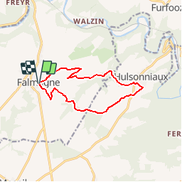
19,3 km | 26 km-effort
5h 57min
![](https://static1.geolcdn.com/siteimages/upload/files/16400158638029165_repeat_loop_refresh_sync_direction_icon.png)
Ja
![Tour Wandern Houyet - GG-NA-20_Gendron-Celles - Dinant - Photo](https://media.geolcdn.com/t/375/260/ab939ff5-5b33-43fd-b036-e462abc33a68.jpg&format=jpg&maxdim=2)
![Wandern Wandern](https://static1.geolcdn.com/sitytour/trail-icons/101.png)
GG-NA-20_Gendron-Celles - Dinant
Wandern
Sehr schwierig
(6)
Houyet,
Wallonien,
Namur,
Belgium
![](/images/other/stat-length.png)
23 km | 30 km-effort
6h 27min
![](https://static1.geolcdn.com/siteimages/upload/files/16400158638029165_repeat_loop_refresh_sync_direction_icon.png)
Nein
![Tour Wandern Dinant - D'Anseremme à Dinant - Photo](https://media.geolcdn.com/t/375/260/ext.jpg?maxdim=2&url=https%3A%2F%2Fservices.sitytrail.com%2FGeolivesWS%2FDownloadMedia.ashx%3FTrailID%3D375788%26Media%3D9ffb86bd-da6e-4936-82b7-07dbdf349394.JPG)
![Wandern Wandern](https://static1.geolcdn.com/sitytour/trail-icons/101.png)
D'Anseremme à Dinant
Wandern
Einfach
(3)
Dinant,
Wallonien,
Namur,
Belgium
![](/images/other/stat-length.png)
8,3 km | 11,8 km-effort
2h 34min
![](https://static1.geolcdn.com/siteimages/upload/files/16400158638029165_repeat_loop_refresh_sync_direction_icon.png)
Ja
![Wandern Wandern](https://static1.geolcdn.com/sitytour/trail-icons/101.png)
RB-Na-24-racc-Entre Lesse et Meuse
Wandern
Sehr schwierig
(4)
Dinant,
Wallonien,
Namur,
Belgium
![](/images/other/stat-length.png)
18,5 km | 24 km-effort
5h 29min
![](https://static1.geolcdn.com/siteimages/upload/files/16400158638029165_repeat_loop_refresh_sync_direction_icon.png)
Ja
![Tour Wandern Dinant - FURFFOZ ... les Aiguilles de Chaleux et la Réserve naturelle. - Photo](https://media.geolcdn.com/t/375/260/5397ac9f-a7ea-4ef6-be10-3fc6907b1e23.jpg&format=jpg&maxdim=2)
![Wandern Wandern](https://static1.geolcdn.com/sitytour/trail-icons/101.png)
FURFFOZ ... les Aiguilles de Chaleux et la Réserve naturelle.
Wandern
Einfach
(6)
Dinant,
Wallonien,
Namur,
Belgium
![](/images/other/stat-length.png)
9,6 km | 12,9 km-effort
1h 38min
![](https://static1.geolcdn.com/siteimages/upload/files/16400158638029165_repeat_loop_refresh_sync_direction_icon.png)
Ja
![Tour Wandern Dinant - ANSEREMME (Passerelle) - Photo](https://media.geolcdn.com/t/375/260/ext.jpg?maxdim=2&url=https%3A%2F%2Fservices.sitytrail.com%2FGeolivesWS%2FDownloadMedia.ashx%3FTrailID%3D525086%26Media%3Dfix__20160213155638.jpg)
![Wandern Wandern](https://static1.geolcdn.com/sitytour/trail-icons/101.png)
ANSEREMME (Passerelle)
Wandern
Einfach
(4)
Dinant,
Wallonien,
Namur,
Belgium
![](/images/other/stat-length.png)
11,6 km | 15 km-effort
3h 15min
![](https://static1.geolcdn.com/siteimages/upload/files/16400158638029165_repeat_loop_refresh_sync_direction_icon.png)
Ja
![Tour Wandern Hastière - Waulsort - Circuit Natura 2000, des sites qui valent le détour - Na08 - Photo](https://media.geolcdn.com/t/375/260/ext.jpg?maxdim=2&url=https%3A%2F%2Fservices.sitytrail.com%2FGeolivesWS%2FDownloadMedia.ashx%3FTrailID%3D434736%26Media%3D6da8fd5b-7dc9-4341-8780-4fc280ddf4d9.JPG)
![Wandern Wandern](https://static1.geolcdn.com/sitytour/trail-icons/101.png)
Waulsort - Circuit Natura 2000, des sites qui valent le détour - Na08
Wandern
Sehr leicht
(4)
Hastière,
Wallonien,
Namur,
Belgium
![](/images/other/stat-length.png)
4,5 km | 6,9 km-effort
1h 40min
![](https://static1.geolcdn.com/siteimages/upload/files/16400158638029165_repeat_loop_refresh_sync_direction_icon.png)
Ja
![Tour Wandern Houyet - la lesse de bas en haut - Photo](https://media.geolcdn.com/t/375/260/ext.jpg?maxdim=2&url=https%3A%2F%2Fservices.sitytrail.com%2FGeolivesWS%2FDownloadMedia.ashx%3FTrailID%3D315226%26Media%3Dfix__20140622124242.jpg)
![Wandern Wandern](https://static1.geolcdn.com/sitytour/trail-icons/101.png)
la lesse de bas en haut
Wandern
Medium
(3)
Houyet,
Wallonien,
Namur,
Belgium
![](/images/other/stat-length.png)
6,8 km | 9,1 km-effort
1h 21min
![](https://static1.geolcdn.com/siteimages/upload/files/16400158638029165_repeat_loop_refresh_sync_direction_icon.png)
Ja
![Tour Wandern Hastière - Balade à Waulsort - Photo](https://media.geolcdn.com/t/375/260/430266b1-8cd2-4495-b460-1dbc4ae413f0.jpg&format=jpg&maxdim=2)
![Wandern Wandern](https://static1.geolcdn.com/sitytour/trail-icons/101.png)
Balade à Waulsort
Wandern
Medium
Hastière,
Wallonien,
Namur,
Belgium
![](/images/other/stat-length.png)
6,5 km | 8,6 km-effort
1h 56min
![](https://static1.geolcdn.com/siteimages/upload/files/16400158638029165_repeat_loop_refresh_sync_direction_icon.png)
Ja