![](/images/other/stat-length.png)
![Tour Elektrofahrrad Saint-Laurent-du-Pape - Via douce St Vincent de Durfort St Cierge - Photo](https://media.geolcdn.com/t/1900/400/ext.pjpeg?maxdim=2&url=https%3A%2F%2Fstatic1.geolcdn.com%2Fsiteimages%2Fupload%2Ffiles%2F1524743154velo.jpg)
Via douce St Vincent de Durfort St Cierge
chevallier
Benutzer
![Länge](/images/other/stat-length.png)
Länge
36 km
![Maximale Höhe](https://static1.geolcdn.com/siteimages/upload/files/1508320355ic_sort_altitude_max_24dp.png)
Maximale Höhe
562 m
![Positive Höhendifferenz](https://static1.geolcdn.com/siteimages/upload/files/1508320355ic_sort_den_pos_24dp.png)
Positive Höhendifferenz
868 m
![Km-Effort](/images/other/stat-length.png)
Km-Effort
48 km
![Min. Höhe](https://static1.geolcdn.com/siteimages/upload/files/1508320355ic_sort_altitude_min_24dp.png)
Min. Höhe
115 m
![Negative Höhendifferenz](https://static1.geolcdn.com/siteimages/upload/files/1508320355ic_sort_den_neg_24dp.png)
Negative Höhendifferenz
868 m
![Boucle](https://static1.geolcdn.com/siteimages/upload/files/16400158638029165_repeat_loop_refresh_sync_direction_icon.png)
Boucle
Ja
Erstellungsdatum :
2019-09-26 12:42:19.001
Letzte Änderung :
2019-10-08 11:11:13.753
![Elektrofahrrad](https://static1.geolcdn.com/sitytour/trail-icons/205.png)
--
Schwierigkeit : Sehr leicht
![Scannen Sie diesen QR-Code, um die Tour in der SityTrail-Anwendung zu öffnen](https://capi.geolives.com/qq0zvz2zws4bq2lad0pu/sitytour/trails/2214432/qr.png?size=200)
Kostenlosegpshiking-Anwendung
Über SityTrail
Tour Elektrofahrrad von 36 km verfügbar auf Auvergne-Rhone-Alpen, Ardèche, Saint-Laurent-du-Pape. Diese Tour wird von chevallier vorgeschlagen.
Beschreibung
Circuit via douce La Voulte Les Ollières retoutretour par St Cierge avec évitement de la départementale entre les Ollières et Privas ainsi que de la traversée du La Voulte.
Ort
Land:
France
Region :
Auvergne-Rhone-Alpen
Abteilung/Provinz :
Ardèche
Kommune :
Saint-Laurent-du-Pape
Standort:
Unknown
Gehen Sie:(Dec)
Gehen Sie:(UTM)
640195 ; 4964669 (31T) N.
Kommentare
Touren in der Umgebung
![Tour Wandern Saint-Laurent-du-Pape - 07 st Laurent du pape P Gourde 060521 - Photo](https://media.geolcdn.com/t/375/260/ab7e67df-3108-4810-a988-7cdece498721.jpg&format=jpg&maxdim=2)
![Wandern Wandern](https://static1.geolcdn.com/sitytour/trail-icons/101.png)
07 st Laurent du pape P Gourde 060521
Wandern
Einfach
(1)
Saint-Laurent-du-Pape,
Auvergne-Rhone-Alpen,
Ardèche,
France
![](/images/other/stat-length.png)
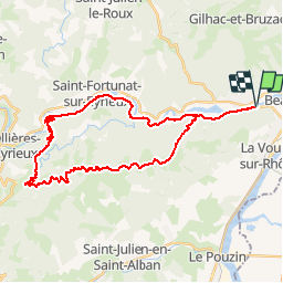
13,9 km | 22 km-effort
5h 56min
![](https://static1.geolcdn.com/siteimages/upload/files/16400158638029165_repeat_loop_refresh_sync_direction_icon.png)
Ja
![Tour Wandern La Voulte-sur-Rhône - La Voulte Via-Rhôna 7KM - Photo](https://media.geolcdn.com/t/375/260/620eea2b-7c65-44be-a1eb-b1fcfc74c039.jpg&format=jpg&maxdim=2)
![Wandern Wandern](https://static1.geolcdn.com/sitytour/trail-icons/101.png)
La Voulte Via-Rhôna 7KM
Wandern
Medium
(1)
La Voulte-sur-Rhône,
Auvergne-Rhone-Alpen,
Ardèche,
France
![](/images/other/stat-length.png)
6,6 km | 7,5 km-effort
1h 42min
![](https://static1.geolcdn.com/siteimages/upload/files/16400158638029165_repeat_loop_refresh_sync_direction_icon.png)
Ja
![Tour Wandern Beauchastel - Beauchastel. / Pierre Gourde - Photo](https://media.geolcdn.com/t/375/260/ext.jpg?maxdim=2&url=https%3A%2F%2Fservices.sitytrail.com%2FGeolivesWS%2FDownloadMedia.ashx%3FTrailID%3D500378%26Media%3Dfix__20151206162513.jpg)
![Wandern Wandern](https://static1.geolcdn.com/sitytour/trail-icons/101.png)
Beauchastel. / Pierre Gourde
Wandern
Medium
(3)
Beauchastel,
Auvergne-Rhone-Alpen,
Ardèche,
France
![](/images/other/stat-length.png)
21 km | 30 km-effort
6h 40min
![](https://static1.geolcdn.com/siteimages/upload/files/16400158638029165_repeat_loop_refresh_sync_direction_icon.png)
Ja
![Tour Rennrad La Voulte-sur-Rhône - 07 la voulte privas voie payre - Photo](https://media.geolcdn.com/t/375/260/a0a6e94a-154b-402d-a870-cb27302170ee.jpg&format=jpg&maxdim=2)
![Rennrad Rennrad](https://static1.geolcdn.com/sitytour/trail-icons/201.png)
07 la voulte privas voie payre
Rennrad
Medium
La Voulte-sur-Rhône,
Auvergne-Rhone-Alpen,
Ardèche,
France
![](/images/other/stat-length.png)
67 km | 83 km-effort
5h 21min
![](https://static1.geolcdn.com/siteimages/upload/files/16400158638029165_repeat_loop_refresh_sync_direction_icon.png)
Ja
![Tour Wandern La Voulte-sur-Rhône - La Voulte ViaRhona 6,5km - Photo](https://media.geolcdn.com/t/375/260/9614651f-4007-44ca-9c3c-97a6e4ce7270.jpg&format=jpg&maxdim=2)
![Wandern Wandern](https://static1.geolcdn.com/sitytour/trail-icons/101.png)
La Voulte ViaRhona 6,5km
Wandern
Einfach
La Voulte-sur-Rhône,
Auvergne-Rhone-Alpen,
Ardèche,
France
![](/images/other/stat-length.png)
6,5 km | 7,5 km-effort
2h 0min
![](https://static1.geolcdn.com/siteimages/upload/files/16400158638029165_repeat_loop_refresh_sync_direction_icon.png)
Ja
![Tour Wandern Saint-Laurent-du-Pape - Pierre gourde TeD Christian - Photo](https://media.geolcdn.com/t/375/260/ext.jpg?maxdim=2&url=https%3A%2F%2Fstatic1.geolcdn.com%2Fsiteimages%2Fupload%2Ffiles%2F1553511878bg_sport_marche.png)
![Wandern Wandern](https://static1.geolcdn.com/sitytour/trail-icons/101.png)
Pierre gourde TeD Christian
Wandern
Einfach
(1)
Saint-Laurent-du-Pape,
Auvergne-Rhone-Alpen,
Ardèche,
France
![](/images/other/stat-length.png)
8,6 km | 13,7 km-effort
3h 1min
![](https://static1.geolcdn.com/siteimages/upload/files/16400158638029165_repeat_loop_refresh_sync_direction_icon.png)
Ja
![Tour Wandern Saint-Georges-les-Bains - Saint Georges les Bains - Photo](https://media.geolcdn.com/t/375/260/e93486d4-d5f4-4b3e-8536-d4298013ea4d.jpg&format=jpg&maxdim=2)
![Wandern Wandern](https://static1.geolcdn.com/sitytour/trail-icons/101.png)
Saint Georges les Bains
Wandern
Sehr schwierig
Saint-Georges-les-Bains,
Auvergne-Rhone-Alpen,
Ardèche,
France
![](/images/other/stat-length.png)
16,4 km | 23 km-effort
5h 19min
![](https://static1.geolcdn.com/siteimages/upload/files/16400158638029165_repeat_loop_refresh_sync_direction_icon.png)
Ja
![Tour Wandern Saint-Georges-les-Bains - col de Rotison - Photo](https://media.geolcdn.com/t/375/260/8c3d1009-c72f-4ec6-bf61-7a2fde476dc2.jpg&format=jpg&maxdim=2)
![Wandern Wandern](https://static1.geolcdn.com/sitytour/trail-icons/101.png)
col de Rotison
Wandern
Schwierig
Saint-Georges-les-Bains,
Auvergne-Rhone-Alpen,
Ardèche,
France
![](/images/other/stat-length.png)
9,4 km | 14,4 km-effort
6h 7min
![](https://static1.geolcdn.com/siteimages/upload/files/16400158638029165_repeat_loop_refresh_sync_direction_icon.png)
Ja
![Tour Wandern Saint-Laurent-du-Pape - 07 st Laurent du pape zel - Photo](https://media.geolcdn.com/t/375/260/e32d23cf-7d2c-48ae-91cd-162887108580.jpg&format=jpg&maxdim=2)
![Wandern Wandern](https://static1.geolcdn.com/sitytour/trail-icons/101.png)
07 st Laurent du pape zel
Wandern
Medium
Saint-Laurent-du-Pape,
Auvergne-Rhone-Alpen,
Ardèche,
France
![](/images/other/stat-length.png)
14,5 km | 24 km-effort
6h 11min
![](https://static1.geolcdn.com/siteimages/upload/files/16400158638029165_repeat_loop_refresh_sync_direction_icon.png)
Ja