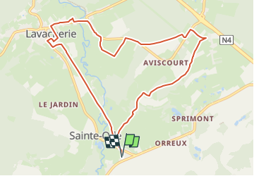
![](/images/other/stat-length.png)
![Tour Nordic Walking Sainte-Ode - Marche nordique NW3 - Le Tour d'Orti - Photo](https://media.geolcdn.com/t/1900/400/ext.pjpeg?maxdim=2&url=https%3A%2F%2Fstatic1.geolcdn.com%2Fsiteimages%2Fupload%2Ffiles%2F1545311037marcheuse_200dpi.jpg)
Marche nordique NW3 - Le Tour d'Orti
denissculier
Benutzer
![Länge](/images/other/stat-length.png)
![Maximale Höhe](https://static1.geolcdn.com/siteimages/upload/files/1508320355ic_sort_altitude_max_24dp.png)
![Positive Höhendifferenz](https://static1.geolcdn.com/siteimages/upload/files/1508320355ic_sort_den_pos_24dp.png)
![Km-Effort](/images/other/stat-length.png)
![Min. Höhe](https://static1.geolcdn.com/siteimages/upload/files/1508320355ic_sort_altitude_min_24dp.png)
![Negative Höhendifferenz](https://static1.geolcdn.com/siteimages/upload/files/1508320355ic_sort_den_neg_24dp.png)
![Boucle](https://static1.geolcdn.com/siteimages/upload/files/16400158638029165_repeat_loop_refresh_sync_direction_icon.png)
![Nordic Walking](https://static1.geolcdn.com/sitytour/trail-icons/102.png)
2h22
Schwierigkeit : Medium
![Scannen Sie diesen QR-Code, um die Tour in der SityTrail-Anwendung zu öffnen](https://capi.geolives.com/qq0zvz2zws4bq2lad0pu/sitytour/trails/2212257/qr.png?size=200)
Kostenlosegpshiking-Anwendung
Über SityTrail
Tour Nordic Walking von 9,5 km verfügbar auf Wallonien, Luxemburg, Sainte-Ode. Diese Tour wird von denissculier vorgeschlagen.
Beschreibung
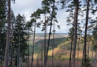
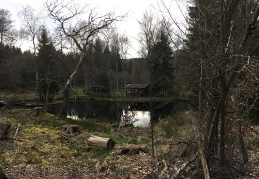
Cet itinéraire de marche nordique, essentiellement en milieu rural et agricole, part du village d'Amberloup en direction de la réserve naturelle d'Orti. Il offre une très belle vue sur la Vallée.Traversant les villages de Aviscourt et de Lavacherie, il passe également sur l'ancienne voie du Vicinal. S'il offre de beaux paysages notamment en cas de neige, il est déconseillé en plein été car il est peu ombragé. Cet itinéraire fait partie de l'Ardenne Nordic Park (www.ardenne-nordic-park.be).
Ort
Kommentare
Touren in der Umgebung
![Tour Wandern Sainte-Ode - RB-LUX-08 - Raccourci - De part et d’autre de l’Ourthe occidentale - Photo](https://media.geolcdn.com/t/375/260/ext.jpg?maxdim=2&url=https%3A%2F%2Fservices.sitytrail.com%2FGeolivesWS%2FDownloadMedia.ashx%3FTrailID%3D216067%26Media%3Da5159bed-d44e-45f6-91bf-98d2633ab672.jpg)
![Wandern Wandern](https://static1.geolcdn.com/sitytour/trail-icons/101.png)
Wandern
![](/images/other/stat-length.png)
![](https://static1.geolcdn.com/siteimages/upload/files/16400158638029165_repeat_loop_refresh_sync_direction_icon.png)
![Tour Wandern Sainte-Ode - Wandeling van Tonny - Photo](https://media.geolcdn.com/t/375/260/ext.jpg?maxdim=2&url=https%3A%2F%2Fservices.sitytrail.com%2FGeolivesWS%2FDownloadMedia.ashx%3FTrailID%3D470390%26Media%3D36d9826a-10d7-493f-bb50-7affdbc9817f.jpg)
![Wandern Wandern](https://static1.geolcdn.com/sitytour/trail-icons/101.png)
Wandern
![](/images/other/stat-length.png)
![](https://static1.geolcdn.com/siteimages/upload/files/16400158638029165_repeat_loop_refresh_sync_direction_icon.png)
![Tour Wandern Sainte-Ode - Beauplateau - Wandeling](https://media.geolcdn.com/t/375/260/ext.jpg?maxdim=2&url=https%3A%2F%2Fservices.sitytrail.com%2FGeolivesWS%2FDownloadMedia.ashx%3FTrailID%3D334523%26Media%3D18a8c2b6-d141-493c-b9d2-49dc585d80d8.JPG)
![Wandern Wandern](https://static1.geolcdn.com/sitytour/trail-icons/101.png)
Wandern
![](/images/other/stat-length.png)
![](https://static1.geolcdn.com/siteimages/upload/files/16400158638029165_repeat_loop_refresh_sync_direction_icon.png)
![Tour Wandern Sainte-Ode - Sainte-Ode - Wandeling van de Bonne Dame - Photo](https://media.geolcdn.com/t/375/260/ext.jpg?maxdim=2&url=https%3A%2F%2Fservices.sitytrail.com%2FGeolivesWS%2FDownloadMedia.ashx%3FTrailID%3D334508%26Media%3Dbeafdf5d-7e56-47ba-baef-9d2f39d35ed9.png)
![Wandern Wandern](https://static1.geolcdn.com/sitytour/trail-icons/101.png)
Wandern
![](/images/other/stat-length.png)
![](https://static1.geolcdn.com/siteimages/upload/files/16400158638029165_repeat_loop_refresh_sync_direction_icon.png)
![Tour Wandern Sainte-Ode - Amberloup, Natura 2000 - Des sites qui valent le détour. Lx11 - Photo](https://media.geolcdn.com/t/375/260/ext.jpg?maxdim=2&url=https%3A%2F%2Fservices.sitytrail.com%2FGeolivesWS%2FDownloadMedia.ashx%3FTrailID%3D181909%26Media%3Dd96a433d-6654-4704-ae71-038ac1db039e.JPG)
![Wandern Wandern](https://static1.geolcdn.com/sitytour/trail-icons/101.png)
Wandern
![](/images/other/stat-length.png)
![](https://static1.geolcdn.com/siteimages/upload/files/16400158638029165_repeat_loop_refresh_sync_direction_icon.png)
![Tour Wandern Sainte-Ode - RB-LUX-08 - De part et d’autre de l’Ourthe occidentale - Photo](https://media.geolcdn.com/t/375/260/ext.jpg?maxdim=2&url=https%3A%2F%2Fservices.sitytrail.com%2FGeolivesWS%2FDownloadMedia.ashx%3FTrailID%3D179624%26Media%3D32148395-8c8d-48d3-9d07-5af495614365.jpg)
![Wandern Wandern](https://static1.geolcdn.com/sitytour/trail-icons/101.png)
Wandern
![](/images/other/stat-length.png)
![](https://static1.geolcdn.com/siteimages/upload/files/16400158638029165_repeat_loop_refresh_sync_direction_icon.png)
![Tour Wandern Sainte-Ode - rando lavacherie 5-02-2022 - Photo](https://media.geolcdn.com/t/375/260/51d83bb4-0870-46ee-b60b-b2146d049ac2.jpg&format=jpg&maxdim=2)
![Wandern Wandern](https://static1.geolcdn.com/sitytour/trail-icons/101.png)
Wandern
![](/images/other/stat-length.png)
![](https://static1.geolcdn.com/siteimages/upload/files/16400158638029165_repeat_loop_refresh_sync_direction_icon.png)
![Tour Wandern Sainte-Ode - rando lavacherie 29/08/2020 - Photo](https://media.geolcdn.com/t/375/260/748c1b0e-fc3a-4c4c-86ea-3c557994f8d1.jpg&format=jpg&maxdim=2)
![Wandern Wandern](https://static1.geolcdn.com/sitytour/trail-icons/101.png)
Wandern
![](/images/other/stat-length.png)
![](https://static1.geolcdn.com/siteimages/upload/files/16400158638029165_repeat_loop_refresh_sync_direction_icon.png)
![Tour Zu Fuß Sainte-Ode - Sainte-ode - Photo](https://media.geolcdn.com/t/375/260/176a04b2-22ff-4a89-b268-e407ad0ae248.jpg&format=jpg&maxdim=2)
![Zu Fuß Zu Fuß](https://static1.geolcdn.com/sitytour/trail-icons/100.png)
Zu Fuß
![](/images/other/stat-length.png)
![](https://static1.geolcdn.com/siteimages/upload/files/16400158638029165_repeat_loop_refresh_sync_direction_icon.png)