![](/images/other/stat-length.png)
![Tour Zu Fuß Grisy-Suisnes - Grisy-Suisnes, chemin des roses,petit château, écomusée - Photo](https://media.geolcdn.com/t/1900/400/ext.pjpeg?maxdim=2&url=https%3A%2F%2Fstatic1.geolcdn.com%2Fsiteimages%2Fupload%2Ffiles%2F1545311037marcheuse_200dpi.jpg)
Grisy-Suisnes, chemin des roses,petit château, écomusée
Surot
Benutzer
![Länge](/images/other/stat-length.png)
Länge
7,7 km
![Maximale Höhe](https://static1.geolcdn.com/siteimages/upload/files/1508320355ic_sort_altitude_max_24dp.png)
Maximale Höhe
101 m
![Positive Höhendifferenz](https://static1.geolcdn.com/siteimages/upload/files/1508320355ic_sort_den_pos_24dp.png)
Positive Höhendifferenz
60 m
![Km-Effort](/images/other/stat-length.png)
Km-Effort
8,5 km
![Min. Höhe](https://static1.geolcdn.com/siteimages/upload/files/1508320355ic_sort_altitude_min_24dp.png)
Min. Höhe
70 m
![Negative Höhendifferenz](https://static1.geolcdn.com/siteimages/upload/files/1508320355ic_sort_den_neg_24dp.png)
Negative Höhendifferenz
60 m
![Boucle](https://static1.geolcdn.com/siteimages/upload/files/16400158638029165_repeat_loop_refresh_sync_direction_icon.png)
Boucle
Ja
Erstellungsdatum :
2019-09-20 08:54:00.013
Letzte Änderung :
2019-09-20 09:00:02.634
![Zu Fuß](https://static1.geolcdn.com/sitytour/trail-icons/100.png)
2h10
Schwierigkeit : Einfach
![Scannen Sie diesen QR-Code, um die Tour in der SityTrail-Anwendung zu öffnen](https://capi.geolives.com/qq0zvz2zws4bq2lad0pu/sitytour/trails/2209227/qr.png?size=200)
Kostenlosegpshiking-Anwendung
Über SityTrail
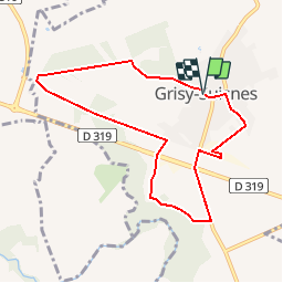
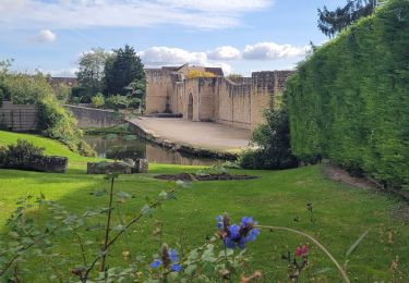
Tour Zu Fuß von 7,7 km verfügbar auf Île-de-France, Seine-et-Marne, Grisy-Suisnes. Diese Tour wird von Surot vorgeschlagen.
Beschreibung
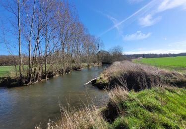
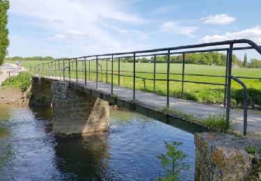
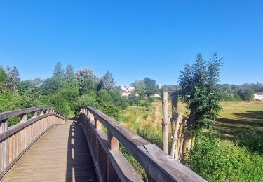
Petite boucle de rando douce ou santé en terrain quasi plat dans la bourgade de Grisy- Suisnes , en lisière bois-champ puis chemein des roses, l'écomusée mais qui n'est ouvert que le dimanche AM, et dans la ville vers son beffroi.
Ort
Land:
France
Region :
Île-de-France
Abteilung/Provinz :
Seine-et-Marne
Kommune :
Grisy-Suisnes
Standort:
Unknown
Gehen Sie:(Dec)
Gehen Sie:(UTM)
475343 ; 5392498 (31U) N.
Kommentare
Touren in der Umgebung
![Tour Wandern Brie-Comte-Robert - brie comte robert - Photo](https://media.geolcdn.com/t/375/260/ext.jpg?maxdim=2&url=https%3A%2F%2Fservices.sitytrail.com%2FGeolivesWS%2FDownloadMedia.ashx%3FTrailID%3D172162%26Media%3D20130130123759.jpeg)
![Wandern Wandern](https://static1.geolcdn.com/sitytour/trail-icons/101.png)
brie comte robert
Wandern
Einfach
(2)
Brie-Comte-Robert,
Île-de-France,
Seine-et-Marne,
France
![](/images/other/stat-length.png)
16,7 km | 18,8 km-effort
4h 21min
![](https://static1.geolcdn.com/siteimages/upload/files/16400158638029165_repeat_loop_refresh_sync_direction_icon.png)
Ja
![Tour Wandern Évry-Grégy-sur-Yerre - J 55 miguelmillepattes Evry Grégy sur Yerres - Prieuré de Vernelle - Photo](https://media.geolcdn.com/t/375/260/ext.jpg?maxdim=2&url=https%3A%2F%2Fmedia.geolcdn.com%2Ff%2F838bff98-2775-4bd0-83b3-89163c602221.jpg)
![Wandern Wandern](https://static1.geolcdn.com/sitytour/trail-icons/101.png)
J 55 miguelmillepattes Evry Grégy sur Yerres - Prieuré de Vernelle
Wandern
Medium
(2)
Évry-Grégy-sur-Yerre,
Île-de-France,
Seine-et-Marne,
France
![](/images/other/stat-length.png)
11,9 km | 13,6 km-effort
3h 5min
![](https://static1.geolcdn.com/siteimages/upload/files/16400158638029165_repeat_loop_refresh_sync_direction_icon.png)
Ja
![Tour Wandern Coubert - JC 27 Coubert, Solers cimetière allemand, Prieuré de Vernelle - Photo](https://media.geolcdn.com/t/375/260/ext.jpg?maxdim=2&url=https%3A%2F%2Fmedia.geolcdn.com%2Ff%2Fb6b52968-ca6b-4031-862f-615df2d504ec.jpg)
![Wandern Wandern](https://static1.geolcdn.com/sitytour/trail-icons/101.png)
JC 27 Coubert, Solers cimetière allemand, Prieuré de Vernelle
Wandern
Schwierig
(1)
Coubert,
Île-de-France,
Seine-et-Marne,
France
![](/images/other/stat-length.png)
20 km | 23 km-effort
5h 11min
![](https://static1.geolcdn.com/siteimages/upload/files/16400158638029165_repeat_loop_refresh_sync_direction_icon.png)
Ja
![Tour Zu Fuß Soignolles-en-Brie - L 22 5km gués de Barneau - Photo](https://media.geolcdn.com/t/375/260/ext.jpg?maxdim=2&url=https%3A%2F%2Fmedia.geolcdn.com%2Ff%2Fcef3660d-bb64-4c7a-911e-b5ee4181c187.jpg)
![Zu Fuß Zu Fuß](https://static1.geolcdn.com/sitytour/trail-icons/100.png)
L 22 5km gués de Barneau
Zu Fuß
Sehr leicht
(2)
Soignolles-en-Brie,
Île-de-France,
Seine-et-Marne,
France
![](/images/other/stat-length.png)
5,1 km | 5,9 km-effort
Unbekannt
![](https://static1.geolcdn.com/siteimages/upload/files/16400158638029165_repeat_loop_refresh_sync_direction_icon.png)
Ja
![Tour Wandern Brie-Comte-Robert - AdxBCR12,3PlaineChvry - Photo](https://media.geolcdn.com/t/375/260/ext.jpg?maxdim=2&url=https%3A%2F%2Fstatic1.geolcdn.com%2Fsiteimages%2Fupload%2Ffiles%2F1553511878bg_sport_marche.png)
![Wandern Wandern](https://static1.geolcdn.com/sitytour/trail-icons/101.png)
AdxBCR12,3PlaineChvry
Wandern
Schwierig
(1)
Brie-Comte-Robert,
Île-de-France,
Seine-et-Marne,
France
![](/images/other/stat-length.png)
13,4 km | 14,1 km-effort
3h 11min
![](https://static1.geolcdn.com/siteimages/upload/files/16400158638029165_repeat_loop_refresh_sync_direction_icon.png)
Ja
![Tour Wandern Brie-Comte-Robert - AdxBCR25MandreMarolles - Photo](https://media.geolcdn.com/t/375/260/ext.jpg?maxdim=2&url=https%3A%2F%2Fstatic1.geolcdn.com%2Fsiteimages%2Fupload%2Ffiles%2F1553511878bg_sport_marche.png)
![Wandern Wandern](https://static1.geolcdn.com/sitytour/trail-icons/101.png)
AdxBCR25MandreMarolles
Wandern
Schwierig
(1)
Brie-Comte-Robert,
Île-de-France,
Seine-et-Marne,
France
![](/images/other/stat-length.png)
13,6 km | 14,9 km-effort
3h 23min
![](https://static1.geolcdn.com/siteimages/upload/files/16400158638029165_repeat_loop_refresh_sync_direction_icon.png)
Ja
![Tour Zu Fuß Évry-Grégy-sur-Yerre - TRACES_VISIBLES - Photo](https://media.geolcdn.com/t/375/260/ext.jpg?maxdim=2&url=https%3A%2F%2Fstatic1.geolcdn.com%2Fsiteimages%2Fupload%2Ffiles%2F1545311037marcheuse_200dpi.jpg)
![Zu Fuß Zu Fuß](https://static1.geolcdn.com/sitytour/trail-icons/100.png)
TRACES_VISIBLES
Zu Fuß
Einfach
(1)
Évry-Grégy-sur-Yerre,
Île-de-France,
Seine-et-Marne,
France
![](/images/other/stat-length.png)
10,8 km | 12,6 km-effort
2h 51min
![](https://static1.geolcdn.com/siteimages/upload/files/16400158638029165_repeat_loop_refresh_sync_direction_icon.png)
Ja
![Tour Zu Fuß Brie-Comte-Robert - JC 22 Brie, grisy,suisnes,evry les chateaux, grégy - Photo](https://media.geolcdn.com/t/375/260/ext.jpg?maxdim=2&url=https%3A%2F%2Fstatic1.geolcdn.com%2Fsiteimages%2Fupload%2Ffiles%2F1545311037marcheuse_200dpi.jpg)
![Zu Fuß Zu Fuß](https://static1.geolcdn.com/sitytour/trail-icons/100.png)
JC 22 Brie, grisy,suisnes,evry les chateaux, grégy
Zu Fuß
Schwierig
(1)
Brie-Comte-Robert,
Île-de-France,
Seine-et-Marne,
France
![](/images/other/stat-length.png)
21 km | 24 km-effort
5h 0min
![](https://static1.geolcdn.com/siteimages/upload/files/16400158638029165_repeat_loop_refresh_sync_direction_icon.png)
Ja
![Tour Mountainbike Brie-Comte-Robert - Chemin des Roses et Vallée De l'Yerre - Photo](https://media.geolcdn.com/t/375/260/ext.jpg?maxdim=2&url=https%3A%2F%2Fstatic1.geolcdn.com%2Fsiteimages%2Fupload%2Ffiles%2F1524743154velo.jpg)
![Mountainbike Mountainbike](https://static1.geolcdn.com/sitytour/trail-icons/202.png)
Chemin des Roses et Vallée De l'Yerre
Mountainbike
Medium
(2)
Brie-Comte-Robert,
Île-de-France,
Seine-et-Marne,
France
![](/images/other/stat-length.png)
39 km | 43 km-effort
2h 50min
![](https://static1.geolcdn.com/siteimages/upload/files/16400158638029165_repeat_loop_refresh_sync_direction_icon.png)
Ja