![](/images/other/stat-length.png)
![Tour Wandern Gundis - Mayens de Conthey - Croix de la châ - Photo](https://media.geolcdn.com/t/1900/400/ext.pjpeg?maxdim=2&url=https%3A%2F%2Fstatic1.geolcdn.com%2Fsiteimages%2Fupload%2Ffiles%2F1553511878bg_sport_marche.png)
Mayens de Conthey - Croix de la châ
duamerg
Benutzer
![Länge](/images/other/stat-length.png)
Länge
15,1 km
![Maximale Höhe](https://static1.geolcdn.com/siteimages/upload/files/1508320355ic_sort_altitude_max_24dp.png)
Maximale Höhe
2350 m
![Positive Höhendifferenz](https://static1.geolcdn.com/siteimages/upload/files/1508320355ic_sort_den_pos_24dp.png)
Positive Höhendifferenz
941 m
![Km-Effort](/images/other/stat-length.png)
Km-Effort
28 km
![Min. Höhe](https://static1.geolcdn.com/siteimages/upload/files/1508320355ic_sort_altitude_min_24dp.png)
Min. Höhe
1477 m
![Negative Höhendifferenz](https://static1.geolcdn.com/siteimages/upload/files/1508320355ic_sort_den_neg_24dp.png)
Negative Höhendifferenz
948 m
![Boucle](https://static1.geolcdn.com/siteimages/upload/files/16400158638029165_repeat_loop_refresh_sync_direction_icon.png)
Boucle
Ja
Erstellungsdatum :
2014-12-11 00:00:00.0
Letzte Änderung :
2020-01-30 13:58:25.359
![Wandern](https://static1.geolcdn.com/sitytour/trail-icons/101.png)
5h46
Schwierigkeit : Einfach
![Scannen Sie diesen QR-Code, um die Tour in der SityTrail-Anwendung zu öffnen](https://capi.geolives.com/qq0zvz2zws4bq2lad0pu/sitytour/trails/22049/qr.png?size=200)
Kostenlosegpshiking-Anwendung
Über SityTrail
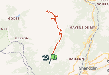
Tour Wandern von 15,1 km verfügbar auf Wallis, Gundis, Gundis. Diese Tour wird von duamerg vorgeschlagen.
Beschreibung
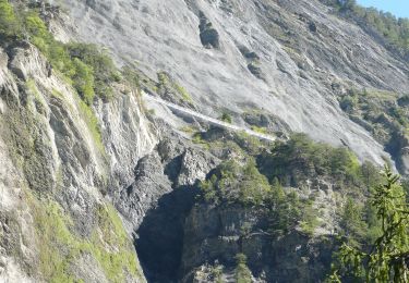
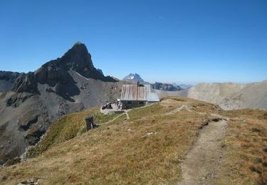
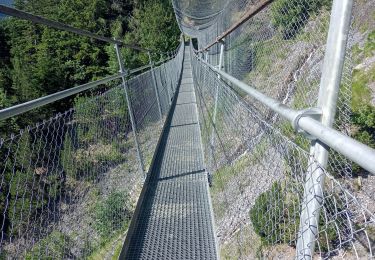
Prendre la route du col du Sanetsch jusqu'à Daillon. Monter aux Mayens de Conthey jusqu'à Codo et le départ de nombreuses courses. Laisser la voiture. Chemin bien balisé et facile par l'étang de trente pas jusqu'au col de la Croix de la Châ. Retour par le même chemin.
Ort
Land:
Switzerland
Region :
Wallis
Abteilung/Provinz :
Gundis
Kommune :
Gundis
Standort:
Unknown
Gehen Sie:(Dec)
Gehen Sie:(UTM)
367045 ; 5123507 (32T) N.
Kommentare
Touren in der Umgebung
![Tour Zu Fuß Savièse - Bisse de Savièse (Torrent-Neuf) - Photo](https://media.geolcdn.com/t/375/260/2abdaf10-00a9-4b07-a19f-cc4e4efb285c.jpeg&format=jpg&maxdim=2)
![Zu Fuß Zu Fuß](https://static1.geolcdn.com/sitytour/trail-icons/100.png)
Bisse de Savièse (Torrent-Neuf)
Zu Fuß
Einfach
Savièse,
Wallis,
Sitten,
Switzerland
![](/images/other/stat-length.png)
4,5 km | 7,4 km-effort
1h 41min
![](https://static1.geolcdn.com/siteimages/upload/files/16400158638029165_repeat_loop_refresh_sync_direction_icon.png)
Nein
![Tour Zu Fuß Ardon - Chemin des berges du Rhône - Photo](https://media.geolcdn.com/t/375/260/134426cf-485a-4873-985c-cf3c80bda5e1.jpeg&format=jpg&maxdim=2)
![Zu Fuß Zu Fuß](https://static1.geolcdn.com/sitytour/trail-icons/100.png)
Chemin des berges du Rhône
Zu Fuß
Einfach
Ardon,
Wallis,
Gundis,
Switzerland
![](/images/other/stat-length.png)
4,4 km | 4,9 km-effort
1h 6min
![](https://static1.geolcdn.com/siteimages/upload/files/16400158638029165_repeat_loop_refresh_sync_direction_icon.png)
Nein
![Tour Zu Fuß Gundis - Bisse de la Tsandra - Photo](https://media.geolcdn.com/t/375/260/1657d19d-aa60-4f9b-8a51-722366c997ed.jpeg&format=jpg&maxdim=2)
![Zu Fuß Zu Fuß](https://static1.geolcdn.com/sitytour/trail-icons/100.png)
Bisse de la Tsandra
Zu Fuß
Einfach
Gundis,
Wallis,
Gundis,
Switzerland
![](/images/other/stat-length.png)
7,4 km | 10,5 km-effort
2h 23min
![](https://static1.geolcdn.com/siteimages/upload/files/16400158638029165_repeat_loop_refresh_sync_direction_icon.png)
Nein
![Tour Wandern Sitten - Tour du Massif des Muverans - Photo](https://media.geolcdn.com/t/375/260/ext.jpg?maxdim=2&url=https%3A%2F%2Fservices.sitytrail.com%2FGeolivesWS%2FDownloadMedia.ashx%3FTrailID%3D25683%26Media%3Dimage10.JPG)
![Wandern Wandern](https://static1.geolcdn.com/sitytour/trail-icons/101.png)
Tour du Massif des Muverans
Wandern
Sehr leicht
Sitten,
Wallis,
Sitten,
Switzerland
![](/images/other/stat-length.png)
6,2 km | 14,1 km-effort
22h 11min
![](https://static1.geolcdn.com/siteimages/upload/files/16400158638029165_repeat_loop_refresh_sync_direction_icon.png)
Nein
![Tour Wandern Savièse - bises de torrent neuf - Photo](https://media.geolcdn.com/t/375/260/1deb4bd3-f63a-40cf-92d1-fa0b5d331200.jpg&format=jpg&maxdim=2)
![Wandern Wandern](https://static1.geolcdn.com/sitytour/trail-icons/101.png)
bises de torrent neuf
Wandern
Medium
Savièse,
Wallis,
Sitten,
Switzerland
![](/images/other/stat-length.png)
9,9 km | 16 km-effort
4h 12min
![](https://static1.geolcdn.com/siteimages/upload/files/16400158638029165_repeat_loop_refresh_sync_direction_icon.png)
Ja
![Tour Andere Aktivitäten Gundis - st_bg_conthey - Photo](https://media.geolcdn.com/t/375/260/ext.jpg?maxdim=2&url=https%3A%2F%2Fstatic1.geolcdn.com%2Fsiteimages%2Fupload%2Ffiles%2F1545311037marcheuse_200dpi.jpg)
![Andere Aktivitäten Andere Aktivitäten](https://static1.geolcdn.com/sitytour/trail-icons/900.png)
st_bg_conthey
Andere Aktivitäten
Sehr leicht
Gundis,
Wallis,
Gundis,
Switzerland
![](/images/other/stat-length.png)
22 km | 42 km-effort
9h 21min
![](https://static1.geolcdn.com/siteimages/upload/files/16400158638029165_repeat_loop_refresh_sync_direction_icon.png)
Nein
![Tour Wandern Gundis - huetten_02 - Photo](https://media.geolcdn.com/t/375/260/ext.jpg?maxdim=2&url=https%3A%2F%2Fstatic1.geolcdn.com%2Fsiteimages%2Fupload%2Ffiles%2F1553511878bg_sport_marche.png)
![Wandern Wandern](https://static1.geolcdn.com/sitytour/trail-icons/101.png)
huetten_02
Wandern
Sehr leicht
Gundis,
Wallis,
Gundis,
Switzerland
![](/images/other/stat-length.png)
50 km | 102 km-effort
16h 52min
![](https://static1.geolcdn.com/siteimages/upload/files/16400158638029165_repeat_loop_refresh_sync_direction_icon.png)
Ja
![Wandern Wandern](https://static1.geolcdn.com/sitytour/trail-icons/101.png)
Trajet du 29.10.21
Wandern
Sehr schwierig
Gundis,
Wallis,
Gundis,
Switzerland
![](/images/other/stat-length.png)
19,5 km | 38 km-effort
8h 42min
![](https://static1.geolcdn.com/siteimages/upload/files/16400158638029165_repeat_loop_refresh_sync_direction_icon.png)
Ja
![Tour Nordic Walking Savièse - bisse torrent neuf - Photo](https://media.geolcdn.com/t/375/260/ext.jpg?maxdim=2&url=https%3A%2F%2Fstatic1.geolcdn.com%2Fsiteimages%2Fupload%2Ffiles%2F1545311037marcheuse_200dpi.jpg)
![Nordic Walking Nordic Walking](https://static1.geolcdn.com/sitytour/trail-icons/102.png)
bisse torrent neuf
Nordic Walking
Einfach
Savièse,
Wallis,
Sitten,
Switzerland
![](/images/other/stat-length.png)
9,1 km | 14,2 km-effort
3h 20min
![](https://static1.geolcdn.com/siteimages/upload/files/16400158638029165_repeat_loop_refresh_sync_direction_icon.png)
Ja