![](/images/other/stat-length.png)
![Tour Wandern Lugano - Mte Bré -Gandria - Lugano - Photo](https://media.geolcdn.com/t/1900/400/ext.pjpeg?maxdim=2&url=https%3A%2F%2Fstatic1.geolcdn.com%2Fsiteimages%2Fupload%2Ffiles%2F1553511878bg_sport_marche.png)
Mte Bré -Gandria - Lugano
duamerg
Benutzer
![Länge](/images/other/stat-length.png)
Länge
7,2 km
![Maximale Höhe](https://static1.geolcdn.com/siteimages/upload/files/1508320355ic_sort_altitude_max_24dp.png)
Maximale Höhe
923 m
![Positive Höhendifferenz](https://static1.geolcdn.com/siteimages/upload/files/1508320355ic_sort_den_pos_24dp.png)
Positive Höhendifferenz
108 m
![Km-Effort](/images/other/stat-length.png)
Km-Effort
10,8 km
![Min. Höhe](https://static1.geolcdn.com/siteimages/upload/files/1508320355ic_sort_altitude_min_24dp.png)
Min. Höhe
272 m
![Negative Höhendifferenz](https://static1.geolcdn.com/siteimages/upload/files/1508320355ic_sort_den_neg_24dp.png)
Negative Höhendifferenz
733 m
![Boucle](https://static1.geolcdn.com/siteimages/upload/files/16400158638029165_repeat_loop_refresh_sync_direction_icon.png)
Boucle
Nein
Erstellungsdatum :
2014-12-11 00:00:00.0
Letzte Änderung :
2020-01-30 13:58:41.561
![Wandern](https://static1.geolcdn.com/sitytour/trail-icons/101.png)
2h05
Schwierigkeit : Einfach
![Scannen Sie diesen QR-Code, um die Tour in der SityTrail-Anwendung zu öffnen](https://capi.geolives.com/qq0zvz2zws4bq2lad0pu/sitytour/trails/22034/qr.png?size=200)
Kostenlosegpshiking-Anwendung
Über SityTrail
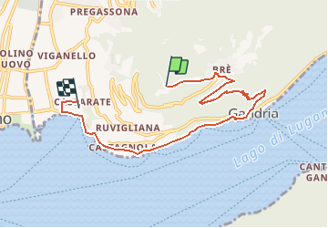
Tour Wandern von 7,2 km verfügbar auf Tessin, Bezirk Lugano, Lugano. Diese Tour wird von duamerg vorgeschlagen.
Beschreibung
prendre le funiculaire pour le Mte Bré. Descendre les marches jusqu'à Bré puis descente jusqu'à Gandria. Suivre le lac puis la route!!! pour rejoindre Lugano.
Ort
Land:
Switzerland
Region :
Tessin
Abteilung/Provinz :
Bezirk Lugano
Kommune :
Lugano
Standort:
Circolo di Lugano est
Gehen Sie:(Dec)
Gehen Sie:(UTM)
498941 ; 5095069 (32T) N.
Kommentare
Touren in der Umgebung
![Tour Wandern Lugano - Circuit decouverte Lugano - Photo](https://media.geolcdn.com/t/375/260/6dbbeef0-99d8-4d7f-9738-752dea3e067a.jpg&format=jpg&maxdim=2)
![Wandern Wandern](https://static1.geolcdn.com/sitytour/trail-icons/101.png)
Circuit decouverte Lugano
Wandern
Medium
Lugano,
Tessin,
Bezirk Lugano,
Switzerland
![](/images/other/stat-length.png)
25 km | 40 km-effort
5h 42min
![](https://static1.geolcdn.com/siteimages/upload/files/16400158638029165_repeat_loop_refresh_sync_direction_icon.png)
Ja
![Tour Zu Fuß Paradiso - Paradiso-San Salvatore - Photo](https://media.geolcdn.com/t/375/260/fedc3566-7bd8-42a8-a1ce-221aef3a3493.jpeg&format=jpg&maxdim=2)
![Zu Fuß Zu Fuß](https://static1.geolcdn.com/sitytour/trail-icons/100.png)
Paradiso-San Salvatore
Zu Fuß
Einfach
Paradiso,
Tessin,
Bezirk Lugano,
Switzerland
![](/images/other/stat-length.png)
3,2 km | 9,1 km-effort
2h 3min
![](https://static1.geolcdn.com/siteimages/upload/files/16400158638029165_repeat_loop_refresh_sync_direction_icon.png)
Nein
![Tour Andere Aktivitäten Paradiso - y10_hoehenweg_luganersee - Photo](https://media.geolcdn.com/t/375/260/ext.jpg?maxdim=2&url=https%3A%2F%2Fstatic1.geolcdn.com%2Fsiteimages%2Fupload%2Ffiles%2F1545311037marcheuse_200dpi.jpg)
![Andere Aktivitäten Andere Aktivitäten](https://static1.geolcdn.com/sitytour/trail-icons/900.png)
y10_hoehenweg_luganersee
Andere Aktivitäten
Sehr leicht
Paradiso,
Tessin,
Bezirk Lugano,
Switzerland
![](/images/other/stat-length.png)
12,2 km | 22 km-effort
5h 16min
![](https://static1.geolcdn.com/siteimages/upload/files/16400158638029165_repeat_loop_refresh_sync_direction_icon.png)
Nein
![Tour Andere Aktivitäten Lugano - y10_monte_boglia - Photo](https://media.geolcdn.com/t/375/260/ext.jpg?maxdim=2&url=https%3A%2F%2Fstatic1.geolcdn.com%2Fsiteimages%2Fupload%2Ffiles%2F1545311037marcheuse_200dpi.jpg)
![Andere Aktivitäten Andere Aktivitäten](https://static1.geolcdn.com/sitytour/trail-icons/900.png)
y10_monte_boglia
Andere Aktivitäten
Sehr leicht
Lugano,
Tessin,
Bezirk Lugano,
Switzerland
![](/images/other/stat-length.png)
13,1 km | 32 km-effort
7h 5min
![](https://static1.geolcdn.com/siteimages/upload/files/16400158638029165_repeat_loop_refresh_sync_direction_icon.png)
Nein
![Tour Mountainbike Lugano - Bike32933 - Photo](https://media.geolcdn.com/t/375/260/ext.jpg?maxdim=2&url=https%3A%2F%2Fstatic1.geolcdn.com%2Fsiteimages%2Fupload%2Ffiles%2F1524743154velo.jpg)
![Mountainbike Mountainbike](https://static1.geolcdn.com/sitytour/trail-icons/202.png)
Bike32933
Mountainbike
Sehr leicht
Lugano,
Tessin,
Bezirk Lugano,
Switzerland
![](/images/other/stat-length.png)
25 km | 38 km-effort
Unbekannt
![](https://static1.geolcdn.com/siteimages/upload/files/16400158638029165_repeat_loop_refresh_sync_direction_icon.png)
Ja
![Tour Wandern Paradiso - Paradiso - San Salvatore - Carona - Morcote - Photo](https://media.geolcdn.com/t/375/260/ext.jpg?maxdim=2&url=https%3A%2F%2Fstatic1.geolcdn.com%2Fsiteimages%2Fupload%2Ffiles%2F1553511878bg_sport_marche.png)
![Wandern Wandern](https://static1.geolcdn.com/sitytour/trail-icons/101.png)
Paradiso - San Salvatore - Carona - Morcote
Wandern
Sehr leicht
Paradiso,
Tessin,
Bezirk Lugano,
Switzerland
![](/images/other/stat-length.png)
11,3 km | 19,9 km-effort
Unbekannt
![](https://static1.geolcdn.com/siteimages/upload/files/16400158638029165_repeat_loop_refresh_sync_direction_icon.png)
Nein
![Tour Wandern Lugano - YHH131 Lugano - Tesserete - Photo](https://media.geolcdn.com/t/375/260/ext.jpg?maxdim=2&url=https%3A%2F%2Fstatic1.geolcdn.com%2Fsiteimages%2Fupload%2Ffiles%2F1553511878bg_sport_marche.png)
![Wandern Wandern](https://static1.geolcdn.com/sitytour/trail-icons/101.png)
YHH131 Lugano - Tesserete
Wandern
Schwierig
Lugano,
Tessin,
Bezirk Lugano,
Switzerland
![](/images/other/stat-length.png)
10,3 km | 15,8 km-effort
3h 52min
![](https://static1.geolcdn.com/siteimages/upload/files/16400158638029165_repeat_loop_refresh_sync_direction_icon.png)
Nein
![Tour Wandern Lugano - S.Salvatore- Morcote - Photo](https://media.geolcdn.com/t/375/260/ext.jpg?maxdim=2&url=https%3A%2F%2Fstatic1.geolcdn.com%2Fsiteimages%2Fupload%2Ffiles%2F1553511878bg_sport_marche.png)
![Wandern Wandern](https://static1.geolcdn.com/sitytour/trail-icons/101.png)
S.Salvatore- Morcote
Wandern
Einfach
Lugano,
Tessin,
Bezirk Lugano,
Switzerland
![](/images/other/stat-length.png)
9,4 km | 13,7 km-effort
3h 0min
![](https://static1.geolcdn.com/siteimages/upload/files/16400158638029165_repeat_loop_refresh_sync_direction_icon.png)
Nein
![Tour Andere Aktivitäten Lugano - TI / brè - monte boglia - alpe bolla - brè - Photo](https://media.geolcdn.com/t/375/260/ext.jpg?maxdim=2&url=https%3A%2F%2Fstatic1.geolcdn.com%2Fsiteimages%2Fupload%2Ffiles%2F1545311037marcheuse_200dpi.jpg)
![Andere Aktivitäten Andere Aktivitäten](https://static1.geolcdn.com/sitytour/trail-icons/900.png)
TI / brè - monte boglia - alpe bolla - brè
Andere Aktivitäten
Sehr leicht
Lugano,
Tessin,
Bezirk Lugano,
Switzerland
![](/images/other/stat-length.png)
11,9 km | 22 km-effort
Unbekannt
![](https://static1.geolcdn.com/siteimages/upload/files/16400158638029165_repeat_loop_refresh_sync_direction_icon.png)
Ja