![](/images/other/stat-length.png)
![Tour Nordic Walking Lens - LOUVRE LENS AU STADE GUY DRUT OIGNIES- MN du 7 Septembre 2019 - Photo](https://media.geolcdn.com/t/1900/400/ext.pjpeg?maxdim=2&url=https%3A%2F%2Fstatic1.geolcdn.com%2Fsiteimages%2Fupload%2Ffiles%2F1545311037marcheuse_200dpi.jpg)
LOUVRE LENS AU STADE GUY DRUT OIGNIES- MN du 7 Septembre 2019
dehemjacques
Benutzer
![Länge](/images/other/stat-length.png)
Länge
20 km
![Maximale Höhe](https://static1.geolcdn.com/siteimages/upload/files/1508320355ic_sort_altitude_max_24dp.png)
Maximale Höhe
44 m
![Positive Höhendifferenz](https://static1.geolcdn.com/siteimages/upload/files/1508320355ic_sort_den_pos_24dp.png)
Positive Höhendifferenz
120 m
![Km-Effort](/images/other/stat-length.png)
Km-Effort
22 km
![Min. Höhe](https://static1.geolcdn.com/siteimages/upload/files/1508320355ic_sort_altitude_min_24dp.png)
Min. Höhe
16 m
![Negative Höhendifferenz](https://static1.geolcdn.com/siteimages/upload/files/1508320355ic_sort_den_neg_24dp.png)
Negative Höhendifferenz
130 m
![Boucle](https://static1.geolcdn.com/siteimages/upload/files/16400158638029165_repeat_loop_refresh_sync_direction_icon.png)
Boucle
Nein
Erstellungsdatum :
2019-09-01 12:55:01.91
Letzte Änderung :
2019-09-01 12:58:15.971
![Nordic Walking](https://static1.geolcdn.com/sitytour/trail-icons/102.png)
3h20
Schwierigkeit : Einfach
![Scannen Sie diesen QR-Code, um die Tour in der SityTrail-Anwendung zu öffnen](https://capi.geolives.com/qq0zvz2zws4bq2lad0pu/sitytour/trails/2188448/qr.png?size=200)
Kostenlosegpshiking-Anwendung
Über SityTrail
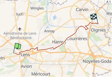
Tour Nordic Walking von 20 km verfügbar auf Nordfrankreich, Pas-de-Calais, Lens. Diese Tour wird von dehemjacques vorgeschlagen.
Beschreibung
Départ devant l'entrée de la galerie du temps du musée du Louvre Lens,
parc de l'Université, Parc de Loison sous Lens, Canal de la Souchez par bois de Flormimont, Gare d'eau de Carvin et arrivée sur le stade Guy Drut d'Oignies
Ort
Land:
France
Region :
Nordfrankreich
Abteilung/Provinz :
Pas-de-Calais
Kommune :
Lens
Standort:
Unknown
Gehen Sie:(Dec)
Gehen Sie:(UTM)
486226 ; 5586610 (31U) N.
Kommentare
Touren in der Umgebung
![Tour Wandern Méricourt - MERICOURT DECOUVERTE 1er partie - Photo](https://media.geolcdn.com/t/375/260/ext.jpg?maxdim=2&url=https%3A%2F%2Fservices.sitytrail.com%2FGeolivesWS%2FDownloadMedia.ashx%3FTrailID%3D549775%26Media%3D5ec0ec93-40c4-429d-a014-42abc8f28d68.jpg)
![Wandern Wandern](https://static1.geolcdn.com/sitytour/trail-icons/101.png)
MERICOURT DECOUVERTE 1er partie
Wandern
Sehr leicht
Méricourt,
Nordfrankreich,
Pas-de-Calais,
France
![](/images/other/stat-length.png)
8,1 km | 8,7 km-effort
1h 57min
![](https://static1.geolcdn.com/siteimages/upload/files/16400158638029165_repeat_loop_refresh_sync_direction_icon.png)
Ja
![Tour Wandern Liévin - 50 km Lievin en nocturne - Photo](https://media.geolcdn.com/t/375/260/ext.jpg?maxdim=2&url=https%3A%2F%2Fstatic1.geolcdn.com%2Fsiteimages%2Fupload%2Ffiles%2F1553511878bg_sport_marche.png)
![Wandern Wandern](https://static1.geolcdn.com/sitytour/trail-icons/101.png)
50 km Lievin en nocturne
Wandern
Sehr schwierig
(1)
Liévin,
Nordfrankreich,
Pas-de-Calais,
France
![](/images/other/stat-length.png)
52 km | 61 km-effort
9h 0min
![](https://static1.geolcdn.com/siteimages/upload/files/16400158638029165_repeat_loop_refresh_sync_direction_icon.png)
Ja
![Tour Wandern Lens - randonnée - Photo](https://media.geolcdn.com/t/375/260/4f8e0b82-df89-47b1-be2a-b1e08dad4aee.jpg&format=jpg&maxdim=2)
![Wandern Wandern](https://static1.geolcdn.com/sitytour/trail-icons/101.png)
randonnée
Wandern
Schwierig
Lens,
Nordfrankreich,
Pas-de-Calais,
France
![](/images/other/stat-length.png)
10,5 km | 13,4 km-effort
3h 41min
![](https://static1.geolcdn.com/siteimages/upload/files/16400158638029165_repeat_loop_refresh_sync_direction_icon.png)
Ja
![Tour Wandern Angres - randonnée pinchonvalles - Photo](https://media.geolcdn.com/t/375/260/b2891722-43d7-4acf-b8f9-14f5909069c3.jpg&format=jpg&maxdim=2)
![Wandern Wandern](https://static1.geolcdn.com/sitytour/trail-icons/101.png)
randonnée pinchonvalles
Wandern
Sehr schwierig
Angres,
Nordfrankreich,
Pas-de-Calais,
France
![](/images/other/stat-length.png)
27 km | 0 m-effort
3h 24min
![](https://static1.geolcdn.com/siteimages/upload/files/16400158638029165_repeat_loop_refresh_sync_direction_icon.png)
Nein
![Tour Andere Aktivitäten Liévin - boucle Liévin - Photo](https://media.geolcdn.com/t/375/260/ext.jpg?maxdim=2&url=https%3A%2F%2Fservices.sitytrail.com%2FGeolivesWS%2FDownloadMedia.ashx%3FTrailID%3D956017%26Media%3D20180429102202.jpg)
![Andere Aktivitäten Andere Aktivitäten](https://static1.geolcdn.com/sitytour/trail-icons/900.png)
boucle Liévin
Andere Aktivitäten
Sehr leicht
Liévin,
Nordfrankreich,
Pas-de-Calais,
France
![](/images/other/stat-length.png)
11 km | 12,3 km-effort
2h 2min
![](https://static1.geolcdn.com/siteimages/upload/files/16400158638029165_repeat_loop_refresh_sync_direction_icon.png)
Ja
![Tour Andere Aktivitäten Liévin - boucle Liévin - Photo](https://media.geolcdn.com/t/375/260/ext.jpg?maxdim=2&url=https%3A%2F%2Fservices.sitytrail.com%2FGeolivesWS%2FDownloadMedia.ashx%3FTrailID%3D953687%26Media%3D20180429102202.jpg)
![Andere Aktivitäten Andere Aktivitäten](https://static1.geolcdn.com/sitytour/trail-icons/900.png)
boucle Liévin
Andere Aktivitäten
Sehr leicht
Liévin,
Nordfrankreich,
Pas-de-Calais,
France
![](/images/other/stat-length.png)
11 km | 12,3 km-effort
2h 2min
![](https://static1.geolcdn.com/siteimages/upload/files/16400158638029165_repeat_loop_refresh_sync_direction_icon.png)
Ja
![Tour Wandern Méricourt - MERICOURT DECOUVERTE 1er partie - Photo](https://media.geolcdn.com/t/375/260/ext.jpg?maxdim=2&url=https%3A%2F%2Fservices.sitytrail.com%2FGeolivesWS%2FDownloadMedia.ashx%3FTrailID%3D485439%26Media%3Ddc7302f6-aac9-43a5-b656-8d2fb1c1d13c.JPG)
![Wandern Wandern](https://static1.geolcdn.com/sitytour/trail-icons/101.png)
MERICOURT DECOUVERTE 1er partie
Wandern
Sehr leicht
Méricourt,
Nordfrankreich,
Pas-de-Calais,
France
![](/images/other/stat-length.png)
8,1 km | 8,7 km-effort
2h 41min
![](https://static1.geolcdn.com/siteimages/upload/files/16400158638029165_repeat_loop_refresh_sync_direction_icon.png)
Ja
![Tour Wandern Méricourt - Mericourt découverte - Photo](https://media.geolcdn.com/t/375/260/ext.jpg?maxdim=2&url=https%3A%2F%2Fservices.sitytrail.com%2FGeolivesWS%2FDownloadMedia.ashx%3FTrailID%3D351103%26Media%3D20141004162428.jpg)
![Wandern Wandern](https://static1.geolcdn.com/sitytour/trail-icons/101.png)
Mericourt découverte
Wandern
Sehr leicht
Méricourt,
Nordfrankreich,
Pas-de-Calais,
France
![](/images/other/stat-length.png)
11,1 km | 12 km-effort
2h 26min
![](https://static1.geolcdn.com/siteimages/upload/files/16400158638029165_repeat_loop_refresh_sync_direction_icon.png)
Nein
![Tour Wandern Souchez - Souchez-Noulette-Lorette-Ablain - Photo](https://media.geolcdn.com/t/375/260/ext.jpg?maxdim=2&url=https%3A%2F%2Fservices.sitytrail.com%2FGeolivesWS%2FDownloadMedia.ashx%3FTrailID%3D173056%26Media%3D14580_6.jpg)
![Wandern Wandern](https://static1.geolcdn.com/sitytour/trail-icons/101.png)
Souchez-Noulette-Lorette-Ablain
Wandern
Einfach
Souchez,
Nordfrankreich,
Pas-de-Calais,
France
![](/images/other/stat-length.png)
6,7 km | 8,4 km-effort
1h 45min
![](https://static1.geolcdn.com/siteimages/upload/files/16400158638029165_repeat_loop_refresh_sync_direction_icon.png)
Ja
dommage qu'il n'y a pas de voie verte à travers Lens. 3kms de trottoirs pour sortir de Lens et rejoindre Loison