![](/images/other/stat-length.png)
![Tour Wandern Moustiers-Sainte-Marie - le pavillon Venascle - Photo](https://media.geolcdn.com/t/1900/400/026547a2-e561-4a7f-8ad8-9a9e7c1cd34f.jpg&format=pjpeg&maxdim=2)
le pavillon Venascle
marchev
Benutzer
![Länge](/images/other/stat-length.png)
Länge
13,9 km
![Maximale Höhe](https://static1.geolcdn.com/siteimages/upload/files/1508320355ic_sort_altitude_max_24dp.png)
Maximale Höhe
1615 m
![Positive Höhendifferenz](https://static1.geolcdn.com/siteimages/upload/files/1508320355ic_sort_den_pos_24dp.png)
Positive Höhendifferenz
679 m
![Km-Effort](/images/other/stat-length.png)
Km-Effort
23 km
![Min. Höhe](https://static1.geolcdn.com/siteimages/upload/files/1508320355ic_sort_altitude_min_24dp.png)
Min. Höhe
951 m
![Negative Höhendifferenz](https://static1.geolcdn.com/siteimages/upload/files/1508320355ic_sort_den_neg_24dp.png)
Negative Höhendifferenz
681 m
![Boucle](https://static1.geolcdn.com/siteimages/upload/files/16400158638029165_repeat_loop_refresh_sync_direction_icon.png)
Boucle
Ja
Erstellungsdatum :
2019-08-30 08:05:16.12
Letzte Änderung :
2019-08-31 05:07:02.46
![Wandern](https://static1.geolcdn.com/sitytour/trail-icons/101.png)
6h04
Schwierigkeit : Schwierig
![Scannen Sie diesen QR-Code, um die Tour in der SityTrail-Anwendung zu öffnen](https://capi.geolives.com/qq0zvz2zws4bq2lad0pu/sitytour/trails/2186745/qr.png?size=200)
Kostenlosegpshiking-Anwendung
Über SityTrail
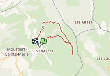
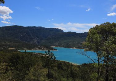
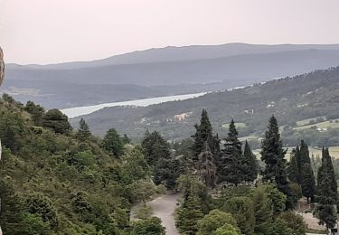
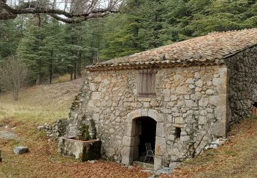
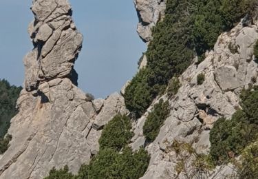
Tour Wandern von 13,9 km verfügbar auf Provence-Alpes-Côte d'Azur, Alpes-de-Haute-Provence, Moustiers-Sainte-Marie. Diese Tour wird von marchev vorgeschlagen.
Beschreibung
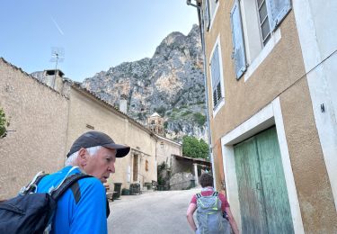
Départ du Parking des Plaines Venascle. Trés jolie randonnée avec au sommet une belle vue sur les Mourres et au sommet du Pavillon sur le lac de Sainte CroiX.
La descente est pénible et demande de l'attention
Ort
Land:
France
Region :
Provence-Alpes-Côte d'Azur
Abteilung/Provinz :
Alpes-de-Haute-Provence
Kommune :
Moustiers-Sainte-Marie
Standort:
Unknown
Gehen Sie:(Dec)
Gehen Sie:(UTM)
278735 ; 4858817 (32T) N.
Kommentare
Touren in der Umgebung
![Tour Wandern Moustiers-Sainte-Marie - Tour des Gorges du Verdon - Photo](https://media.geolcdn.com/t/375/260/ext.jpg?maxdim=2&url=https%3A%2F%2Fstatic1.geolcdn.com%2Fsiteimages%2Fupload%2Ffiles%2F1553511878bg_sport_marche.png)
![Wandern Wandern](https://static1.geolcdn.com/sitytour/trail-icons/101.png)
Tour des Gorges du Verdon
Wandern
Schwierig
(5)
Moustiers-Sainte-Marie,
Provence-Alpes-Côte d'Azur,
Alpes-de-Haute-Provence,
France
![](/images/other/stat-length.png)
89 km | 126 km-effort
Unbekannt
![](https://static1.geolcdn.com/siteimages/upload/files/16400158638029165_repeat_loop_refresh_sync_direction_icon.png)
Ja
![Tour Wandern Moustiers-Sainte-Marie - Moustier Ravin Notre Dame crête de l’Ourbes 14,5 km - Photo](https://media.geolcdn.com/t/375/260/a74da90b-306e-4ee3-bd53-9babe310e6e2.jpg&format=jpg&maxdim=2)
![Wandern Wandern](https://static1.geolcdn.com/sitytour/trail-icons/101.png)
Moustier Ravin Notre Dame crête de l’Ourbes 14,5 km
Wandern
Schwierig
Moustiers-Sainte-Marie,
Provence-Alpes-Côte d'Azur,
Alpes-de-Haute-Provence,
France
![](/images/other/stat-length.png)
14,6 km | 26 km-effort
6h 43min
![](https://static1.geolcdn.com/siteimages/upload/files/16400158638029165_repeat_loop_refresh_sync_direction_icon.png)
Nein
![Tour Wandern Moustiers-Sainte-Marie - 2023-02-14 Les grottes de Saint Maurin - Photo](https://media.geolcdn.com/t/375/260/ff240215-b004-40c4-b632-ab00d837cb62.jpg&format=jpg&maxdim=2)
![Wandern Wandern](https://static1.geolcdn.com/sitytour/trail-icons/101.png)
2023-02-14 Les grottes de Saint Maurin
Wandern
Einfach
Moustiers-Sainte-Marie,
Provence-Alpes-Côte d'Azur,
Alpes-de-Haute-Provence,
France
![](/images/other/stat-length.png)
7,5 km | 12,2 km-effort
4h 11min
![](https://static1.geolcdn.com/siteimages/upload/files/16400158638029165_repeat_loop_refresh_sync_direction_icon.png)
Ja
![Tour Wandern Moustiers-Sainte-Marie - Moustier saine Marie 11,4 km - Photo](https://media.geolcdn.com/t/375/260/325a0dcc-1ff8-4d2c-a406-91140305788f.jpeg&format=jpg&maxdim=2)
![Wandern Wandern](https://static1.geolcdn.com/sitytour/trail-icons/101.png)
Moustier saine Marie 11,4 km
Wandern
Medium
Moustiers-Sainte-Marie,
Provence-Alpes-Côte d'Azur,
Alpes-de-Haute-Provence,
France
![](/images/other/stat-length.png)
11,4 km | 17,7 km-effort
4h 16min
![](https://static1.geolcdn.com/siteimages/upload/files/16400158638029165_repeat_loop_refresh_sync_direction_icon.png)
Ja
![Tour Wandern Moustiers-Sainte-Marie - Moutiers Sainte Marie - Voie Romaine vers Vénascle - Photo](https://media.geolcdn.com/t/375/260/f43e62cf-b80e-49c9-83f1-1f2cdcff5d1b.jpg&format=jpg&maxdim=2)
![Wandern Wandern](https://static1.geolcdn.com/sitytour/trail-icons/101.png)
Moutiers Sainte Marie - Voie Romaine vers Vénascle
Wandern
Medium
Moustiers-Sainte-Marie,
Provence-Alpes-Côte d'Azur,
Alpes-de-Haute-Provence,
France
![](/images/other/stat-length.png)
7,7 km | 12,5 km-effort
2h 40min
![](https://static1.geolcdn.com/siteimages/upload/files/16400158638029165_repeat_loop_refresh_sync_direction_icon.png)
Ja
![Tour Wandern Moustiers-Sainte-Marie - Autour de Moustiers st Marie - Photo](https://media.geolcdn.com/t/375/260/ext.jpg?maxdim=2&url=https%3A%2F%2Fservices.sitytrail.com%2FGeolivesWS%2FDownloadMedia.ashx%3FTrailID%3D820131%26Media%3D24900497-3777-4a34-815d-aa485e7dbccc.JPG)
![Wandern Wandern](https://static1.geolcdn.com/sitytour/trail-icons/101.png)
Autour de Moustiers st Marie
Wandern
Medium
Moustiers-Sainte-Marie,
Provence-Alpes-Côte d'Azur,
Alpes-de-Haute-Provence,
France
![](/images/other/stat-length.png)
13,7 km | 18,8 km-effort
4h 0min
![](https://static1.geolcdn.com/siteimages/upload/files/16400158638029165_repeat_loop_refresh_sync_direction_icon.png)
Ja
![Tour Wandern Moustiers-Sainte-Marie - moustiers ste Marie - Photo](https://media.geolcdn.com/t/375/260/91116718-bfd8-4bd6-8abb-af72a3de0c85.jpg&format=jpg&maxdim=2)
![Wandern Wandern](https://static1.geolcdn.com/sitytour/trail-icons/101.png)
moustiers ste Marie
Wandern
Medium
Moustiers-Sainte-Marie,
Provence-Alpes-Côte d'Azur,
Alpes-de-Haute-Provence,
France
![](/images/other/stat-length.png)
4,4 km | 7,8 km-effort
1h 20min
![](https://static1.geolcdn.com/siteimages/upload/files/16400158638029165_repeat_loop_refresh_sync_direction_icon.png)
Ja
![Tour Wandern Moustiers-Sainte-Marie - moustier mont deniers 18k 100m - Photo](https://media.geolcdn.com/t/375/260/8ddff121-5caf-44e2-ae18-5659b34b6078.jpg&format=jpg&maxdim=2)
![Wandern Wandern](https://static1.geolcdn.com/sitytour/trail-icons/101.png)
moustier mont deniers 18k 100m
Wandern
Sehr schwierig
Moustiers-Sainte-Marie,
Provence-Alpes-Côte d'Azur,
Alpes-de-Haute-Provence,
France
![](/images/other/stat-length.png)
17,5 km | 30 km-effort
7h 53min
![](https://static1.geolcdn.com/siteimages/upload/files/16400158638029165_repeat_loop_refresh_sync_direction_icon.png)
Nein
![Tour Wandern Moustiers-Sainte-Marie - 2023-10-03 Naverre-Cascade du Riou-Marignol - Photo](https://media.geolcdn.com/t/375/260/cca55c37-c9d5-4f62-8c9c-de8910f158bb.jpg&format=jpg&maxdim=2)
![Wandern Wandern](https://static1.geolcdn.com/sitytour/trail-icons/101.png)
2023-10-03 Naverre-Cascade du Riou-Marignol
Wandern
Medium
Moustiers-Sainte-Marie,
Provence-Alpes-Côte d'Azur,
Alpes-de-Haute-Provence,
France
![](/images/other/stat-length.png)
10,2 km | 15,9 km-effort
3h 24min
![](https://static1.geolcdn.com/siteimages/upload/files/16400158638029165_repeat_loop_refresh_sync_direction_icon.png)
Ja