![](/images/other/stat-length.png)
![Tour Wandern Ottrott - klingenthal mont saint Odile - Photo](https://media.geolcdn.com/t/1900/400/ext.pjpeg?maxdim=2&url=https%3A%2F%2Fmedia.geolcdn.com%2Ff%2F2386bced-8d80-4ffd-ad70-69f75c4beaa9.jpg)
klingenthal mont saint Odile
BernardThiry
Benutzer
![Länge](/images/other/stat-length.png)
Länge
13,9 km
![Maximale Höhe](https://static1.geolcdn.com/siteimages/upload/files/1508320355ic_sort_altitude_max_24dp.png)
Maximale Höhe
769 m
![Positive Höhendifferenz](https://static1.geolcdn.com/siteimages/upload/files/1508320355ic_sort_den_pos_24dp.png)
Positive Höhendifferenz
554 m
![Km-Effort](/images/other/stat-length.png)
Km-Effort
21 km
![Min. Höhe](https://static1.geolcdn.com/siteimages/upload/files/1508320355ic_sort_altitude_min_24dp.png)
Min. Höhe
324 m
![Negative Höhendifferenz](https://static1.geolcdn.com/siteimages/upload/files/1508320355ic_sort_den_neg_24dp.png)
Negative Höhendifferenz
551 m
![Boucle](https://static1.geolcdn.com/siteimages/upload/files/16400158638029165_repeat_loop_refresh_sync_direction_icon.png)
Boucle
Ja
Erstellungsdatum :
2019-08-29 08:08:01.852
Letzte Änderung :
2019-08-30 07:51:12.529
![Wandern](https://static1.geolcdn.com/sitytour/trail-icons/101.png)
3h55
Schwierigkeit : Medium
![Scannen Sie diesen QR-Code, um die Tour in der SityTrail-Anwendung zu öffnen](https://capi.geolives.com/qq0zvz2zws4bq2lad0pu/sitytour/trails/2186298/qr.png?size=200)
Kostenlosegpshiking-Anwendung
Über SityTrail
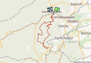
Tour Wandern von 13,9 km verfügbar auf Großer Osten, Unterelsass, Ottrott. Diese Tour wird von BernardThiry vorgeschlagen.
Beschreibung
très belle promenade qui monte au château d'Ottrott sentier des merveilles mur païen Mont Saint-Odile retour par boucle mur païen
Ort
Land:
France
Region :
Großer Osten
Abteilung/Provinz :
Unterelsass
Kommune :
Ottrott
Standort:
Unknown
Gehen Sie:(Dec)
Gehen Sie:(UTM)
382505 ; 5369381 (32U) N.
Kommentare
Touren in der Umgebung
![Tour Wandern Ottrott - Le circuit sud du Mur Païen - Photo](https://media.geolcdn.com/t/375/260/ext.jpg?maxdim=2&url=https%3A%2F%2Fservices.sitytrail.com%2FGeolivesWS%2FDownloadMedia.ashx%3FTrailID%3D771291%26Media%3Dfix__20170611121416.jpg)
![Wandern Wandern](https://static1.geolcdn.com/sitytour/trail-icons/101.png)
Le circuit sud du Mur Païen
Wandern
Einfach
(2)
Ottrott,
Großer Osten,
Unterelsass,
France
![](/images/other/stat-length.png)
4,9 km | 6,3 km-effort
1h 56min
![](https://static1.geolcdn.com/siteimages/upload/files/16400158638029165_repeat_loop_refresh_sync_direction_icon.png)
Nein
![Tour Wandern Ottrott - Le circuit nord du Mur Païen - Photo](https://media.geolcdn.com/t/375/260/ext.jpg?maxdim=2&url=https%3A%2F%2Fservices.sitytrail.com%2FGeolivesWS%2FDownloadMedia.ashx%3FTrailID%3D771290%26Media%3Dfix__20170611105927.jpg)
![Wandern Wandern](https://static1.geolcdn.com/sitytour/trail-icons/101.png)
Le circuit nord du Mur Païen
Wandern
Einfach
(1)
Ottrott,
Großer Osten,
Unterelsass,
France
![](/images/other/stat-length.png)
5,9 km | 8,5 km-effort
2h 4min
![](https://static1.geolcdn.com/siteimages/upload/files/16400158638029165_repeat_loop_refresh_sync_direction_icon.png)
Nein
![Tour Wandern Ottrott - Le Mont Sainte-Odile depuis Otrott - Photo](https://media.geolcdn.com/t/375/260/ext.jpg?maxdim=2&url=https%3A%2F%2Fservices.sitytrail.com%2FGeolivesWS%2FDownloadMedia.ashx%3FTrailID%3D506359%26Media%3Dfix__20151226143401.jpg)
![Wandern Wandern](https://static1.geolcdn.com/sitytour/trail-icons/101.png)
Le Mont Sainte-Odile depuis Otrott
Wandern
Medium
(1)
Ottrott,
Großer Osten,
Unterelsass,
France
![](/images/other/stat-length.png)
13 km | 20 km-effort
6h 18min
![](https://static1.geolcdn.com/siteimages/upload/files/16400158638029165_repeat_loop_refresh_sync_direction_icon.png)
Ja
![Tour Wandern Ottrott - Montée vers le Mont Sainte-Odile - Photo](https://media.geolcdn.com/t/375/260/ext.jpg?maxdim=2&url=https%3A%2F%2Fservices.sitytrail.com%2FGeolivesWS%2FDownloadMedia.ashx%3FTrailID%3D453779%26Media%3Dfix__20150802160011.jpg)
![Wandern Wandern](https://static1.geolcdn.com/sitytour/trail-icons/101.png)
Montée vers le Mont Sainte-Odile
Wandern
Schwierig
(1)
Ottrott,
Großer Osten,
Unterelsass,
France
![](/images/other/stat-length.png)
17,6 km | 26 km-effort
5h 52min
![](https://static1.geolcdn.com/siteimages/upload/files/16400158638029165_repeat_loop_refresh_sync_direction_icon.png)
Ja
![Tour Wandern Ottrott - Le mur païen - Photo](https://media.geolcdn.com/t/375/260/ext.jpg?maxdim=2&url=https%3A%2F%2Fservices.sitytrail.com%2FGeolivesWS%2FDownloadMedia.ashx%3FTrailID%3D355557%26Media%3Dfix__20141019162126.jpg)
![Wandern Wandern](https://static1.geolcdn.com/sitytour/trail-icons/101.png)
Le mur païen
Wandern
Medium
(4)
Ottrott,
Großer Osten,
Unterelsass,
France
![](/images/other/stat-length.png)
10,5 km | 14,5 km-effort
4h 36min
![](https://static1.geolcdn.com/siteimages/upload/files/16400158638029165_repeat_loop_refresh_sync_direction_icon.png)
Ja
![Tour Wandern Ottrott - Mur Paien complet - Photo](https://media.geolcdn.com/t/375/260/ext.jpg?maxdim=2&url=https%3A%2F%2Fservices.sitytrail.com%2FGeolivesWS%2FDownloadMedia.ashx%3FTrailID%3D257852%26Media%3Dfix__20140316152516.jpg)
![Wandern Wandern](https://static1.geolcdn.com/sitytour/trail-icons/101.png)
Mur Paien complet
Wandern
Medium
(1)
Ottrott,
Großer Osten,
Unterelsass,
France
![](/images/other/stat-length.png)
12 km | 16,4 km-effort
5h 25min
![](https://static1.geolcdn.com/siteimages/upload/files/16400158638029165_repeat_loop_refresh_sync_direction_icon.png)
Ja
![Tour Mountainbike Barr - Circuit des 3 Petits Ponts - Photo](https://media.geolcdn.com/t/375/260/ext.jpg?maxdim=2&url=https%3A%2F%2Fservices.sitytrail.com%2FGeolivesWS%2FDownloadMedia.ashx%3FTrailID%3D101124%26Media%3D611_1.jpg)
![Mountainbike Mountainbike](https://static1.geolcdn.com/sitytour/trail-icons/202.png)
Circuit des 3 Petits Ponts
Mountainbike
Schwierig
(1)
Barr,
Großer Osten,
Unterelsass,
France
![](/images/other/stat-length.png)
15,9 km | 22 km-effort
1h 19min
![](https://static1.geolcdn.com/siteimages/upload/files/16400158638029165_repeat_loop_refresh_sync_direction_icon.png)
Ja
![Tour Mountainbike Ottrott - Sainte-Odile East-Face - Photo](https://media.geolcdn.com/t/375/260/ext.jpg?maxdim=2&url=https%3A%2F%2Fservices.sitytrail.com%2FGeolivesWS%2FDownloadMedia.ashx%3FTrailID%3D100800%26Media%3D307_1.jpg)
![Mountainbike Mountainbike](https://static1.geolcdn.com/sitytour/trail-icons/202.png)
Sainte-Odile East-Face
Mountainbike
Schwierig
(1)
Ottrott,
Großer Osten,
Unterelsass,
France
![](/images/other/stat-length.png)
24 km | 39 km-effort
3h 0min
![](https://static1.geolcdn.com/siteimages/upload/files/16400158638029165_repeat_loop_refresh_sync_direction_icon.png)
Ja
![Tour Reiten Mollkirch - suuntoapp-HorsebackRiding-2024-04-28T06-24-49Z - Photo](https://media.geolcdn.com/t/375/260/ext.jpg?maxdim=2&url=https%3A%2F%2Fmedia.geolcdn.com%2Ff%2F492e641b-5f59-4751-a81d-a41633bc94a3.jpg)
![Reiten Reiten](https://static1.geolcdn.com/sitytour/trail-icons/301.png)
suuntoapp-HorsebackRiding-2024-04-28T06-24-49Z
Reiten
Schwierig
Mollkirch,
Großer Osten,
Unterelsass,
France
![](/images/other/stat-length.png)
34 km | 48 km-effort
6h 20min
![](https://static1.geolcdn.com/siteimages/upload/files/16400158638029165_repeat_loop_refresh_sync_direction_icon.png)
Ja