![](/images/other/stat-length.png)
![Tour Wandern Bièvre - Six planes 12 km (15 à l'effort) - Photo](https://media.geolcdn.com/t/1900/400/ext.pjpeg?maxdim=2&url=https%3A%2F%2Fstatic1.geolcdn.com%2Fsiteimages%2Fupload%2Ffiles%2F1553511878bg_sport_marche.png)
Six planes 12 km (15 à l'effort)
ramagufa
Benutzer
![Länge](/images/other/stat-length.png)
Länge
11,7 km
![Maximale Höhe](https://static1.geolcdn.com/siteimages/upload/files/1508320355ic_sort_altitude_max_24dp.png)
Maximale Höhe
395 m
![Positive Höhendifferenz](https://static1.geolcdn.com/siteimages/upload/files/1508320355ic_sort_den_pos_24dp.png)
Positive Höhendifferenz
329 m
![Km-Effort](/images/other/stat-length.png)
Km-Effort
16,1 km
![Min. Höhe](https://static1.geolcdn.com/siteimages/upload/files/1508320355ic_sort_altitude_min_24dp.png)
Min. Höhe
227 m
![Negative Höhendifferenz](https://static1.geolcdn.com/siteimages/upload/files/1508320355ic_sort_den_neg_24dp.png)
Negative Höhendifferenz
329 m
![Boucle](https://static1.geolcdn.com/siteimages/upload/files/16400158638029165_repeat_loop_refresh_sync_direction_icon.png)
Boucle
Ja
Erstellungsdatum :
2019-04-16 19:16:58.076
Letzte Änderung :
2019-08-27 17:13:41.644
![Wandern](https://static1.geolcdn.com/sitytour/trail-icons/101.png)
4h11
Schwierigkeit : Medium
![Scannen Sie diesen QR-Code, um die Tour in der SityTrail-Anwendung zu öffnen](https://capi.geolives.com/qq0zvz2zws4bq2lad0pu/sitytour/trails/2184771/qr.png?size=200)
Kostenlosegpshiking-Anwendung
Über SityTrail
Tour Wandern von 11,7 km verfügbar auf Wallonien, Namur, Bièvre. Diese Tour wird von ramagufa vorgeschlagen.
Beschreibung
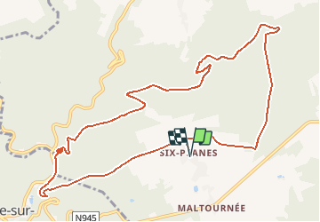
Départ de Six-Planes pour aller vers l'Ancien Moulin de Monceau.
De là prendre la direction du Pont des brebis.
Traverser les bois de Marionfontaine, Hallet et Plaimont pour descendre dans le bois de Jôminot.
Regnager Six-Planes par le sentier des Vipères.
Ort
Land:
Belgium
Region :
Wallonien
Abteilung/Provinz :
Namur
Kommune :
Bièvre
Standort:
Gros-Fays
Gehen Sie:(Dec)
Gehen Sie:(UTM)
641608 ; 5527224 (31U) N.
Kommentare
Touren in der Umgebung
![Wandern Wandern](https://static1.geolcdn.com/sitytour/trail-icons/101.png)
RB-Na-31-Un pays d’étangs et de pépinières
Wandern
Sehr schwierig
(5)
Bièvre,
Wallonien,
Namur,
Belgium
![](/images/other/stat-length.png)
21 km | 27 km-effort
6h 14min
![](https://static1.geolcdn.com/siteimages/upload/files/16400158638029165_repeat_loop_refresh_sync_direction_icon.png)
Ja
![Tour Wandern Bouillon - RB-Lu-12 - Premier contact avec la Semois au Tombeau du Géant - Photo](https://media.geolcdn.com/t/375/260/ext.jpg?maxdim=2&url=https%3A%2F%2Fservices.sitytrail.com%2FGeolivesWS%2FDownloadMedia.ashx%3FTrailID%3D179617%26Media%3Dd1ff11f2-43fb-4a27-8679-182dbfec36f0.jpg)
![Wandern Wandern](https://static1.geolcdn.com/sitytour/trail-icons/101.png)
RB-Lu-12 - Premier contact avec la Semois au Tombeau du Géant
Wandern
Sehr schwierig
(6)
Bouillon,
Wallonien,
Luxemburg,
Belgium
![](/images/other/stat-length.png)
19,1 km | 27 km-effort
6h 7min
![](https://static1.geolcdn.com/siteimages/upload/files/16400158638029165_repeat_loop_refresh_sync_direction_icon.png)
Ja
![Wandern Wandern](https://static1.geolcdn.com/sitytour/trail-icons/101.png)
Rb-Na-32-Racc_Sur-les-rampes-escarpées-de-la-vallée-de-la-Semois
Wandern
Sehr schwierig
(2)
Vresse-sur-Semois,
Wallonien,
Namur,
Belgium
![](/images/other/stat-length.png)
14,7 km | 23 km-effort
5h 14min
![](https://static1.geolcdn.com/siteimages/upload/files/16400158638029165_repeat_loop_refresh_sync_direction_icon.png)
Ja
![Wandern Wandern](https://static1.geolcdn.com/sitytour/trail-icons/101.png)
Rb-Na-32_Sur les rampes escarpées de la vallée de la Semois
Wandern
Sehr schwierig
(2)
Vresse-sur-Semois,
Wallonien,
Namur,
Belgium
![](/images/other/stat-length.png)
19,8 km | 31 km-effort
7h 5min
![](https://static1.geolcdn.com/siteimages/upload/files/16400158638029165_repeat_loop_refresh_sync_direction_icon.png)
Ja
![Wandern Wandern](https://static1.geolcdn.com/sitytour/trail-icons/101.png)
RB-Na-31-Racc_Un-pays-d’étangs-et-de-pépinières
Wandern
Sehr schwierig
(2)
Bièvre,
Wallonien,
Namur,
Belgium
![](/images/other/stat-length.png)
16,1 km | 21 km-effort
4h 49min
![](https://static1.geolcdn.com/siteimages/upload/files/16400158638029165_repeat_loop_refresh_sync_direction_icon.png)
Ja
![Tour Wandern Vresse-sur-Semois - RB-Na-09 Variante estivale - L Ardenne des eaux vives - Photo](https://media.geolcdn.com/t/375/260/ext.jpg?maxdim=2&url=https%3A%2F%2Fservices.sitytrail.com%2FGeolivesWS%2FDownloadMedia.ashx%3FTrailID%3D794164%26Media%3D60b701e1-87e7-4c45-96c1-6064d8879e37.jpg)
![Wandern Wandern](https://static1.geolcdn.com/sitytour/trail-icons/101.png)
RB-Na-09 Variante estivale - L Ardenne des eaux vives
Wandern
Medium
(3)
Vresse-sur-Semois,
Wallonien,
Namur,
Belgium
![](/images/other/stat-length.png)
23 km | 33 km-effort
6h 41min
![](https://static1.geolcdn.com/siteimages/upload/files/16400158638029165_repeat_loop_refresh_sync_direction_icon.png)
Ja
![Tour Wandern Vresse-sur-Semois - RB-Na-09 Raccourci - L Ardenne des eaux vives - Photo](https://media.geolcdn.com/t/375/260/ext.jpg?maxdim=2&url=https%3A%2F%2Fservices.sitytrail.com%2FGeolivesWS%2FDownloadMedia.ashx%3FTrailID%3D262313%26Media%3D60b701e1-87e7-4c45-96c1-6064d8879e37.jpg)
![Wandern Wandern](https://static1.geolcdn.com/sitytour/trail-icons/101.png)
RB-Na-09 Raccourci - L Ardenne des eaux vives
Wandern
Medium
(2)
Vresse-sur-Semois,
Wallonien,
Namur,
Belgium
![](/images/other/stat-length.png)
17 km | 24 km-effort
5h 7min
![](https://static1.geolcdn.com/siteimages/upload/files/16400158638029165_repeat_loop_refresh_sync_direction_icon.png)
Ja
![Tour Wandern Vresse-sur-Semois - RB-Na-09 L'Ardenne des eaux vives - Photo](https://media.geolcdn.com/t/375/260/ext.jpg?maxdim=2&url=https%3A%2F%2Fservices.sitytrail.com%2FGeolivesWS%2FDownloadMedia.ashx%3FTrailID%3D260987%26Media%3Db97841e8-b1a3-4e80-a9b6-aaa2b671bafd.jpg)
![Wandern Wandern](https://static1.geolcdn.com/sitytour/trail-icons/101.png)
RB-Na-09 L'Ardenne des eaux vives
Wandern
Medium
(4)
Vresse-sur-Semois,
Wallonien,
Namur,
Belgium
![](/images/other/stat-length.png)
22 km | 32 km-effort
6h 41min
![](https://static1.geolcdn.com/siteimages/upload/files/16400158638029165_repeat_loop_refresh_sync_direction_icon.png)
Ja
![Tour Wandern Vresse-sur-Semois - La Semois. Natura 2000, des sites qui valent le détour. Na3 - Photo](https://media.geolcdn.com/t/375/260/ext.jpg?maxdim=2&url=https%3A%2F%2Fservices.sitytrail.com%2FGeolivesWS%2FDownloadMedia.ashx%3FTrailID%3D163715%26Media%3Dda40f5b3-1e4b-4509-ae3e-d9dafa1466cc.JPG)
![Wandern Wandern](https://static1.geolcdn.com/sitytour/trail-icons/101.png)
La Semois. Natura 2000, des sites qui valent le détour. Na3
Wandern
Medium
(3)
Vresse-sur-Semois,
Wallonien,
Namur,
Belgium
![](/images/other/stat-length.png)
13 km | 17,5 km-effort
3h 46min
![](https://static1.geolcdn.com/siteimages/upload/files/16400158638029165_repeat_loop_refresh_sync_direction_icon.png)
Ja