![](/images/other/stat-length.png)
![Tour Wandern Mono - Wikiloc - Mono Cliffs Provincial Park - South Outlier - Photo](https://media.geolcdn.com/t/1900/400/ext.pjpeg?maxdim=2&url=https%3A%2F%2Fstatic1.geolcdn.com%2Fsiteimages%2Fupload%2Ffiles%2F1553511878bg_sport_marche.png)
Wikiloc - Mono Cliffs Provincial Park - South Outlier
Alizée.pee
Benutzer GUIDE
![Länge](/images/other/stat-length.png)
Länge
9,6 km
![Maximale Höhe](https://static1.geolcdn.com/siteimages/upload/files/1508320355ic_sort_altitude_max_24dp.png)
Maximale Höhe
512 m
![Positive Höhendifferenz](https://static1.geolcdn.com/siteimages/upload/files/1508320355ic_sort_den_pos_24dp.png)
Positive Höhendifferenz
205 m
![Km-Effort](/images/other/stat-length.png)
Km-Effort
12,3 km
![Min. Höhe](https://static1.geolcdn.com/siteimages/upload/files/1508320355ic_sort_altitude_min_24dp.png)
Min. Höhe
431 m
![Negative Höhendifferenz](https://static1.geolcdn.com/siteimages/upload/files/1508320355ic_sort_den_neg_24dp.png)
Negative Höhendifferenz
204 m
![Boucle](https://static1.geolcdn.com/siteimages/upload/files/16400158638029165_repeat_loop_refresh_sync_direction_icon.png)
Boucle
Ja
Erstellungsdatum :
2019-08-23 13:41:08.59
Letzte Änderung :
2019-08-23 13:43:06.723
![Wandern](https://static1.geolcdn.com/sitytour/trail-icons/101.png)
2h38
Schwierigkeit : Medium
![Scannen Sie diesen QR-Code, um die Tour in der SityTrail-Anwendung zu öffnen](https://capi.geolives.com/qq0zvz2zws4bq2lad0pu/sitytour/trails/2180366/qr.png?size=200)
Kostenlosegpshiking-Anwendung
Über SityTrail
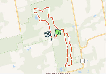
Tour Wandern von 9,6 km verfügbar auf Ontario, Dufferin County, Mono. Diese Tour wird von Alizée.pee vorgeschlagen.
Beschreibung
Sentier passant dans le parc pittoresque Mono Cliffs. Parfait pour les randonneurs de toutes habiletés malgré quelques endroits un peu plus techniques. Randonnée très agréable au niveau de ses paysages.
Ort
Land:
Canada
Region :
Ontario
Abteilung/Provinz :
Dufferin County
Kommune :
Mono
Standort:
Unknown
Gehen Sie:(Dec)
Gehen Sie:(UTM)
574127 ; 4876983 (17T) N.
Kommentare
Touren in der Umgebung
![Tour Wandern Mono - Wikiloc - Hockley Valley - Photo](https://media.geolcdn.com/t/375/260/ext.jpg?maxdim=2&url=https%3A%2F%2Fstatic1.geolcdn.com%2Fsiteimages%2Fupload%2Ffiles%2F1553511878bg_sport_marche.png)
![Wandern Wandern](https://static1.geolcdn.com/sitytour/trail-icons/101.png)
Wikiloc - Hockley Valley
Wandern
Schwierig
Mono,
Ontario,
Dufferin County,
Canada
![](/images/other/stat-length.png)
13,7 km | 18,5 km-effort
3h 56min
![](https://static1.geolcdn.com/siteimages/upload/files/16400158638029165_repeat_loop_refresh_sync_direction_icon.png)
Ja