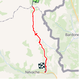
![](/images/other/stat-length.png)
![Tour Wandern Modane - RA 2019 Tour Mont Thabor J7 - Photo](https://media.geolcdn.com/t/1900/400/016b684e-800a-4b11-80d7-133494e5d907.jpg&format=pjpeg&maxdim=2)
RA 2019 Tour Mont Thabor J7
dfluzin
Benutzer
![Länge](/images/other/stat-length.png)
![Maximale Höhe](https://static1.geolcdn.com/siteimages/upload/files/1508320355ic_sort_altitude_max_24dp.png)
![Positive Höhendifferenz](https://static1.geolcdn.com/siteimages/upload/files/1508320355ic_sort_den_pos_24dp.png)
![Km-Effort](/images/other/stat-length.png)
![Min. Höhe](https://static1.geolcdn.com/siteimages/upload/files/1508320355ic_sort_altitude_min_24dp.png)
![Negative Höhendifferenz](https://static1.geolcdn.com/siteimages/upload/files/1508320355ic_sort_den_neg_24dp.png)
![Boucle](https://static1.geolcdn.com/siteimages/upload/files/16400158638029165_repeat_loop_refresh_sync_direction_icon.png)
![Wandern](https://static1.geolcdn.com/sitytour/trail-icons/101.png)
5h50
Schwierigkeit : Medium
![Scannen Sie diesen QR-Code, um die Tour in der SityTrail-Anwendung zu öffnen](https://capi.geolives.com/qq0zvz2zws4bq2lad0pu/sitytour/trails/2180336/qr.png?size=200)
Kostenlosegpshiking-Anwendung
Über SityTrail
Tour Wandern von 18,1 km verfügbar auf Auvergne-Rhone-Alpen, Savoyen, Modane. Diese Tour wird von dfluzin vorgeschlagen.
Beschreibung
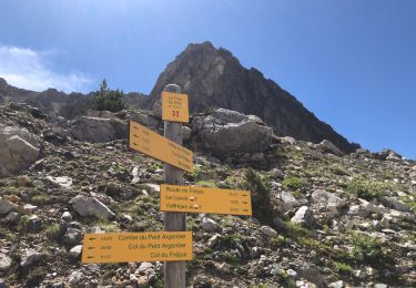
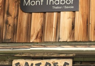
Nous terminons notre tour du Mont Thabor par la Vallée Etroite en descendant longuement du refuge du Mont Thabor. Puis une belle remontée bien tracée, nous fait traverser le très joli plateau des Thures, avant la plongée surprenante sur le hameau de Roubion où nous avions laissé le véhicule.
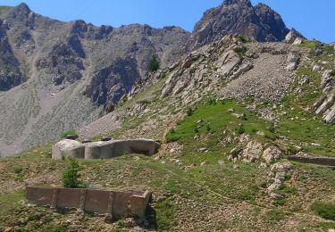
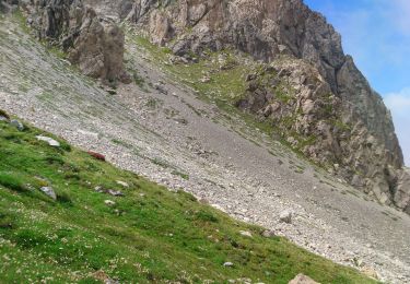
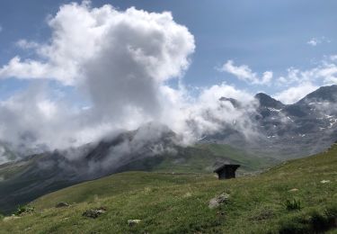
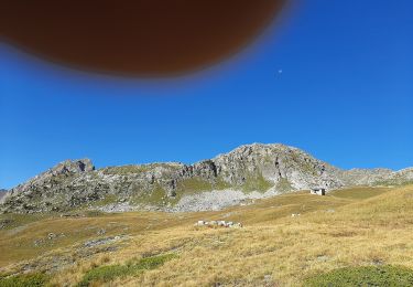
Belle journée, variée et la boucle par le Lago Verde est indispensable tant c'est beau voire incroyable
Ort
Kommentare
Touren in der Umgebung
![Tour Skiwanderen Modane - Le Grand Argentier - Photo](https://media.geolcdn.com/t/375/260/e21d4ca1-38c7-443d-8026-c36fbc8a0292.jpg&format=jpg&maxdim=2)
![Skiwanderen Skiwanderen](https://static1.geolcdn.com/sitytour/trail-icons/503.png)
Skiwanderen
![](/images/other/stat-length.png)
![](https://static1.geolcdn.com/siteimages/upload/files/16400158638029165_repeat_loop_refresh_sync_direction_icon.png)
![Tour Skiwanderen Modane - pointe des sarrasins - Photo](https://media.geolcdn.com/t/375/260/11a876bf-96a7-4155-9789-408cc9cbafaf.jpg&format=jpg&maxdim=2)
![Skiwanderen Skiwanderen](https://static1.geolcdn.com/sitytour/trail-icons/503.png)
Skiwanderen
![](/images/other/stat-length.png)
![](https://static1.geolcdn.com/siteimages/upload/files/16400158638029165_repeat_loop_refresh_sync_direction_icon.png)
![Tour Wandern Modane - mont Thabor - Photo](https://media.geolcdn.com/t/375/260/ext.jpg?maxdim=2&url=https%3A%2F%2Fstatic1.geolcdn.com%2Fsiteimages%2Fupload%2Ffiles%2F1553511878bg_sport_marche.png)
![Wandern Wandern](https://static1.geolcdn.com/sitytour/trail-icons/101.png)
Wandern
![](/images/other/stat-length.png)
![](https://static1.geolcdn.com/siteimages/upload/files/16400158638029165_repeat_loop_refresh_sync_direction_icon.png)
![Tour Wandern Modane - Télécabine Arrondaz Punta Bagna Lavoir Valfréjus - Photo](https://media.geolcdn.com/t/375/260/357497bc-6554-4d63-bbed-5431d02fde83.jpg&format=jpg&maxdim=2)
![Wandern Wandern](https://static1.geolcdn.com/sitytour/trail-icons/101.png)
Wandern
![](/images/other/stat-length.png)
![](https://static1.geolcdn.com/siteimages/upload/files/16400158638029165_repeat_loop_refresh_sync_direction_icon.png)
![Tour Wandern Modane - Arrondaz Col de Frejus - Photo](https://media.geolcdn.com/t/375/260/c8ad560a-8897-4009-ae1a-6ee679306148.jpg&format=jpg&maxdim=2)
![Wandern Wandern](https://static1.geolcdn.com/sitytour/trail-icons/101.png)
Wandern
![](/images/other/stat-length.png)
![](https://static1.geolcdn.com/siteimages/upload/files/16400158638029165_repeat_loop_refresh_sync_direction_icon.png)
![Tour Wandern Modane - Col Bataillères lac batailleres col des sarrazins - Photo](https://media.geolcdn.com/t/375/260/959dcff2-c80a-422e-9cae-d24f4fbb3454.jpg&format=jpg&maxdim=2)
![Wandern Wandern](https://static1.geolcdn.com/sitytour/trail-icons/101.png)
Wandern
![](/images/other/stat-length.png)
![](https://static1.geolcdn.com/siteimages/upload/files/16400158638029165_repeat_loop_refresh_sync_direction_icon.png)
![Tour Wandern Modane - Punta Néra ou le Grand Argentier VALFREJUS - Photo](https://media.geolcdn.com/t/375/260/da677389-00d9-46e9-82be-70588fdbf6ea.jpg&format=jpg&maxdim=2)
![Wandern Wandern](https://static1.geolcdn.com/sitytour/trail-icons/101.png)
Wandern
![](/images/other/stat-length.png)
![](https://static1.geolcdn.com/siteimages/upload/files/16400158638029165_repeat_loop_refresh_sync_direction_icon.png)
![Tour Wandern Modane - Refuge Thabor - Photo](https://media.geolcdn.com/t/375/260/961fd16a-6fcd-4f9c-9f3d-582d1dc0d095.jpg&format=jpg&maxdim=2)
![Wandern Wandern](https://static1.geolcdn.com/sitytour/trail-icons/101.png)
Wandern
![](/images/other/stat-length.png)
![](https://static1.geolcdn.com/siteimages/upload/files/16400158638029165_repeat_loop_refresh_sync_direction_icon.png)
![Tour Wandern Modane - col des sarrasins - Photo](https://media.geolcdn.com/t/375/260/70d138f9-e02b-4267-80bf-4d7e3c23ce07.jpg&format=jpg&maxdim=2)
![Wandern Wandern](https://static1.geolcdn.com/sitytour/trail-icons/101.png)
Wandern
![](/images/other/stat-length.png)
![](https://static1.geolcdn.com/siteimages/upload/files/16400158638029165_repeat_loop_refresh_sync_direction_icon.png)