![](/images/other/stat-length.png)
![Tour Wandern Beyssac - Moulin de Lignac - Photo](https://media.geolcdn.com/t/1900/400/ext.pjpeg?maxdim=2&url=https%3A%2F%2Fstatic1.geolcdn.com%2Fsiteimages%2Fupload%2Ffiles%2F1553511878bg_sport_marche.png)
Moulin de Lignac
houbart
Benutzer
![Länge](/images/other/stat-length.png)
Länge
6,9 km
![Maximale Höhe](https://static1.geolcdn.com/siteimages/upload/files/1508320355ic_sort_altitude_max_24dp.png)
Maximale Höhe
391 m
![Positive Höhendifferenz](https://static1.geolcdn.com/siteimages/upload/files/1508320355ic_sort_den_pos_24dp.png)
Positive Höhendifferenz
174 m
![Km-Effort](/images/other/stat-length.png)
Km-Effort
9,2 km
![Min. Höhe](https://static1.geolcdn.com/siteimages/upload/files/1508320355ic_sort_altitude_min_24dp.png)
Min. Höhe
312 m
![Negative Höhendifferenz](https://static1.geolcdn.com/siteimages/upload/files/1508320355ic_sort_den_neg_24dp.png)
Negative Höhendifferenz
174 m
![Boucle](https://static1.geolcdn.com/siteimages/upload/files/16400158638029165_repeat_loop_refresh_sync_direction_icon.png)
Boucle
Ja
Erstellungsdatum :
2019-08-20 11:58:33.873
Letzte Änderung :
2019-08-20 12:13:09.646
![Wandern](https://static1.geolcdn.com/sitytour/trail-icons/101.png)
1h58
Schwierigkeit : Medium
![Scannen Sie diesen QR-Code, um die Tour in der SityTrail-Anwendung zu öffnen](https://capi.geolives.com/qq0zvz2zws4bq2lad0pu/sitytour/trails/2177079/qr.png?size=200)
Kostenlosegpshiking-Anwendung
Über SityTrail
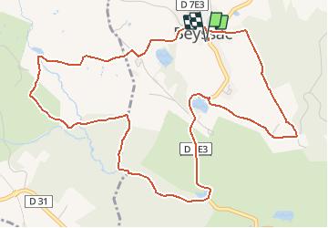
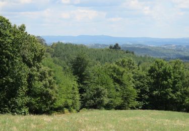
Tour Wandern von 6,9 km verfügbar auf Neu-Aquitanien, Corrèze, Beyssac. Diese Tour wird von houbart vorgeschlagen.
Beschreibung
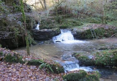
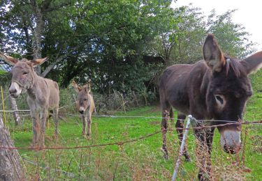
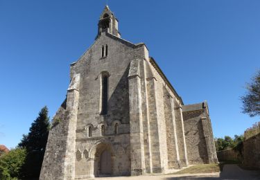
Départ de l'église construite par le pape Innocent VI au XIVe siècle. En chemin, le domaine de la Rivière, ancienne jumenterie du haras national. Une tour du château est recouverte de chaume.
Ort
Land:
France
Region :
Neu-Aquitanien
Abteilung/Provinz :
Corrèze
Kommune :
Beyssac
Standort:
Unknown
Gehen Sie:(Dec)
Gehen Sie:(UTM)
374974 ; 5025353 (31T) N.
Kommentare
Touren in der Umgebung
![Tour Wandern Lascaux - La Tine - Lascaux - Photo](https://media.geolcdn.com/t/375/260/ext.jpg?maxdim=2&url=https%3A%2F%2Fservices.sitytrail.com%2FGeolivesWS%2FDownloadMedia.ashx%3FTrailID%3D362600%26Media%3D175ef391-a279-4982-8858-a5aae8bf4699.JPG)
![Wandern Wandern](https://static1.geolcdn.com/sitytour/trail-icons/101.png)
La Tine - Lascaux
Wandern
Medium
(1)
Lascaux,
Neu-Aquitanien,
Corrèze,
France
![](/images/other/stat-length.png)
8,3 km | 11,9 km-effort
2h 35min
![](https://static1.geolcdn.com/siteimages/upload/files/16400158638029165_repeat_loop_refresh_sync_direction_icon.png)
Ja
![Tour Laufen Saint-Sornin-Lavolps - jour 21 CAP Jeanot - Photo](https://media.geolcdn.com/t/375/260/f7c090c8-dbf2-4cc9-9776-773b020c9b80.jpg&format=jpg&maxdim=2)
![Laufen Laufen](https://static1.geolcdn.com/sitytour/trail-icons/103.png)
jour 21 CAP Jeanot
Laufen
Sehr leicht
Saint-Sornin-Lavolps,
Neu-Aquitanien,
Corrèze,
France
![](/images/other/stat-length.png)
41 km | 52 km-effort
6h 24min
![](https://static1.geolcdn.com/siteimages/upload/files/16400158638029165_repeat_loop_refresh_sync_direction_icon.png)
Nein
![Tour Wandern Arnac-Pompadour - Arnac-Pompadour - Photo](https://media.geolcdn.com/t/375/260/ext.jpg?maxdim=2&url=https%3A%2F%2Fstatic1.geolcdn.com%2Fsiteimages%2Fupload%2Ffiles%2F1553511878bg_sport_marche.png)
![Wandern Wandern](https://static1.geolcdn.com/sitytour/trail-icons/101.png)
Arnac-Pompadour
Wandern
Sehr leicht
(2)
Arnac-Pompadour,
Neu-Aquitanien,
Corrèze,
France
![](/images/other/stat-length.png)
7,5 km | 9,2 km-effort
2h 2min
![](https://static1.geolcdn.com/siteimages/upload/files/16400158638029165_repeat_loop_refresh_sync_direction_icon.png)
Ja
![Wandern Wandern](https://static1.geolcdn.com/sitytour/trail-icons/101.png)
Le chemin des étangs au départ de Troche
Wandern
Medium
Troche,
Neu-Aquitanien,
Corrèze,
France
![](/images/other/stat-length.png)
7,2 km | 9,5 km-effort
1h 58min
![](https://static1.geolcdn.com/siteimages/upload/files/16400158638029165_repeat_loop_refresh_sync_direction_icon.png)
Ja
![Tour Zu Fuß Saint-Sornin-Lavolps - Forêt Domaniale de Pompadour par Saint-Sornin-Lavolps - Photo](https://media.geolcdn.com/t/375/260/c6da83a0-b5b9-48d8-93ed-723a43cc9f7c.jpg&format=jpg&maxdim=2)
![Zu Fuß Zu Fuß](https://static1.geolcdn.com/sitytour/trail-icons/100.png)
Forêt Domaniale de Pompadour par Saint-Sornin-Lavolps
Zu Fuß
Sehr leicht
Saint-Sornin-Lavolps,
Neu-Aquitanien,
Corrèze,
France
![](/images/other/stat-length.png)
8,6 km | 10,8 km-effort
Unbekannt
![](https://static1.geolcdn.com/siteimages/upload/files/16400158638029165_repeat_loop_refresh_sync_direction_icon.png)
Ja
![Tour Wandern Arnac-Pompadour - Arnac-Pompadour- Domaine de Chignac - Photo](https://media.geolcdn.com/t/375/260/ext.jpg?maxdim=2&url=https%3A%2F%2Fservices.sitytrail.com%2FGeolivesWS%2FDownloadMedia.ashx%3FTrailID%3D1049035%26Media%3D0c13fd81-6631-4747-8c52-1d414983a134.JPG)
![Wandern Wandern](https://static1.geolcdn.com/sitytour/trail-icons/101.png)
Arnac-Pompadour- Domaine de Chignac
Wandern
Einfach
Arnac-Pompadour,
Neu-Aquitanien,
Corrèze,
France
![](/images/other/stat-length.png)
6,2 km | 7,7 km-effort
1h 43min
![](https://static1.geolcdn.com/siteimages/upload/files/16400158638029165_repeat_loop_refresh_sync_direction_icon.png)
Ja
![Tour Wandern Beyssac - Beyssac (19230)- Chartreuse du Glandier et Canal des moines - Photo](https://media.geolcdn.com/t/375/260/ext.jpg?maxdim=2&url=https%3A%2F%2Fservices.sitytrail.com%2FGeolivesWS%2FDownloadMedia.ashx%3FTrailID%3D1049026%26Media%3D8558f252-1a38-414b-9a0d-e1468deabb1c.JPG)
![Wandern Wandern](https://static1.geolcdn.com/sitytour/trail-icons/101.png)
Beyssac (19230)- Chartreuse du Glandier et Canal des moines
Wandern
Sehr leicht
(1)
Beyssac,
Neu-Aquitanien,
Corrèze,
France
![](/images/other/stat-length.png)
4,6 km | 6,4 km-effort
1h 13min
![](https://static1.geolcdn.com/siteimages/upload/files/16400158638029165_repeat_loop_refresh_sync_direction_icon.png)
Ja
![Tour Wandern Concèze - Concèze- Les vignes - Photo](https://media.geolcdn.com/t/375/260/ext.jpg?maxdim=2&url=https%3A%2F%2Fservices.sitytrail.com%2FGeolivesWS%2FDownloadMedia.ashx%3FTrailID%3D597866%26Media%3Df04eb4b4-1613-4c9a-a004-cc15a78cc31f.JPG)
![Wandern Wandern](https://static1.geolcdn.com/sitytour/trail-icons/101.png)
Concèze- Les vignes
Wandern
Einfach
(1)
Concèze,
Neu-Aquitanien,
Corrèze,
France
![](/images/other/stat-length.png)
6,6 km | 8,8 km-effort
2h 6min
![](https://static1.geolcdn.com/siteimages/upload/files/16400158638029165_repeat_loop_refresh_sync_direction_icon.png)
Ja
![Tour Wandern Orgnac-sur-Vézère - orgnac sur Vézère - Photo](https://media.geolcdn.com/t/375/260/ext.jpg?maxdim=2&url=https%3A%2F%2Fstatic1.geolcdn.com%2Fsiteimages%2Fupload%2Ffiles%2F1553511878bg_sport_marche.png)
![Wandern Wandern](https://static1.geolcdn.com/sitytour/trail-icons/101.png)
orgnac sur Vézère
Wandern
Sehr schwierig
Orgnac-sur-Vézère,
Neu-Aquitanien,
Corrèze,
France
![](/images/other/stat-length.png)
22 km | 32 km-effort
7h 3min
![](https://static1.geolcdn.com/siteimages/upload/files/16400158638029165_repeat_loop_refresh_sync_direction_icon.png)
Ja