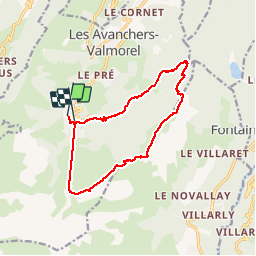
![](/images/other/stat-length.png)
![Tour Wandern Les Avanchers-Valmorel - Valmorel / Les bachals / Pierre Larron / Crève Tête - Photo](https://media.geolcdn.com/t/1900/400/2742fa80-09bc-473a-8383-42cb7225fa13.jpg&format=pjpeg&maxdim=2)
Valmorel / Les bachals / Pierre Larron / Crève Tête
zazie
Benutzer
![Länge](/images/other/stat-length.png)
![Maximale Höhe](https://static1.geolcdn.com/siteimages/upload/files/1508320355ic_sort_altitude_max_24dp.png)
![Positive Höhendifferenz](https://static1.geolcdn.com/siteimages/upload/files/1508320355ic_sort_den_pos_24dp.png)
![Km-Effort](/images/other/stat-length.png)
![Min. Höhe](https://static1.geolcdn.com/siteimages/upload/files/1508320355ic_sort_altitude_min_24dp.png)
![Negative Höhendifferenz](https://static1.geolcdn.com/siteimages/upload/files/1508320355ic_sort_den_neg_24dp.png)
![Boucle](https://static1.geolcdn.com/siteimages/upload/files/16400158638029165_repeat_loop_refresh_sync_direction_icon.png)
![Wandern](https://static1.geolcdn.com/sitytour/trail-icons/101.png)
3h58
Schwierigkeit : Schwierig
![Scannen Sie diesen QR-Code, um die Tour in der SityTrail-Anwendung zu öffnen](https://capi.geolives.com/qq0zvz2zws4bq2lad0pu/sitytour/trails/2157735/qr.png?size=200)
Kostenlosegpshiking-Anwendung
Über SityTrail
Tour Wandern von 13,5 km verfügbar auf Auvergne-Rhone-Alpen, Savoyen, Les Avanchers-Valmorel. Diese Tour wird von zazie vorgeschlagen.
Beschreibung
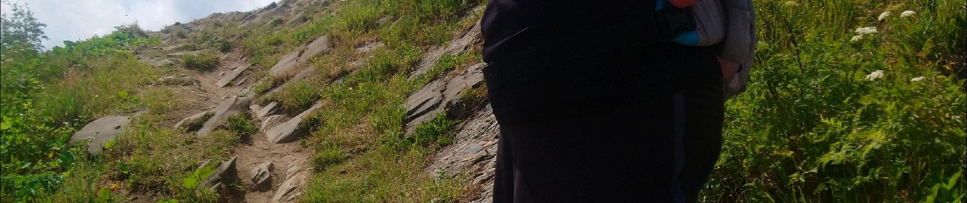
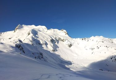
Randonnée toute en montée pour approcher Crève Tête par l'arrête sommitale. Redescente par le télécabine Pierrafort. Le sentier Crève Tête col du Gollet à été réaménagé avec des cordes dans les passages usés par le vent et les randonneurs.
Ort
Kommentare
Touren in der Umgebung
![Tour Wandern Les Belleville - Tour de Creve Tete - Photo](https://media.geolcdn.com/t/375/260/775f7fbd-61fe-4dac-aa88-5ad251aeb72f.jpg&format=jpg&maxdim=2)
![Wandern Wandern](https://static1.geolcdn.com/sitytour/trail-icons/101.png)
Wandern
![](/images/other/stat-length.png)
![](https://static1.geolcdn.com/siteimages/upload/files/16400158638029165_repeat_loop_refresh_sync_direction_icon.png)
![Tour Skiwanderen La Léchère - grand pic - Photo](https://media.geolcdn.com/t/375/260/9cfac439-c6a9-45dc-854a-66e0fdb870fb.jpg&format=jpg&maxdim=2)
![Skiwanderen Skiwanderen](https://static1.geolcdn.com/sitytour/trail-icons/503.png)
Skiwanderen
![](/images/other/stat-length.png)
![](https://static1.geolcdn.com/siteimages/upload/files/16400158638029165_repeat_loop_refresh_sync_direction_icon.png)
![Tour Skiwanderen La Léchère - Aiguille de la Balme - Photo](https://media.geolcdn.com/t/375/260/a3d2e41a-1caa-427e-9d80-b714bd5aac52.jpg&format=jpg&maxdim=2)
![Skiwanderen Skiwanderen](https://static1.geolcdn.com/sitytour/trail-icons/503.png)
Skiwanderen
![](/images/other/stat-length.png)
![](https://static1.geolcdn.com/siteimages/upload/files/16400158638029165_repeat_loop_refresh_sync_direction_icon.png)
![Tour Skiwanderen La Léchère - tricotage vers Les Teurs. - Photo](https://media.geolcdn.com/t/375/260/00642df7-11bb-44cc-a75b-471b0d819f21.jpg&format=jpg&maxdim=2)
![Skiwanderen Skiwanderen](https://static1.geolcdn.com/sitytour/trail-icons/503.png)
Skiwanderen
![](/images/other/stat-length.png)
![](https://static1.geolcdn.com/siteimages/upload/files/16400158638029165_repeat_loop_refresh_sync_direction_icon.png)
![Tour Skiwanderen La Léchère - Les marmottes noires - Photo](https://media.geolcdn.com/t/375/260/b231a722-c719-4ca9-8520-60ac6ec172da.jpg&format=jpg&maxdim=2)
![Skiwanderen Skiwanderen](https://static1.geolcdn.com/sitytour/trail-icons/503.png)
Skiwanderen
![](/images/other/stat-length.png)
![](https://static1.geolcdn.com/siteimages/upload/files/16400158638029165_repeat_loop_refresh_sync_direction_icon.png)
![Tour Skiwanderen La Léchère - le. chalet de Colomban - Photo](https://media.geolcdn.com/t/375/260/8594f6fb-22c5-4295-85ac-3463a33ec2ed.jpg&format=jpg&maxdim=2)
![Skiwanderen Skiwanderen](https://static1.geolcdn.com/sitytour/trail-icons/503.png)
Skiwanderen
![](/images/other/stat-length.png)
![](https://static1.geolcdn.com/siteimages/upload/files/16400158638029165_repeat_loop_refresh_sync_direction_icon.png)
![Tour Skiwanderen La Léchère - la pointe de la combe bronsin - Photo](https://media.geolcdn.com/t/375/260/15964385-eb75-4e54-ab69-efa3a84c15ec.jpg&format=jpg&maxdim=2)
![Skiwanderen Skiwanderen](https://static1.geolcdn.com/sitytour/trail-icons/503.png)
Skiwanderen
![](/images/other/stat-length.png)
![](https://static1.geolcdn.com/siteimages/upload/files/16400158638029165_repeat_loop_refresh_sync_direction_icon.png)
![Tour Skiwanderen La Léchère - Roche noire - Photo](https://media.geolcdn.com/t/375/260/9b9401f9-2d0c-481a-8b4d-bcf0642761c5.jpg&format=jpg&maxdim=2)
![Skiwanderen Skiwanderen](https://static1.geolcdn.com/sitytour/trail-icons/503.png)
Skiwanderen
![](/images/other/stat-length.png)
![](https://static1.geolcdn.com/siteimages/upload/files/16400158638029165_repeat_loop_refresh_sync_direction_icon.png)
![Tour Skiwanderen La Léchère - les portes de Montmélian - Photo](https://media.geolcdn.com/t/375/260/88246016-bae4-428f-a0ba-d11da7754eea.jpg&format=jpg&maxdim=2)
![Skiwanderen Skiwanderen](https://static1.geolcdn.com/sitytour/trail-icons/503.png)
Skiwanderen
![](/images/other/stat-length.png)
![](https://static1.geolcdn.com/siteimages/upload/files/16400158638029165_repeat_loop_refresh_sync_direction_icon.png)