![](/images/other/stat-length.png)
![Tour Mountainbike Deutsch-Oth - La frontière / Audun - Hussigny - Photo](https://media.geolcdn.com/t/1900/400/ext.pjpeg?maxdim=2&url=https%3A%2F%2Fstatic1.geolcdn.com%2Fsiteimages%2Fupload%2Ffiles%2F1524743154velo.jpg)
La frontière / Audun - Hussigny
Greg813
Benutzer
![Länge](/images/other/stat-length.png)
Länge
27 km
![Maximale Höhe](https://static1.geolcdn.com/siteimages/upload/files/1508320355ic_sort_altitude_max_24dp.png)
Maximale Höhe
437 m
![Positive Höhendifferenz](https://static1.geolcdn.com/siteimages/upload/files/1508320355ic_sort_den_pos_24dp.png)
Positive Höhendifferenz
437 m
![Km-Effort](/images/other/stat-length.png)
Km-Effort
33 km
![Min. Höhe](https://static1.geolcdn.com/siteimages/upload/files/1508320355ic_sort_altitude_min_24dp.png)
Min. Höhe
298 m
![Negative Höhendifferenz](https://static1.geolcdn.com/siteimages/upload/files/1508320355ic_sort_den_neg_24dp.png)
Negative Höhendifferenz
438 m
![Boucle](https://static1.geolcdn.com/siteimages/upload/files/16400158638029165_repeat_loop_refresh_sync_direction_icon.png)
Boucle
Ja
Erstellungsdatum :
2019-08-01 12:39:00.812
Letzte Änderung :
2019-08-02 08:48:53.044
![Mountainbike](https://static1.geolcdn.com/sitytour/trail-icons/202.png)
3h18
Schwierigkeit : Schwierig
![Scannen Sie diesen QR-Code, um die Tour in der SityTrail-Anwendung zu öffnen](https://capi.geolives.com/qq0zvz2zws4bq2lad0pu/sitytour/trails/2156709/qr.png?size=200)
Kostenlosegpshiking-Anwendung
Über SityTrail
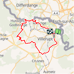
Tour Mountainbike von 27 km verfügbar auf Großer Osten, Mosel, Deutsch-Oth. Diese Tour wird von Greg813 vorgeschlagen.
Beschreibung
Randonné obligatoirement en VTT idéale pour faire travailler le cardio. En grande majorité ombragée, le passage le long des fortifications de la ligne Maginot vaut les efforts !
Ort
Land:
France
Region :
Großer Osten
Abteilung/Provinz :
Mosel
Kommune :
Deutsch-Oth
Standort:
Unknown
Gehen Sie:(Dec)
Gehen Sie:(UTM)
713978 ; 5483882 (31U) N.
Kommentare
Touren in der Umgebung
![Tour Zu Fuß Esch an der Alzette - Sentier Pierre Wiess - Photo](https://media.geolcdn.com/t/375/260/fb7503a0-8edc-4589-a05b-6ac952d1b3b6.jpeg&format=jpg&maxdim=2)
![Zu Fuß Zu Fuß](https://static1.geolcdn.com/sitytour/trail-icons/100.png)
Sentier Pierre Wiess
Zu Fuß
Einfach
Esch an der Alzette,
Unbekannt,
Kanton Esch an der Alzette,
Luxembourg
![](/images/other/stat-length.png)
3,9 km | 5,4 km-effort
1h 14min
![](https://static1.geolcdn.com/siteimages/upload/files/16400158638029165_repeat_loop_refresh_sync_direction_icon.png)
Nein
![Tour Zu Fuß Schifflingen - Auto-Pédestre Schifflange - Photo](https://media.geolcdn.com/t/375/260/6e4f4de8-0f99-4558-801f-ac0feb96d3b3.jpeg&format=jpg&maxdim=2)
![Zu Fuß Zu Fuß](https://static1.geolcdn.com/sitytour/trail-icons/100.png)
Auto-Pédestre Schifflange
Zu Fuß
Einfach
Schifflingen,
Unbekannt,
Kanton Esch an der Alzette,
Luxembourg
![](/images/other/stat-length.png)
7,8 km | 10,5 km-effort
2h 23min
![](https://static1.geolcdn.com/siteimages/upload/files/16400158638029165_repeat_loop_refresh_sync_direction_icon.png)
Ja
![Tour Zu Fuß Esch an der Alzette - Auto-Pédestre Esch-sur-Alzette - Photo](https://media.geolcdn.com/t/375/260/b5c02b78-1f2a-4286-8a45-2a22bbfe4d56.jpeg&format=jpg&maxdim=2)
![Zu Fuß Zu Fuß](https://static1.geolcdn.com/sitytour/trail-icons/100.png)
Auto-Pédestre Esch-sur-Alzette
Zu Fuß
Einfach
(1)
Esch an der Alzette,
Unbekannt,
Kanton Esch an der Alzette,
Luxembourg
![](/images/other/stat-length.png)
7,2 km | 9,8 km-effort
2h 13min
![](https://static1.geolcdn.com/siteimages/upload/files/16400158638029165_repeat_loop_refresh_sync_direction_icon.png)
Ja
![Tour Zu Fuß Kayl - Auto-Pédestre Kayl - Photo](https://media.geolcdn.com/t/375/260/05634cbd-69a7-4685-a005-dc48af1d3e5c.jpeg&format=jpg&maxdim=2)
![Zu Fuß Zu Fuß](https://static1.geolcdn.com/sitytour/trail-icons/100.png)
Auto-Pédestre Kayl
Zu Fuß
Einfach
Kayl,
Unbekannt,
Kanton Esch an der Alzette,
Luxembourg
![](/images/other/stat-length.png)
5,9 km | 7,6 km-effort
1h 43min
![](https://static1.geolcdn.com/siteimages/upload/files/16400158638029165_repeat_loop_refresh_sync_direction_icon.png)
Ja
![Tour Mountainbike Deutsch-Oth - la randodunoise 2010 - Photo](https://media.geolcdn.com/t/375/260/ext.jpg?maxdim=2&url=https%3A%2F%2Fstatic1.geolcdn.com%2Fsiteimages%2Fupload%2Ffiles%2F1524743154velo.jpg)
![Mountainbike Mountainbike](https://static1.geolcdn.com/sitytour/trail-icons/202.png)
la randodunoise 2010
Mountainbike
Sehr leicht
(1)
Deutsch-Oth,
Großer Osten,
Mosel,
France
![](/images/other/stat-length.png)
38 km | 48 km-effort
Unbekannt
![](https://static1.geolcdn.com/siteimages/upload/files/16400158638029165_repeat_loop_refresh_sync_direction_icon.png)
Nein
![Tour Zu Fuß Öttingen - Boucle d'Ottange - Photo](https://media.geolcdn.com/t/375/260/4f81de2e-9288-4ceb-9209-2e12554d6d66.jpeg&format=jpg&maxdim=2)
![Zu Fuß Zu Fuß](https://static1.geolcdn.com/sitytour/trail-icons/100.png)
Boucle d'Ottange
Zu Fuß
Einfach
Öttingen,
Großer Osten,
Mosel,
France
![](/images/other/stat-length.png)
4,1 km | 5,5 km-effort
1h 14min
![](https://static1.geolcdn.com/siteimages/upload/files/16400158638029165_repeat_loop_refresh_sync_direction_icon.png)
Ja
![Tour Zu Fuß Redingen - Boucle de Rédange - Photo](https://media.geolcdn.com/t/375/260/f050ebd0-ef73-4e7b-9c2b-78da25f4d2eb.jpeg&format=jpg&maxdim=2)
![Zu Fuß Zu Fuß](https://static1.geolcdn.com/sitytour/trail-icons/100.png)
Boucle de Rédange
Zu Fuß
Einfach
Redingen,
Großer Osten,
Mosel,
France
![](/images/other/stat-length.png)
4,6 km | 5,4 km-effort
1h 14min
![](https://static1.geolcdn.com/siteimages/upload/files/16400158638029165_repeat_loop_refresh_sync_direction_icon.png)
Nein
![Tour Zu Fuß Öttingen - Ottange Circuit Schmettebusch - Photo](https://media.geolcdn.com/t/375/260/e03ec25f-1ced-4014-8b11-d9cfd2f098ff.jpeg&format=jpg&maxdim=2)
![Zu Fuß Zu Fuß](https://static1.geolcdn.com/sitytour/trail-icons/100.png)
Ottange Circuit Schmettebusch
Zu Fuß
Einfach
Öttingen,
Großer Osten,
Mosel,
France
![](/images/other/stat-length.png)
5,7 km | 7,9 km-effort
1h 47min
![](https://static1.geolcdn.com/siteimages/upload/files/16400158638029165_repeat_loop_refresh_sync_direction_icon.png)
Nein
![Tour Zu Fuß Esch an der Alzette - Promenade Architecturale - Photo](https://media.geolcdn.com/t/375/260/fc1c5986-5145-4464-8347-1dd156f13990.jpeg&format=jpg&maxdim=2)
![Zu Fuß Zu Fuß](https://static1.geolcdn.com/sitytour/trail-icons/100.png)
Promenade Architecturale
Zu Fuß
Einfach
Esch an der Alzette,
Unbekannt,
Kanton Esch an der Alzette,
Luxembourg
![](/images/other/stat-length.png)
4 km | 4,3 km-effort
58min
![](https://static1.geolcdn.com/siteimages/upload/files/16400158638029165_repeat_loop_refresh_sync_direction_icon.png)
Ja