Tour Mountainbike Savines-le-Lac - circuits 25 et 11 mix. les eygoires, boscodon, le grand clot,  - Photo

circuits 25 et 11 mix. les eygoires, boscodon, le grand clot,

 guariso
guariso

Benutzer

© OpenStreetMap contributors
Länge
Länge
28 km
Maximale Höhe
Maximale Höhe
1683 m
Positive Höhendifferenz
1153 m
Km-Effort
Km-Effort  
43 km
Min. Höhe
Min. Höhe
785 m
Negative Höhendifferenz
1137 m
Boucle
Boucle
Ja
Erstellungsdatum :
2019-08-01 08:29:48.933
Letzte Änderung :
2019-08-01 13:52:35.406

(0 Nachricht)

Mountainbike
Mountainbike
4h06
Schwierigkeit : Schwierig

Scannen Sie diesen QR-Code, um die Tour in der SityTrail-Anwendung zu öffnen

Kostenlosegpshiking-Anwendung

Logo SityTrail SityTrail

IGN / Geografische Institute

SityTrail aus dem App Store herunterladen SityTrail von Google Play herunterladen

Logo SityTrail SityTrail World

Die Welt öffnet sich für Sie

SityTrail aus dem App Store herunterladen SityTrail von Google Play herunterladen SityTrail auf Huawei AppGallery herunterladen

Über SityTrail

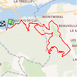
Tour Mountainbike von 28 km verfügbar auf Provence-Alpes-Côte d'Azur, Hochalpen, Savines-le-Lac. Diese Tour wird von guariso vorgeschlagen.

Beschreibung

boucle faisant un mix entre les circuits 25 et 11.
montées physiques mais sans difficulté. descentes très techniques en single.
durée en vtt normal, train pépère.

Höhenprofil

Ort

Land:
France
Region :
Provence-Alpes-Côte d'Azur
Abteilung/Provinz :
Hochalpen
Kommune :
Savines-le-Lac
Standort:
Unknown
Gehen Sie:(UTM)
292166 ; 4932802 (32T) N.

Touren in der Umgebung

Tour Wandern Crots - Le Cirque de Morgon - Photo
Wandern
tracegps

Wandern

Schwierig
(5)
Crots, Provence-Alpes-Côte d'Azur, Hochalpen, France
10,6 km | 21 km-effort
5h 30min
Ja
Tour Wandern Crots - Morgon par le Grand Clot - Photo
Wandern
GUIDE
David25400

Wandern

Einfach
(1)
Crots, Provence-Alpes-Côte d'Azur, Hochalpen, France
11,8 km | 22 km-effort
5h 49min
Ja
Tour Wandern Pontis - PONTIS , le dolmen  - Photo
Wandern
RobinMicheline

Wandern

Medium
(1)
Pontis, Provence-Alpes-Côte d'Azur, Alpes-de-Haute-Provence, France
12,9 km | 21 km-effort
3h 50min
Ja
Tour Wandern Puy-Saint-Eusèbe - canal de reyssas jusqu'aux Touisses / retour par le GR Serre-Ponçon via ravin de la pisse  - Photo
Wandern
GUIDE
stef789

Wandern

Medium
Puy-Saint-Eusèbe, Provence-Alpes-Côte d'Azur, Hochalpen, France
9,7 km | 15,4 km-effort
4h 51min
Ja
Tour Wandern Pontis - pic de Morgon par les ortals et les traverses  - Photo
Wandern
GUIDE
orsel

Wandern

Schwierig
Pontis, Provence-Alpes-Côte d'Azur, Alpes-de-Haute-Provence, France
12,3 km | 26 km-effort
8h 49min
Ja
Tour Wandern Pontis - Le Grand Morgon par la face nord 07/09/23 - Photo
Wandern
GUIDE
R@ph

Wandern

Schwierig
Pontis, Provence-Alpes-Côte d'Azur, Alpes-de-Haute-Provence, France
7,8 km | 18,9 km-effort
4h 18min
Ja
Tour Wandern Crots - Grand Morgon - Photo
Wandern
GUIDE
Marco05

Wandern

Medium
Crots, Provence-Alpes-Côte d'Azur, Hochalpen, France
11,4 km | 22 km-effort
4h 56min
Ja
Tour Wandern Crots - SityTrail - 2251353 - morgon-par-le-grand-clot - Photo
Wandern
GUIDE
amiral13

Wandern

Medium
Crots, Provence-Alpes-Côte d'Azur, Hochalpen, France
11,8 km | 22 km-effort
5h 30min
Ja
Tour Wandern Pontis - Morgon par les Traverses, retour par les Ortals - Photo
Wandern
GUIDE
David25400

Wandern

Sehr schwierig
Pontis, Provence-Alpes-Côte d'Azur, Alpes-de-Haute-Provence, France
17,1 km | 33 km-effort
5h 49min
Nein


Schließen
Meine Abonnements