![](/images/other/stat-length.png)
![Tour Rennrad Authume - Authume Samerey 20190723 - Photo](https://media.geolcdn.com/t/1900/400/ext.pjpeg?maxdim=2&url=https%3A%2F%2Fstatic1.geolcdn.com%2Fsiteimages%2Fupload%2Ffiles%2F1524743154velo.jpg)
Authume Samerey 20190723
cmike39
Benutzer
![Länge](/images/other/stat-length.png)
Länge
86 km
![Maximale Höhe](https://static1.geolcdn.com/siteimages/upload/files/1508320355ic_sort_altitude_max_24dp.png)
Maximale Höhe
370 m
![Positive Höhendifferenz](https://static1.geolcdn.com/siteimages/upload/files/1508320355ic_sort_den_pos_24dp.png)
Positive Höhendifferenz
759 m
![Km-Effort](/images/other/stat-length.png)
Km-Effort
96 km
![Min. Höhe](https://static1.geolcdn.com/siteimages/upload/files/1508320355ic_sort_altitude_min_24dp.png)
Min. Höhe
174 m
![Negative Höhendifferenz](https://static1.geolcdn.com/siteimages/upload/files/1508320355ic_sort_den_neg_24dp.png)
Negative Höhendifferenz
759 m
![Boucle](https://static1.geolcdn.com/siteimages/upload/files/16400158638029165_repeat_loop_refresh_sync_direction_icon.png)
Boucle
Ja
Erstellungsdatum :
2019-07-23 06:49:59.213
Letzte Änderung :
2019-07-28 14:05:37.347
![Rennrad](https://static1.geolcdn.com/sitytour/trail-icons/201.png)
3h18
Schwierigkeit : Sehr leicht
![Scannen Sie diesen QR-Code, um die Tour in der SityTrail-Anwendung zu öffnen](https://capi.geolives.com/qq0zvz2zws4bq2lad0pu/sitytour/trails/2152182/qr.png?size=200)
Kostenlosegpshiking-Anwendung
Über SityTrail
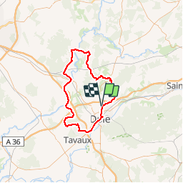
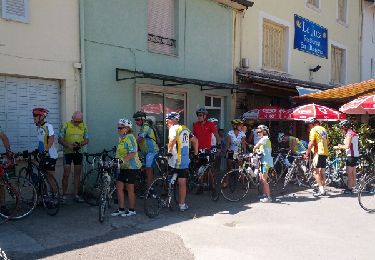
Tour Rennrad von 86 km verfügbar auf Burgund und Freigrafschaft, Jura, Authume. Diese Tour wird von cmike39 vorgeschlagen.
Beschreibung
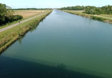
Eviter la section de véloroute Auxonne_Saint-Seine-en-Bâche qui comporte une partie non goudronnée. Préférer la route qui passe par Tillenay et Les Maillys pour rejoindre ST-Seine-En-Bâche.
Ort
Land:
France
Region :
Burgund und Freigrafschaft
Abteilung/Provinz :
Jura
Kommune :
Authume
Standort:
Unknown
Gehen Sie:(Dec)
Gehen Sie:(UTM)
689607 ; 5222193 (31T) N.
Kommentare
Touren in der Umgebung
![Tour Wandern Jouhe - Mont Roland 11.7km 20161215 - Photo](https://media.geolcdn.com/t/375/260/ext.jpg?maxdim=2&url=https%3A%2F%2Fstatic1.geolcdn.com%2Fsiteimages%2Fupload%2Ffiles%2F1553511878bg_sport_marche.png)
![Wandern Wandern](https://static1.geolcdn.com/sitytour/trail-icons/101.png)
Mont Roland 11.7km 20161215
Wandern
Sehr leicht
(1)
Jouhe,
Burgund und Freigrafschaft,
Jura,
France
![](/images/other/stat-length.png)
11,8 km | 15,4 km-effort
3h 18min
![](https://static1.geolcdn.com/siteimages/upload/files/16400158638029165_repeat_loop_refresh_sync_direction_icon.png)
Ja
![Tour Wandern Dole - Dole ville - Photo](https://media.geolcdn.com/t/375/260/ext.jpg?maxdim=2&url=https%3A%2F%2Fmedia.geolcdn.com%2Ff%2Fe28aad6a-c7e5-401c-94fb-452df6c86b47.jpg)
![Wandern Wandern](https://static1.geolcdn.com/sitytour/trail-icons/101.png)
Dole ville
Wandern
Dole,
Burgund und Freigrafschaft,
Jura,
France
![](/images/other/stat-length.png)
9,1 km | 10,6 km-effort
3h 2min
![](https://static1.geolcdn.com/siteimages/upload/files/16400158638029165_repeat_loop_refresh_sync_direction_icon.png)
Ja
![Tour Wandern Dole - Via Cluny: de Dole (Jura) à Cluny - Photo](https://media.geolcdn.com/t/375/260/ext.jpg?maxdim=2&url=https%3A%2F%2Fmedia.geolcdn.com%2Ff%2F1092a6f8-d0c7-4e5e-a178-164a2812cb66.jpg)
![Wandern Wandern](https://static1.geolcdn.com/sitytour/trail-icons/101.png)
Via Cluny: de Dole (Jura) à Cluny
Wandern
Sehr schwierig
Dole,
Burgund und Freigrafschaft,
Jura,
France
![](/images/other/stat-length.png)
360 km | 478 km-effort
108h 38min
![](https://static1.geolcdn.com/siteimages/upload/files/16400158638029165_repeat_loop_refresh_sync_direction_icon.png)
Nein
![Tour Rennrad Dole - mn05 - Photo](https://media.geolcdn.com/t/375/260/ext.jpg?maxdim=2&url=https%3A%2F%2Fmedia.geolcdn.com%2Ff%2F5ece753a-d519-46d1-b96a-31a274298d2e.jpg)
![Rennrad Rennrad](https://static1.geolcdn.com/sitytour/trail-icons/201.png)
mn05
Rennrad
Sehr schwierig
Dole,
Burgund und Freigrafschaft,
Jura,
France
![](/images/other/stat-length.png)
58 km | 63 km-effort
7h 44min
![](https://static1.geolcdn.com/siteimages/upload/files/16400158638029165_repeat_loop_refresh_sync_direction_icon.png)
Nein
![Tour Wandern Archelange - Archelange Mont Roland 2021-02-02 CAF - Photo](https://media.geolcdn.com/t/375/260/ext.jpg?maxdim=2&url=https%3A%2F%2Fmedia.geolcdn.com%2Ff%2F7a4e42ab-e89c-4e51-84b7-73e4641f6ef5.jpg)
![Wandern Wandern](https://static1.geolcdn.com/sitytour/trail-icons/101.png)
Archelange Mont Roland 2021-02-02 CAF
Wandern
Medium
Archelange,
Burgund und Freigrafschaft,
Jura,
France
![](/images/other/stat-length.png)
22 km | 28 km-effort
4h 23min
![](https://static1.geolcdn.com/siteimages/upload/files/16400158638029165_repeat_loop_refresh_sync_direction_icon.png)
Ja
![Tour Wandern Châtenois - R-Chatenois-20kil - Photo](https://media.geolcdn.com/t/375/260/ext.jpg?maxdim=2&url=https%3A%2F%2Fmedia.geolcdn.com%2Ff%2F30aa6a97-f70b-4c90-895e-1a66959b93ab.jpg)
![Wandern Wandern](https://static1.geolcdn.com/sitytour/trail-icons/101.png)
R-Chatenois-20kil
Wandern
Schwierig
(1)
Châtenois,
Burgund und Freigrafschaft,
Jura,
France
![](/images/other/stat-length.png)
20 km | 26 km-effort
5h 36min
![](https://static1.geolcdn.com/siteimages/upload/files/16400158638029165_repeat_loop_refresh_sync_direction_icon.png)
Ja
![Tour Wandern Amange - Malange 20171009 - Photo](https://media.geolcdn.com/t/375/260/ext.jpg?maxdim=2&url=https%3A%2F%2Fstatic1.geolcdn.com%2Fsiteimages%2Fupload%2Ffiles%2F1553511878bg_sport_marche.png)
![Wandern Wandern](https://static1.geolcdn.com/sitytour/trail-icons/101.png)
Malange 20171009
Wandern
Sehr leicht
(1)
Amange,
Burgund und Freigrafschaft,
Jura,
France
![](/images/other/stat-length.png)
10 km | 13,3 km-effort
2h 45min
![](https://static1.geolcdn.com/siteimages/upload/files/16400158638029165_repeat_loop_refresh_sync_direction_icon.png)
Ja
![Tour Wandern Jouhe - g)Etapa 7 - Photo](https://media.geolcdn.com/t/375/260/ext.jpg?maxdim=2&url=https%3A%2F%2Fservices.sitytrail.com%2FGeolivesWS%2FDownloadMedia.ashx%3FTrailID%3D711082%26Media%3D20170306151955.jpg)
![Wandern Wandern](https://static1.geolcdn.com/sitytour/trail-icons/101.png)
g)Etapa 7
Wandern
Einfach
Jouhe,
Burgund und Freigrafschaft,
Jura,
France
![](/images/other/stat-length.png)
26 km | 31 km-effort
2h 4min
![](https://static1.geolcdn.com/siteimages/upload/files/16400158638029165_repeat_loop_refresh_sync_direction_icon.png)
Nein
![Tour Fahrrad Dole - Bletterans - Photo](https://media.geolcdn.com/t/375/260/ext.jpg?maxdim=2&url=https%3A%2F%2Fservices.sitytrail.com%2FGeolivesWS%2FDownloadMedia.ashx%3FTrailID%3D466291%26Media%3Dfix__20150828142451.jpg)
![Fahrrad Fahrrad](https://static1.geolcdn.com/sitytour/trail-icons/200.png)
Bletterans
Fahrrad
Schwierig
Dole,
Burgund und Freigrafschaft,
Jura,
France
![](/images/other/stat-length.png)
125 km | 138 km-effort
6h 11min
![](https://static1.geolcdn.com/siteimages/upload/files/16400158638029165_repeat_loop_refresh_sync_direction_icon.png)
Ja