![](/images/other/stat-length.png)
![Tour Wandern Voyennes - La Courtemanche - Voyennes - Photo](https://media.geolcdn.com/t/1900/400/ext.pjpeg?maxdim=2&url=https%3A%2F%2Fservices.sitytrail.com%2FGeolivesWS%2FDownloadMedia.ashx%3FTrailID%3D215156%26Media%3D15751_2.jpg)
La Courtemanche - Voyennes
tracegps
Benutzer
![Länge](/images/other/stat-length.png)
Länge
10,1 km
![Maximale Höhe](https://static1.geolcdn.com/siteimages/upload/files/1508320355ic_sort_altitude_max_24dp.png)
Maximale Höhe
77 m
![Positive Höhendifferenz](https://static1.geolcdn.com/siteimages/upload/files/1508320355ic_sort_den_pos_24dp.png)
Positive Höhendifferenz
67 m
![Km-Effort](/images/other/stat-length.png)
Km-Effort
11 km
![Min. Höhe](https://static1.geolcdn.com/siteimages/upload/files/1508320355ic_sort_altitude_min_24dp.png)
Min. Höhe
54 m
![Negative Höhendifferenz](https://static1.geolcdn.com/siteimages/upload/files/1508320355ic_sort_den_neg_24dp.png)
Negative Höhendifferenz
66 m
![Boucle](https://static1.geolcdn.com/siteimages/upload/files/16400158638029165_repeat_loop_refresh_sync_direction_icon.png)
Boucle
Ja
Erstellungsdatum :
2014-12-10 00:00:00.0
Letzte Änderung :
2014-12-10 00:00:00.0
![Wandern](https://static1.geolcdn.com/sitytour/trail-icons/101.png)
2h40
Schwierigkeit : Medium
![Scannen Sie diesen QR-Code, um die Tour in der SityTrail-Anwendung zu öffnen](https://capi.geolives.com/qq0zvz2zws4bq2lad0pu/sitytour/trails/215156/qr.png?size=200)
Kostenlosegpshiking-Anwendung
Über SityTrail
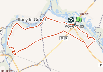
Tour Wandern von 10,1 km verfügbar auf Nordfrankreich, Somme, Voyennes. Diese Tour wird von tracegps vorgeschlagen.
Beschreibung
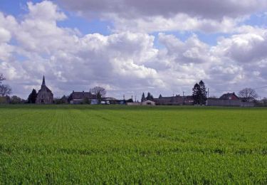
Départ de la place de Voyennes pour une balade entre Somme, canal du Nord, marais et plaines pour découvrir des paysages authentiques où l'Histoire n'est jamais bien loin. Téléchargez la fiche du circuit.
Ort
Land:
France
Region :
Nordfrankreich
Abteilung/Provinz :
Somme
Kommune :
Voyennes
Standort:
Unknown
Gehen Sie:(Dec)
Gehen Sie:(UTM)
498855 ; 5513331 (31U) N.
Kommentare
Touren in der Umgebung
![Tour Wandern Pargny - Circuit du clos Bouteille -Pargny - Photo](https://media.geolcdn.com/t/375/260/ext.jpg?maxdim=2&url=https%3A%2F%2Fservices.sitytrail.com%2FGeolivesWS%2FDownloadMedia.ashx%3FTrailID%3D1055081%26Media%3Dfix__20181011170913.jpg)
![Wandern Wandern](https://static1.geolcdn.com/sitytour/trail-icons/101.png)
Circuit du clos Bouteille -Pargny
Wandern
Einfach
Pargny,
Nordfrankreich,
Somme,
France
![](/images/other/stat-length.png)
11,5 km | 12,4 km-effort
2h 50min
![](https://static1.geolcdn.com/siteimages/upload/files/16400158638029165_repeat_loop_refresh_sync_direction_icon.png)
Ja
![Tour Wandern Sancourt - Source Magloire - Photo](https://media.geolcdn.com/t/375/260/6691ca2c-8822-424b-a40f-47067502ee53.jpg&format=jpg&maxdim=2)
![Wandern Wandern](https://static1.geolcdn.com/sitytour/trail-icons/101.png)
Source Magloire
Wandern
Medium
Sancourt,
Nordfrankreich,
Somme,
France
![](/images/other/stat-length.png)
14,2 km | 15,4 km-effort
3h 11min
![](https://static1.geolcdn.com/siteimages/upload/files/16400158638029165_repeat_loop_refresh_sync_direction_icon.png)
Nein
![Tour Wandern Pargny - Circuit du Clos Bouteille - Pargny - Photo](https://media.geolcdn.com/t/375/260/ext.jpg?maxdim=2&url=https%3A%2F%2Fservices.sitytrail.com%2FGeolivesWS%2FDownloadMedia.ashx%3FTrailID%3D110549%26Media%3D6106_2.jpg)
![Wandern Wandern](https://static1.geolcdn.com/sitytour/trail-icons/101.png)
Circuit du Clos Bouteille - Pargny
Wandern
Medium
Pargny,
Nordfrankreich,
Somme,
France
![](/images/other/stat-length.png)
10,7 km | 11,5 km-effort
2h 0min
![](https://static1.geolcdn.com/siteimages/upload/files/16400158638029165_repeat_loop_refresh_sync_direction_icon.png)
Ja
![Tour Wandern Pargny - Circuit du Fief Doré - Pargny - Photo](https://media.geolcdn.com/t/375/260/ext.jpg?maxdim=2&url=https%3A%2F%2Fservices.sitytrail.com%2FGeolivesWS%2FDownloadMedia.ashx%3FTrailID%3D110518%26Media%3D6062_2.jpg)
![Wandern Wandern](https://static1.geolcdn.com/sitytour/trail-icons/101.png)
Circuit du Fief Doré - Pargny
Wandern
Medium
Pargny,
Nordfrankreich,
Somme,
France
![](/images/other/stat-length.png)
10,7 km | 11,5 km-effort
2h 40min
![](https://static1.geolcdn.com/siteimages/upload/files/16400158638029165_repeat_loop_refresh_sync_direction_icon.png)
Ja
![Tour Wandern Voyennes - Circuit de la Courtemanche - Voyennes - Photo](https://media.geolcdn.com/t/375/260/ext.jpg?maxdim=2&url=https%3A%2F%2Fservices.sitytrail.com%2FGeolivesWS%2FDownloadMedia.ashx%3FTrailID%3D110492%26Media%3D6021_2.jpg)
![Wandern Wandern](https://static1.geolcdn.com/sitytour/trail-icons/101.png)
Circuit de la Courtemanche - Voyennes
Wandern
Medium
Voyennes,
Nordfrankreich,
Somme,
France
![](/images/other/stat-length.png)
11,9 km | 12,9 km-effort
3h 0min
![](https://static1.geolcdn.com/siteimages/upload/files/16400158638029165_repeat_loop_refresh_sync_direction_icon.png)
Ja
![Tour Wandern Nesle - Circuit de la fontaine Saint Quentin - Nesle - Photo](https://media.geolcdn.com/t/375/260/ext.jpg?maxdim=2&url=https%3A%2F%2Fservices.sitytrail.com%2FGeolivesWS%2FDownloadMedia.ashx%3FTrailID%3D110479%26Media%3D5995_1.jpg)
![Wandern Wandern](https://static1.geolcdn.com/sitytour/trail-icons/101.png)
Circuit de la fontaine Saint Quentin - Nesle
Wandern
Medium
Nesle,
Nordfrankreich,
Somme,
France
![](/images/other/stat-length.png)
12,5 km | 13,8 km-effort
3h 10min
![](https://static1.geolcdn.com/siteimages/upload/files/16400158638029165_repeat_loop_refresh_sync_direction_icon.png)
Ja
![Tour Wandern Hombleux - Circuit de la Croix Saint Claude - Hombleux - Photo](https://media.geolcdn.com/t/375/260/ext.jpg?maxdim=2&url=https%3A%2F%2Fservices.sitytrail.com%2FGeolivesWS%2FDownloadMedia.ashx%3FTrailID%3D110361%26Media%3D5822_1.jpg)
![Wandern Wandern](https://static1.geolcdn.com/sitytour/trail-icons/101.png)
Circuit de la Croix Saint Claude - Hombleux
Wandern
Schwierig
Hombleux,
Nordfrankreich,
Somme,
France
![](/images/other/stat-length.png)
15,7 km | 16,7 km-effort
4h 0min
![](https://static1.geolcdn.com/siteimages/upload/files/16400158638029165_repeat_loop_refresh_sync_direction_icon.png)
Ja
![Tour Wandern Sancourt - Source Magloire - Photo](https://media.geolcdn.com/t/375/260/ext.jpg?maxdim=2&url=https%3A%2F%2Fstatic1.geolcdn.com%2Fsiteimages%2Fupload%2Ffiles%2F1553511878bg_sport_marche.png)
![Wandern Wandern](https://static1.geolcdn.com/sitytour/trail-icons/101.png)
Source Magloire
Wandern
Schwierig
Sancourt,
Nordfrankreich,
Somme,
France
![](/images/other/stat-length.png)
12,8 km | 13,8 km-effort
3h 8min
![](https://static1.geolcdn.com/siteimages/upload/files/16400158638029165_repeat_loop_refresh_sync_direction_icon.png)
Ja
![Tour Wandern Pargny - le clos bouteille - Photo](https://media.geolcdn.com/t/375/260/ext.jpg?maxdim=2&url=https%3A%2F%2Fstatic1.geolcdn.com%2Fsiteimages%2Fupload%2Ffiles%2F1553511878bg_sport_marche.png)
![Wandern Wandern](https://static1.geolcdn.com/sitytour/trail-icons/101.png)
le clos bouteille
Wandern
Medium
Pargny,
Nordfrankreich,
Somme,
France
![](/images/other/stat-length.png)
9,5 km | 10,3 km-effort
2h 49min
![](https://static1.geolcdn.com/siteimages/upload/files/16400158638029165_repeat_loop_refresh_sync_direction_icon.png)
Ja
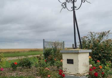
belle balade un peu difficile dur les chemins agricoles. un tres important dépôt de gravât modifie le chemin. veuillez apporter la correction merci