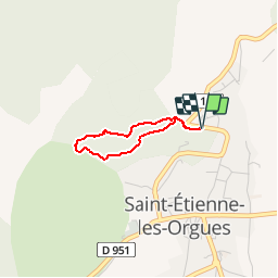
![](/images/other/stat-length.png)
![Tour Mountainbike Saint-Étienne-les-Orgues - Du Signal à Notre Dame de Lure - Photo](https://media.geolcdn.com/t/1900/400/ext.pjpeg?maxdim=2&url=https%3A%2F%2Fservices.sitytrail.com%2FGeolivesWS%2FDownloadMedia.ashx%3FTrailID%3D215038%26Media%3D15606_1.jpg)
Du Signal à Notre Dame de Lure
tracegps
Benutzer
![Länge](/images/other/stat-length.png)
![Maximale Höhe](https://static1.geolcdn.com/siteimages/upload/files/1508320355ic_sort_altitude_max_24dp.png)
![Positive Höhendifferenz](https://static1.geolcdn.com/siteimages/upload/files/1508320355ic_sort_den_pos_24dp.png)
![Km-Effort](/images/other/stat-length.png)
![Min. Höhe](https://static1.geolcdn.com/siteimages/upload/files/1508320355ic_sort_altitude_min_24dp.png)
![Negative Höhendifferenz](https://static1.geolcdn.com/siteimages/upload/files/1508320355ic_sort_den_neg_24dp.png)
![Boucle](https://static1.geolcdn.com/siteimages/upload/files/16400158638029165_repeat_loop_refresh_sync_direction_icon.png)
![Mountainbike](https://static1.geolcdn.com/sitytour/trail-icons/202.png)
3h00
Schwierigkeit : Schwierig
![Scannen Sie diesen QR-Code, um die Tour in der SityTrail-Anwendung zu öffnen](https://capi.geolives.com/qq0zvz2zws4bq2lad0pu/sitytour/trails/215038/qr.png?size=200)
Kostenlosegpshiking-Anwendung
Über SityTrail
Tour Mountainbike von 2 km verfügbar auf Provence-Alpes-Côte d'Azur, Alpes-de-Haute-Provence, Saint-Étienne-les-Orgues. Diese Tour wird von tracegps vorgeschlagen.
Beschreibung
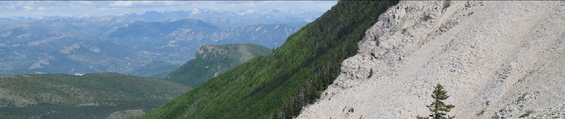
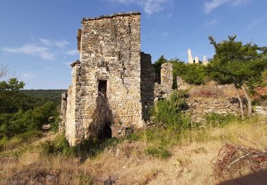
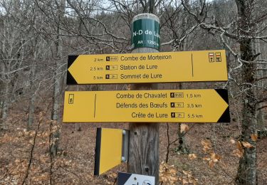
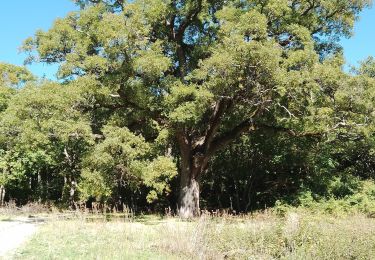
Sur les crêtes de Lure, le sol est recouvert d’innombrables pierres plates. De quoi rendre technique l'ascension jusqu'au sommet et pimenter la descente qui s'en suit ! Avant d'entrer dans les bois "feuillus" qui mènent à Notre Dame de Lure, la vue est aussi belle que la trace qui serpente entre les genévriers nains. Passé ce lieu de culte du XIIe siècle, les pistes forestières permettent de remonter progressivement jusqu'à la station. Si la neige recouvre une bonne partie du circuit l'hiver, l'altitude des lieux, entre Alpes et Provence, garantit une fraicheur salvatrice en période estivale. Adaptez votre vitesse à proximité de ND de Lure, le site est très fréquenté en été.
Ort
Kommentare
Touren in der Umgebung
![Tour Wandern Cruis - CRUIS . L ESPINASSE . DEFEND DES BOEUF . JAS ROCHE . O S L - Photo](https://media.geolcdn.com/t/375/260/a0cf8023-8ba0-4cae-8b97-e7a5d91b64cb.jpg&format=jpg&maxdim=2)
![Wandern Wandern](https://static1.geolcdn.com/sitytour/trail-icons/101.png)
Wandern
![](/images/other/stat-length.png)
![](https://static1.geolcdn.com/siteimages/upload/files/16400158638029165_repeat_loop_refresh_sync_direction_icon.png)
![Tour Wandern Saint-Étienne-les-Orgues - SAINT ETIENNE LES ORGUES . LE PONCHON DES CHOUX . 8 JAS O L - Photo](https://media.geolcdn.com/t/375/260/31b939da-7fe4-486b-a9fe-a6ccf57a27aa.jpg&format=jpg&maxdim=2)
![Wandern Wandern](https://static1.geolcdn.com/sitytour/trail-icons/101.png)
Wandern
![](/images/other/stat-length.png)
![](https://static1.geolcdn.com/siteimages/upload/files/16400158638029165_repeat_loop_refresh_sync_direction_icon.png)
![Tour Wandern Saint-Étienne-les-Orgues - SAINT ÉTIENNE LES ORGUES . Notre Dame de Lure o l - Photo](https://media.geolcdn.com/t/375/260/9aa33c84-db1e-42b2-a1b2-7401b4684bec.jpg&format=jpg&maxdim=2)
![Wandern Wandern](https://static1.geolcdn.com/sitytour/trail-icons/101.png)
Wandern
![](/images/other/stat-length.png)
![](https://static1.geolcdn.com/siteimages/upload/files/16400158638029165_repeat_loop_refresh_sync_direction_icon.png)
![Tour Wandern Saint-Étienne-les-Orgues - MONTLAUX. Le Revest. La Blache . Vieux Montlaux o l s - Photo](https://media.geolcdn.com/t/375/260/067d0493-31a9-484f-b222-caf0ca30ade9.jpg&format=jpg&maxdim=2)
![Wandern Wandern](https://static1.geolcdn.com/sitytour/trail-icons/101.png)
Wandern
![](/images/other/stat-length.png)
![](https://static1.geolcdn.com/siteimages/upload/files/16400158638029165_repeat_loop_refresh_sync_direction_icon.png)
![Tour Wandern Cruis - CRUIS . Jas Roche . Combe de Chevalet . ND de Lure o - Photo](https://media.geolcdn.com/t/375/260/f252a554-4783-452c-bf25-bee06d68bd1d.jpg&format=jpg&maxdim=2)
![Wandern Wandern](https://static1.geolcdn.com/sitytour/trail-icons/101.png)
Wandern
![](/images/other/stat-length.png)
![](https://static1.geolcdn.com/siteimages/upload/files/16400158638029165_repeat_loop_refresh_sync_direction_icon.png)
![Tour Wandern Saint-Étienne-les-Orgues - St Etienne les Orgues - La Blache - Photo](https://media.geolcdn.com/t/375/260/ext.jpg?maxdim=2&url=https%3A%2F%2Fstatic1.geolcdn.com%2Fsiteimages%2Fupload%2Ffiles%2F1553511878bg_sport_marche.png)
![Wandern Wandern](https://static1.geolcdn.com/sitytour/trail-icons/101.png)
Wandern
![](/images/other/stat-length.png)
![](https://static1.geolcdn.com/siteimages/upload/files/16400158638029165_repeat_loop_refresh_sync_direction_icon.png)
![Tour Wandern Lardiers - lardiers.le jas du grand chêne - Photo](https://media.geolcdn.com/t/375/260/a20a7e86-9075-402d-9419-9da41fb93e79.jpg&format=jpg&maxdim=2)
![Wandern Wandern](https://static1.geolcdn.com/sitytour/trail-icons/101.png)
Wandern
![](/images/other/stat-length.png)
![](https://static1.geolcdn.com/siteimages/upload/files/16400158638029165_repeat_loop_refresh_sync_direction_icon.png)
![Tour Wandern Lardiers - lardiers. du grand chêne à la bergerie inconnue - Photo](https://media.geolcdn.com/t/375/260/e56507b0-667f-45e8-a4de-a1d444c78beb.jpg&format=jpg&maxdim=2)
![Wandern Wandern](https://static1.geolcdn.com/sitytour/trail-icons/101.png)
Wandern
![](/images/other/stat-length.png)
![](https://static1.geolcdn.com/siteimages/upload/files/16400158638029165_repeat_loop_refresh_sync_direction_icon.png)
![Tour Wandern Montlaux - MONTLAUX. LES SOURCES DU LAUZON .O L M - Photo](https://media.geolcdn.com/t/375/260/f4854e53-edc8-45e8-9b45-a70e3872e836.jpg&format=jpg&maxdim=2)
![Wandern Wandern](https://static1.geolcdn.com/sitytour/trail-icons/101.png)
Wandern
![](/images/other/stat-length.png)
![](https://static1.geolcdn.com/siteimages/upload/files/16400158638029165_repeat_loop_refresh_sync_direction_icon.png)