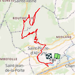
![](/images/other/stat-length.png)
![Tour Elektrofahrrad Saint-Pierre-d'Albigny - St Pierre d'Albigny - Col du Frêne - Routhennes- Chalet de l'épion - Photo](https://media.geolcdn.com/t/1900/400/ext.pjpeg?maxdim=2&url=https%3A%2F%2Fstatic1.geolcdn.com%2Fsiteimages%2Fupload%2Ffiles%2F1524743154velo.jpg)
St Pierre d'Albigny - Col du Frêne - Routhennes- Chalet de l'épion
marsupio
Benutzer
![Länge](/images/other/stat-length.png)
![Maximale Höhe](https://static1.geolcdn.com/siteimages/upload/files/1508320355ic_sort_altitude_max_24dp.png)
![Positive Höhendifferenz](https://static1.geolcdn.com/siteimages/upload/files/1508320355ic_sort_den_pos_24dp.png)
![Km-Effort](/images/other/stat-length.png)
![Min. Höhe](https://static1.geolcdn.com/siteimages/upload/files/1508320355ic_sort_altitude_min_24dp.png)
![Negative Höhendifferenz](https://static1.geolcdn.com/siteimages/upload/files/1508320355ic_sort_den_neg_24dp.png)
![Boucle](https://static1.geolcdn.com/siteimages/upload/files/16400158638029165_repeat_loop_refresh_sync_direction_icon.png)
![Elektrofahrrad](https://static1.geolcdn.com/sitytour/trail-icons/205.png)
4h04
Schwierigkeit : Schwierig
![Scannen Sie diesen QR-Code, um die Tour in der SityTrail-Anwendung zu öffnen](https://capi.geolives.com/qq0zvz2zws4bq2lad0pu/sitytour/trails/2148964/qr.png?size=200)
Kostenlosegpshiking-Anwendung
Über SityTrail
Tour Elektrofahrrad von 31 km verfügbar auf Auvergne-Rhone-Alpen, Savoyen, Saint-Pierre-d'Albigny. Diese Tour wird von marsupio vorgeschlagen.
Beschreibung
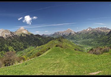
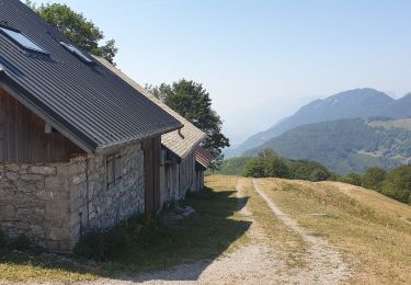
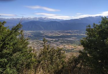
Essai d'un VTT électrique. De la route jusqu'à Routhennes puis chemin avec sur les derniers kilomètres des pentes extrêmes ne permettant plus l'adhérence de mes pneus typés bitume occasionnant la poussée du vélo de 24 kilos ! Mais la vue magnifique à 360° au chalet de l épion efface tous les doutes de l'utilité de cette montée. La descente du col du Frêne avec une pointe de vitesse à 64 km/h est génial.
Ort
Kommentare
Touren in der Umgebung
![Tour Wandern Saint-Pierre-d'Albigny - La Dent d'Arclusaz, 2041m - Photo](https://media.geolcdn.com/t/375/260/ext.jpg?maxdim=2&url=https%3A%2F%2Fservices.sitytrail.com%2FGeolivesWS%2FDownloadMedia.ashx%3FTrailID%3D105785%26Media%3D9678_1.jpg)
![Wandern Wandern](https://static1.geolcdn.com/sitytour/trail-icons/101.png)
Wandern
![](/images/other/stat-length.png)
![](https://static1.geolcdn.com/siteimages/upload/files/16400158638029165_repeat_loop_refresh_sync_direction_icon.png)
![Tour Wandern Sainte-Reine - Mont Pelat - Photo](https://media.geolcdn.com/t/375/260/7f0ecbf2-604f-4efc-a503-ee88b8b0b343.jpg&format=jpg&maxdim=2)
![Wandern Wandern](https://static1.geolcdn.com/sitytour/trail-icons/101.png)
Wandern
![](/images/other/stat-length.png)
![](https://static1.geolcdn.com/siteimages/upload/files/16400158638029165_repeat_loop_refresh_sync_direction_icon.png)
![Tour Wandern Sainte-Reine - Routhennes - col du potat - Photo](https://media.geolcdn.com/t/375/260/65fed8de-b503-4ecb-aa1d-a1896419183d.jpg&format=jpg&maxdim=2)
![Wandern Wandern](https://static1.geolcdn.com/sitytour/trail-icons/101.png)
Wandern
![](/images/other/stat-length.png)
![](https://static1.geolcdn.com/siteimages/upload/files/16400158638029165_repeat_loop_refresh_sync_direction_icon.png)
![Tour Rennrad Saint-Pierre-d'Albigny - saint pierre, Aiguebelle - Photo](https://media.geolcdn.com/t/375/260/076ea81b-7368-487e-8cf4-183d4150b7bf.jpg&format=jpg&maxdim=2)
![Rennrad Rennrad](https://static1.geolcdn.com/sitytour/trail-icons/201.png)
Rennrad
![](/images/other/stat-length.png)
![](https://static1.geolcdn.com/siteimages/upload/files/16400158638029165_repeat_loop_refresh_sync_direction_icon.png)
![Tour Wandern Saint-Pierre-d'Albigny - Pierre Besse vers la Croix d’Arclusaz - Photo](https://media.geolcdn.com/t/375/260/a9bf1cfa-4d9e-4376-acc8-5db58a8c6c0a.jpg&format=jpg&maxdim=2)
![Wandern Wandern](https://static1.geolcdn.com/sitytour/trail-icons/101.png)
Wandern
![](/images/other/stat-length.png)
![](https://static1.geolcdn.com/siteimages/upload/files/16400158638029165_repeat_loop_refresh_sync_direction_icon.png)
![Wandern Wandern](https://static1.geolcdn.com/sitytour/trail-icons/101.png)
Wandern
![](/images/other/stat-length.png)
![](https://static1.geolcdn.com/siteimages/upload/files/16400158638029165_repeat_loop_refresh_sync_direction_icon.png)
![Wandern Wandern](https://static1.geolcdn.com/sitytour/trail-icons/101.png)
Wandern
![](/images/other/stat-length.png)
![](https://static1.geolcdn.com/siteimages/upload/files/16400158638029165_repeat_loop_refresh_sync_direction_icon.png)
![Wandern Wandern](https://static1.geolcdn.com/sitytour/trail-icons/101.png)
Wandern
![](/images/other/stat-length.png)
![](https://static1.geolcdn.com/siteimages/upload/files/16400158638029165_repeat_loop_refresh_sync_direction_icon.png)
![Tour Wandern Saint-Pierre-d'Albigny - Odile rouge et bleu - Photo](https://media.geolcdn.com/t/375/260/9f28f7fa-4d4e-4148-b740-b2e8264be2cc.jpg&format=jpg&maxdim=2)
![Wandern Wandern](https://static1.geolcdn.com/sitytour/trail-icons/101.png)
Wandern
![](/images/other/stat-length.png)
![](https://static1.geolcdn.com/siteimages/upload/files/16400158638029165_repeat_loop_refresh_sync_direction_icon.png)