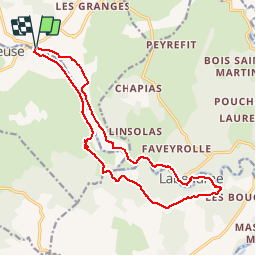
![](/images/other/stat-length.png)
![Tour Wandern Rosières - Les balcons de la Baume - Rosières - Photo](https://media.geolcdn.com/t/1900/400/ext.pjpeg?maxdim=2&url=https%3A%2F%2Fservices.sitytrail.com%2FGeolivesWS%2FDownloadMedia.ashx%3FTrailID%3D214839%26Media%3D15359_6.jpg)
Les balcons de la Baume - Rosières
tracegps
Benutzer
![Länge](/images/other/stat-length.png)
![Maximale Höhe](https://static1.geolcdn.com/siteimages/upload/files/1508320355ic_sort_altitude_max_24dp.png)
![Positive Höhendifferenz](https://static1.geolcdn.com/siteimages/upload/files/1508320355ic_sort_den_pos_24dp.png)
![Km-Effort](/images/other/stat-length.png)
![Min. Höhe](https://static1.geolcdn.com/siteimages/upload/files/1508320355ic_sort_altitude_min_24dp.png)
![Negative Höhendifferenz](https://static1.geolcdn.com/siteimages/upload/files/1508320355ic_sort_den_neg_24dp.png)
![Boucle](https://static1.geolcdn.com/siteimages/upload/files/16400158638029165_repeat_loop_refresh_sync_direction_icon.png)
![Wandern](https://static1.geolcdn.com/sitytour/trail-icons/101.png)
4h30
Schwierigkeit : Schwierig
![Scannen Sie diesen QR-Code, um die Tour in der SityTrail-Anwendung zu öffnen](https://capi.geolives.com/qq0zvz2zws4bq2lad0pu/sitytour/trails/214839/qr.png?size=200)
Kostenlosegpshiking-Anwendung
Über SityTrail
Tour Wandern von 17,2 km verfügbar auf Auvergne-Rhone-Alpen, Ardèche, Rosières. Diese Tour wird von tracegps vorgeschlagen.
Beschreibung
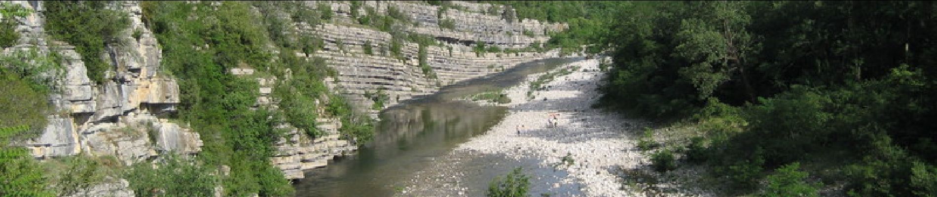
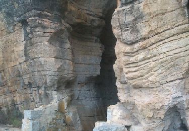
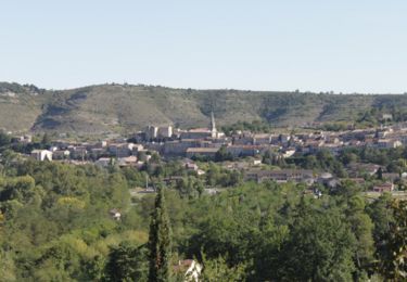
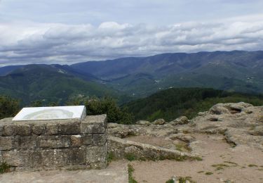
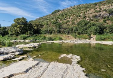
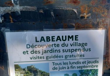
Splendide promenade au long de la rivière la Baume sur un sentier à flanc de falaise qui vous conduit au village classé de Labeaume. La visite s'impose du bas à partir du pont jusqu'en haut du village. Le circuit part en direction de Ruons et monte sur le plateau, rive droite. Retour sur une petite route et un grand sentier jusqu'à la sortie des gorges. Panorama splendide. On descend sur la rivière et on achève la boucle vers Rosières, on franchit la Baume dans un site remarquable. Le kilométrage peut être réduit en franchissant la rivière en aval de Rosières à condition que le niveau soit faible.
Ort
Kommentare
Touren in der Umgebung
![Tour Wandern Labeaume - Jardins suspendus de Labeaume - Photo](https://media.geolcdn.com/t/375/260/ext.jpg?maxdim=2&url=https%3A%2F%2Fservices.sitytrail.com%2FGeolivesWS%2FDownloadMedia.ashx%3FTrailID%3D339442%26Media%3Dfix__20140402152412.jpg)
![Wandern Wandern](https://static1.geolcdn.com/sitytour/trail-icons/101.png)
Wandern
![](/images/other/stat-length.png)
![](https://static1.geolcdn.com/siteimages/upload/files/16400158638029165_repeat_loop_refresh_sync_direction_icon.png)
![Tour Nordic Walking Labeaume - labeaume chapias - Photo](https://media.geolcdn.com/t/375/260/ext.jpg?maxdim=2&url=https%3A%2F%2Fstatic1.geolcdn.com%2Fsiteimages%2Fupload%2Ffiles%2F1545311037marcheuse_200dpi.jpg)
![Nordic Walking Nordic Walking](https://static1.geolcdn.com/sitytour/trail-icons/102.png)
Nordic Walking
![](/images/other/stat-length.png)
![](https://static1.geolcdn.com/siteimages/upload/files/16400158638029165_repeat_loop_refresh_sync_direction_icon.png)
![Tour Wandern Joyeuse - Le balcon du Freyssinet - Joyeuse - Photo](https://media.geolcdn.com/t/375/260/ext.jpg?maxdim=2&url=https%3A%2F%2Fservices.sitytrail.com%2FGeolivesWS%2FDownloadMedia.ashx%3FTrailID%3D191628%26Media%3D15269_1.jpg)
![Wandern Wandern](https://static1.geolcdn.com/sitytour/trail-icons/101.png)
Wandern
![](/images/other/stat-length.png)
![](https://static1.geolcdn.com/siteimages/upload/files/16400158638029165_repeat_loop_refresh_sync_direction_icon.png)
![Tour Wandern Vernon - Vernon Tour de Brison 20km - Photo](https://media.geolcdn.com/t/375/260/1d443c17-2f68-4a33-bd33-d422959f5b68.jpg&format=jpg&maxdim=2)
![Wandern Wandern](https://static1.geolcdn.com/sitytour/trail-icons/101.png)
Wandern
![](/images/other/stat-length.png)
![](https://static1.geolcdn.com/siteimages/upload/files/16400158638029165_repeat_loop_refresh_sync_direction_icon.png)
![Tour Wandern Labeaume - Labaume - Photo](https://media.geolcdn.com/t/375/260/100f777b-ca43-4f22-8315-f8e51f0fe1ef.jpg&format=jpg&maxdim=2)
![Wandern Wandern](https://static1.geolcdn.com/sitytour/trail-icons/101.png)
Wandern
![](/images/other/stat-length.png)
![](https://static1.geolcdn.com/siteimages/upload/files/16400158638029165_repeat_loop_refresh_sync_direction_icon.png)
![Tour Wandern Vernon - 07 Vernon 25 02 2021 - Photo](https://media.geolcdn.com/t/375/260/bf74ca26-a5ee-4a75-afb9-c1a8b51eb415.jpg&format=jpg&maxdim=2)
![Wandern Wandern](https://static1.geolcdn.com/sitytour/trail-icons/101.png)
Wandern
![](/images/other/stat-length.png)
![](https://static1.geolcdn.com/siteimages/upload/files/16400158638029165_repeat_loop_refresh_sync_direction_icon.png)
![Tour Wandern Labeaume - Chapias - Photo](https://media.geolcdn.com/t/375/260/ext.jpg?maxdim=2&url=https%3A%2F%2Fstatic1.geolcdn.com%2Fsiteimages%2Fupload%2Ffiles%2F1553511878bg_sport_marche.png)
![Wandern Wandern](https://static1.geolcdn.com/sitytour/trail-icons/101.png)
Wandern
![](/images/other/stat-length.png)
![](https://static1.geolcdn.com/siteimages/upload/files/16400158638029165_repeat_loop_refresh_sync_direction_icon.png)
![Tour Laufen Rosières - 13km - Photo](https://media.geolcdn.com/t/375/260/61681b10-36d4-4fbe-858a-0651fc8e085a.jpg&format=jpg&maxdim=2)
![Laufen Laufen](https://static1.geolcdn.com/sitytour/trail-icons/103.png)
Laufen
![](/images/other/stat-length.png)
![](https://static1.geolcdn.com/siteimages/upload/files/16400158638029165_repeat_loop_refresh_sync_direction_icon.png)
![Tour Wandern Labeaume - ARDECHE. LA BAUME. GORGES DE LA BAUME. LEBAUME.DOLMENS OE - Photo](https://media.geolcdn.com/t/375/260/7366c34a-b7d9-48a0-ae49-28be0ea93c3a.jpg&format=jpg&maxdim=2)
![Wandern Wandern](https://static1.geolcdn.com/sitytour/trail-icons/101.png)
Wandern
![](/images/other/stat-length.png)
![](https://static1.geolcdn.com/siteimages/upload/files/16400158638029165_repeat_loop_refresh_sync_direction_icon.png)
parcour a revoir chemin prive 7 km
Soucis à 7km apres les campings un chemin privé clôture en haut de la côte pas pu continue .
passage bord de rivière après camping les platanes fermé, propriété prive