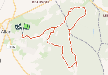
![](/images/other/stat-length.png)
![Tour Nordic Walking Allan - 26-Allan-La Motte-Croix de Siméon - Photo](https://media.geolcdn.com/t/1900/400/2ee9712a-b029-452d-998a-d9b450e66bae.jpg&format=pjpeg&maxdim=2)
26-Allan-La Motte-Croix de Siméon
Maryma
Benutzer
![Länge](/images/other/stat-length.png)
![Maximale Höhe](https://static1.geolcdn.com/siteimages/upload/files/1508320355ic_sort_altitude_max_24dp.png)
![Positive Höhendifferenz](https://static1.geolcdn.com/siteimages/upload/files/1508320355ic_sort_den_pos_24dp.png)
![Km-Effort](/images/other/stat-length.png)
![Min. Höhe](https://static1.geolcdn.com/siteimages/upload/files/1508320355ic_sort_altitude_min_24dp.png)
![Negative Höhendifferenz](https://static1.geolcdn.com/siteimages/upload/files/1508320355ic_sort_den_neg_24dp.png)
![Boucle](https://static1.geolcdn.com/siteimages/upload/files/16400158638029165_repeat_loop_refresh_sync_direction_icon.png)
![Nordic Walking](https://static1.geolcdn.com/sitytour/trail-icons/102.png)
2h42
Schwierigkeit : Einfach
![Scannen Sie diesen QR-Code, um die Tour in der SityTrail-Anwendung zu öffnen](https://capi.geolives.com/qq0zvz2zws4bq2lad0pu/sitytour/trails/2140863/qr.png?size=200)
Kostenlosegpshiking-Anwendung
Über SityTrail
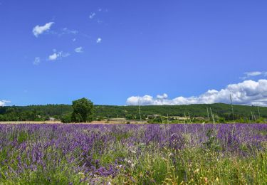
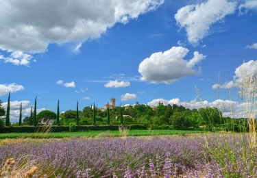
Tour Nordic Walking von 13,1 km verfügbar auf Auvergne-Rhone-Alpen, Drôme, Allan. Diese Tour wird von Maryma vorgeschlagen.
Beschreibung
la difficulté réside surtout dans des passages avec de gros cailloux.
A la fontaine d'Artur, faites une boucle NE en passant par le point altimétrique 225 pour revenir sur le chemin. Ce qui sera moins raide avec un sentier plus propice à la marche.
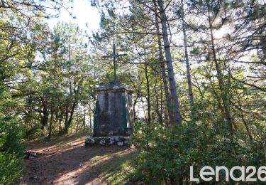
Au mémorial, éviter l'aller retour. Fausse route.
En fin de parcours, on peut écourter en passant par une petite route. J'ai fait le choix d'un sentier ombragé.
Sur le temps de parcours vous gagnerez facilement 20 mn car j'ai marqué plusieurs arrêts pour m'orienter.
Ort
Kommentare
Touren in der Umgebung
![Tour Wandern Espeluche - 2022-10-20_15h14m37_GPX-Bois-Jamot-Espeluche - Photo](https://media.geolcdn.com/t/375/260/799cda92-0993-44e5-bfc9-d42f9f871bf2.jpg&format=jpg&maxdim=2)
![Wandern Wandern](https://static1.geolcdn.com/sitytour/trail-icons/101.png)
Wandern
![](/images/other/stat-length.png)
![](https://static1.geolcdn.com/siteimages/upload/files/16400158638029165_repeat_loop_refresh_sync_direction_icon.png)
![Tour Wandern Rochefort-en-Valdaine - Rochefort-en-Valdaine Le Janeston 7km5 - Photo](https://media.geolcdn.com/t/375/260/c37954dd-2a13-465c-a79c-9622f5a3d882.jpg&format=jpg&maxdim=2)
![Wandern Wandern](https://static1.geolcdn.com/sitytour/trail-icons/101.png)
Wandern
![](/images/other/stat-length.png)
![](https://static1.geolcdn.com/siteimages/upload/files/16400158638029165_repeat_loop_refresh_sync_direction_icon.png)
![Tour Wandern Allan - allan transclavienne rac - Photo](https://media.geolcdn.com/t/375/260/ext.jpg?maxdim=2&url=https%3A%2F%2Fservices.sitytrail.com%2FGeolivesWS%2FDownloadMedia.ashx%3FTrailID%3D649381%26Media%3Dfix__20161022171755.jpg)
![Wandern Wandern](https://static1.geolcdn.com/sitytour/trail-icons/101.png)
Wandern
![](/images/other/stat-length.png)
![](https://static1.geolcdn.com/siteimages/upload/files/16400158638029165_repeat_loop_refresh_sync_direction_icon.png)
![Tour Mountainbike Puygiron - Puygiron VTT n°5 - Photo](https://media.geolcdn.com/t/375/260/ext.jpg?maxdim=2&url=https%3A%2F%2Fservices.sitytrail.com%2FGeolivesWS%2FDownloadMedia.ashx%3FTrailID%3D104845%26Media%3D8346_2.jpg)
![Mountainbike Mountainbike](https://static1.geolcdn.com/sitytour/trail-icons/202.png)
Mountainbike
![](/images/other/stat-length.png)
![](https://static1.geolcdn.com/siteimages/upload/files/16400158638029165_repeat_loop_refresh_sync_direction_icon.png)
![Wandern Wandern](https://static1.geolcdn.com/sitytour/trail-icons/101.png)
Wandern
![](/images/other/stat-length.png)
![](https://static1.geolcdn.com/siteimages/upload/files/16400158638029165_repeat_loop_refresh_sync_direction_icon.png)
![Tour Wandern Espeluche - 2022-10-10_11h19m57_9875258 - Photo](https://media.geolcdn.com/t/375/260/7d9cd8c2-7377-40ec-9100-181655b047cd.jpg&format=jpg&maxdim=2)
![Wandern Wandern](https://static1.geolcdn.com/sitytour/trail-icons/101.png)
Wandern
![](/images/other/stat-length.png)
![](https://static1.geolcdn.com/siteimages/upload/files/16400158638029165_repeat_loop_refresh_sync_direction_icon.png)
![Tour Wandern Puygiron - 2022-10-01_17h29m30_13056647 - Photo](https://media.geolcdn.com/t/375/260/0d0cf363-5e9d-4b75-83e8-04f87bc5f99f.jpg&format=jpg&maxdim=2)
![Wandern Wandern](https://static1.geolcdn.com/sitytour/trail-icons/101.png)
Wandern
![](/images/other/stat-length.png)
![](https://static1.geolcdn.com/siteimages/upload/files/16400158638029165_repeat_loop_refresh_sync_direction_icon.png)
![Tour sport Allan - SityTrail - Les Villages Perchés. - Photo](https://media.geolcdn.com/t/375/260/ext.jpg?maxdim=2&url=https%3A%2F%2Fsecurestorage.geolives.com%2Fsitytour%2Ftrail-bg%2Fdefault.jpg)
sport
![](/images/other/stat-length.png)
![](https://static1.geolcdn.com/siteimages/upload/files/16400158638029165_repeat_loop_refresh_sync_direction_icon.png)
![Tour Wandern Puygiron - 26 Puygiron au coucher du soleil - Photo](https://media.geolcdn.com/t/375/260/6a9076b3-c7c1-45d1-b229-976a2c31befe.jpg&format=jpg&maxdim=2)
![Wandern Wandern](https://static1.geolcdn.com/sitytour/trail-icons/101.png)
Wandern
![](/images/other/stat-length.png)
![](https://static1.geolcdn.com/siteimages/upload/files/16400158638029165_repeat_loop_refresh_sync_direction_icon.png)