![](/images/other/stat-length.png)
![Tour Wandern Thônes - beauregard depuis Thônes - Photo](https://media.geolcdn.com/t/1900/400/ext.pjpeg?maxdim=2&url=https%3A%2F%2Fstatic1.geolcdn.com%2Fsiteimages%2Fupload%2Ffiles%2F1553511878bg_sport_marche.png)
beauregard depuis Thônes
woodywoodfucker
Benutzer
![Länge](/images/other/stat-length.png)
Länge
21 km
![Maximale Höhe](https://static1.geolcdn.com/siteimages/upload/files/1508320355ic_sort_altitude_max_24dp.png)
Maximale Höhe
1692 m
![Positive Höhendifferenz](https://static1.geolcdn.com/siteimages/upload/files/1508320355ic_sort_den_pos_24dp.png)
Positive Höhendifferenz
1326 m
![Km-Effort](/images/other/stat-length.png)
Km-Effort
38 km
![Min. Höhe](https://static1.geolcdn.com/siteimages/upload/files/1508320355ic_sort_altitude_min_24dp.png)
Min. Höhe
627 m
![Negative Höhendifferenz](https://static1.geolcdn.com/siteimages/upload/files/1508320355ic_sort_den_neg_24dp.png)
Negative Höhendifferenz
1359 m
![Boucle](https://static1.geolcdn.com/siteimages/upload/files/16400158638029165_repeat_loop_refresh_sync_direction_icon.png)
Boucle
Nein
Erstellungsdatum :
2019-07-07 11:30:46.642
Letzte Änderung :
2019-07-07 15:46:08.095
![Wandern](https://static1.geolcdn.com/sitytour/trail-icons/101.png)
4h09
Schwierigkeit : Schwierig
![Scannen Sie diesen QR-Code, um die Tour in der SityTrail-Anwendung zu öffnen](https://capi.geolives.com/qq0zvz2zws4bq2lad0pu/sitytour/trails/2133551/qr.png?size=200)
Kostenlosegpshiking-Anwendung
Über SityTrail
Tour Wandern von 21 km verfügbar auf Auvergne-Rhone-Alpen, Hochsavoyen, Thônes. Diese Tour wird von woodywoodfucker vorgeschlagen.
Beschreibung
départ de Thônes par la forêt du mont, puis ascension vers beauregard en passantpar la closette et la ferme des Vonezins
retour par les fretes et le petit novard
Ort
Land:
France
Region :
Auvergne-Rhone-Alpen
Abteilung/Provinz :
Hochsavoyen
Kommune :
Thônes
Standort:
Unknown
Gehen Sie:(Dec)
Gehen Sie:(UTM)
292849 ; 5084429 (32T) N.
Kommentare
Touren in der Umgebung
![Tour Skiwanderen Les Clefs - Col sud de la Tournette - Photo](https://media.geolcdn.com/t/375/260/74646cbc-70a2-47cf-b394-1c46ccebcdcc.jpg&format=jpg&maxdim=2)
![Skiwanderen Skiwanderen](https://static1.geolcdn.com/sitytour/trail-icons/503.png)
Col sud de la Tournette
Skiwanderen
Medium
Les Clefs,
Auvergne-Rhone-Alpen,
Hochsavoyen,
France
![](/images/other/stat-length.png)
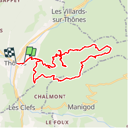
10,7 km | 28 km-effort
5h 4min
![](https://static1.geolcdn.com/siteimages/upload/files/16400158638029165_repeat_loop_refresh_sync_direction_icon.png)
Ja
![Tour Wandern Thônes - Mont Lachat - Le Belvédère par grotte de Barmafi - Photo](https://media.geolcdn.com/t/375/260/298060c0-07df-4e4f-8f7a-96333462f81e.jpg&format=jpg&maxdim=2)
![Wandern Wandern](https://static1.geolcdn.com/sitytour/trail-icons/101.png)
Mont Lachat - Le Belvédère par grotte de Barmafi
Wandern
Medium
Thônes,
Auvergne-Rhone-Alpen,
Hochsavoyen,
France
![](/images/other/stat-length.png)
9,5 km | 21 km-effort
3h 57min
![](https://static1.geolcdn.com/siteimages/upload/files/16400158638029165_repeat_loop_refresh_sync_direction_icon.png)
Ja
![Tour Wandern Thônes - Tour Montagne des Auges par Tetaz et Buffaz - Photo](https://media.geolcdn.com/t/375/260/ext.jpg?maxdim=2&url=https%3A%2F%2Fservices.sitytrail.com%2FGeolivesWS%2FDownloadMedia.ashx%3FTrailID%3D988169%26Media%3Dfix__20180617140819.jpg)
![Wandern Wandern](https://static1.geolcdn.com/sitytour/trail-icons/101.png)
Tour Montagne des Auges par Tetaz et Buffaz
Wandern
Medium
Thônes,
Auvergne-Rhone-Alpen,
Hochsavoyen,
France
![](/images/other/stat-length.png)
19,1 km | 33 km-effort
5h 45min
![](https://static1.geolcdn.com/siteimages/upload/files/16400158638029165_repeat_loop_refresh_sync_direction_icon.png)
Ja
![Tour Schneeschuhwandern Thônes - Mlande Platenet Frassot Mlande - Photo](https://media.geolcdn.com/t/375/260/ext.jpg?maxdim=2&url=https%3A%2F%2Fstatic1.geolcdn.com%2Fsiteimages%2Fupload%2Ffiles%2F1524743153raquette.jpg)
![Schneeschuhwandern Schneeschuhwandern](https://static1.geolcdn.com/sitytour/trail-icons/504.png)
Mlande Platenet Frassot Mlande
Schneeschuhwandern
Sehr leicht
(1)
Thônes,
Auvergne-Rhone-Alpen,
Hochsavoyen,
France
![](/images/other/stat-length.png)
7,3 km | 13,7 km-effort
3h 24min
![](https://static1.geolcdn.com/siteimages/upload/files/16400158638029165_repeat_loop_refresh_sync_direction_icon.png)
Ja
![Tour Wandern Thônes - Col de l'ovine - Photo](https://media.geolcdn.com/t/375/260/ext.jpg?maxdim=2&url=https%3A%2F%2Fstatic1.geolcdn.com%2Fsiteimages%2Fupload%2Ffiles%2F1553511878bg_sport_marche.png)
![Wandern Wandern](https://static1.geolcdn.com/sitytour/trail-icons/101.png)
Col de l'ovine
Wandern
Medium
(1)
Thônes,
Auvergne-Rhone-Alpen,
Hochsavoyen,
France
![](/images/other/stat-length.png)
15,8 km | 29 km-effort
6h 0min
![](https://static1.geolcdn.com/siteimages/upload/files/16400158638029165_repeat_loop_refresh_sync_direction_icon.png)
Ja
![Tour Wandern Thônes - Sarrasins (arche des) - Photo](https://media.geolcdn.com/t/375/260/ext.jpg?maxdim=2&url=https%3A%2F%2Fstatic1.geolcdn.com%2Fsiteimages%2Fupload%2Ffiles%2F1553511878bg_sport_marche.png)
![Wandern Wandern](https://static1.geolcdn.com/sitytour/trail-icons/101.png)
Sarrasins (arche des)
Wandern
Medium
(1)
Thônes,
Auvergne-Rhone-Alpen,
Hochsavoyen,
France
![](/images/other/stat-length.png)
12,2 km | 23 km-effort
7h 5min
![](https://static1.geolcdn.com/siteimages/upload/files/16400158638029165_repeat_loop_refresh_sync_direction_icon.png)
Ja
![Tour Wandern Thônes - Boucle des Glières à partir du Sapey de Thônes - Photo](https://media.geolcdn.com/t/375/260/f133b556-b441-4c2b-8985-c926c4932b86.jpg&format=jpg&maxdim=2)
![Wandern Wandern](https://static1.geolcdn.com/sitytour/trail-icons/101.png)
Boucle des Glières à partir du Sapey de Thônes
Wandern
Schwierig
Thônes,
Auvergne-Rhone-Alpen,
Hochsavoyen,
France
![](/images/other/stat-length.png)
20 km | 36 km-effort
6h 23min
![](https://static1.geolcdn.com/siteimages/upload/files/16400158638029165_repeat_loop_refresh_sync_direction_icon.png)
Ja
![Tour Wandern Saint-Jean-de-Sixt - 2022 08 11 Croix de Lachat - Photo](https://media.geolcdn.com/t/375/260/6e5d518e-25be-4265-87e9-cfe3d3374904.jpg&format=jpg&maxdim=2)
![Wandern Wandern](https://static1.geolcdn.com/sitytour/trail-icons/101.png)
2022 08 11 Croix de Lachat
Wandern
Sehr schwierig
Saint-Jean-de-Sixt,
Auvergne-Rhone-Alpen,
Hochsavoyen,
France
![](/images/other/stat-length.png)
10,4 km | 24 km-effort
7h 43min
![](https://static1.geolcdn.com/siteimages/upload/files/16400158638029165_repeat_loop_refresh_sync_direction_icon.png)
Ja
![Tour Wandern Les Clefs - sulens - Photo](https://media.geolcdn.com/t/375/260/bd73b0a2-59ab-4fe9-b4ab-c12b10f416ac.jpg&format=jpg&maxdim=2)
![Wandern Wandern](https://static1.geolcdn.com/sitytour/trail-icons/101.png)
sulens
Wandern
Einfach
Les Clefs,
Auvergne-Rhone-Alpen,
Hochsavoyen,
France
![](/images/other/stat-length.png)
11,8 km | 21 km-effort
4h 22min
![](https://static1.geolcdn.com/siteimages/upload/files/16400158638029165_repeat_loop_refresh_sync_direction_icon.png)
Ja