![](/images/other/stat-length.png)
![Tour Wandern Arc-sous-Cicon - arc sous cicon, plaine - Photo](https://media.geolcdn.com/t/1900/400/ext.pjpeg?maxdim=2&url=https%3A%2F%2Fstatic1.geolcdn.com%2Fsiteimages%2Fupload%2Ffiles%2F1553511878bg_sport_marche.png)
arc sous cicon, plaine
eltonnermou
Benutzer
![Länge](/images/other/stat-length.png)
Länge
10,8 km
![Maximale Höhe](https://static1.geolcdn.com/siteimages/upload/files/1508320355ic_sort_altitude_max_24dp.png)
Maximale Höhe
922 m
![Positive Höhendifferenz](https://static1.geolcdn.com/siteimages/upload/files/1508320355ic_sort_den_pos_24dp.png)
Positive Höhendifferenz
222 m
![Km-Effort](/images/other/stat-length.png)
Km-Effort
13,7 km
![Min. Höhe](https://static1.geolcdn.com/siteimages/upload/files/1508320355ic_sort_altitude_min_24dp.png)
Min. Höhe
785 m
![Negative Höhendifferenz](https://static1.geolcdn.com/siteimages/upload/files/1508320355ic_sort_den_neg_24dp.png)
Negative Höhendifferenz
223 m
![Boucle](https://static1.geolcdn.com/siteimages/upload/files/16400158638029165_repeat_loop_refresh_sync_direction_icon.png)
Boucle
Ja
Erstellungsdatum :
2019-06-26 07:30:45.306
Letzte Änderung :
2019-06-29 07:45:37.931
![Wandern](https://static1.geolcdn.com/sitytour/trail-icons/101.png)
1h39
Schwierigkeit : Sehr leicht
![Scannen Sie diesen QR-Code, um die Tour in der SityTrail-Anwendung zu öffnen](https://capi.geolives.com/qq0zvz2zws4bq2lad0pu/sitytour/trails/2126517/qr.png?size=200)
Kostenlosegpshiking-Anwendung
Über SityTrail
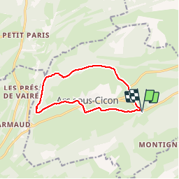
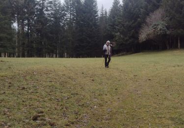
Tour Wandern von 10,8 km verfügbar auf Burgund und Freigrafschaft, Doubs, Arc-sous-Cicon. Diese Tour wird von eltonnermou vorgeschlagen.
Beschreibung
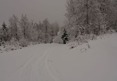
Randonnée pieds propres (hors période neigeuse).
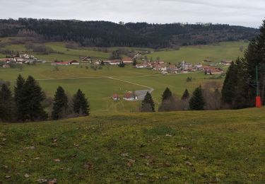
découvrir la plaine et les sous bois de ce joli village.
Ort
Land:
France
Region :
Burgund und Freigrafschaft
Abteilung/Provinz :
Doubs
Kommune :
Arc-sous-Cicon
Standort:
Unknown
Gehen Sie:(Dec)
Gehen Sie:(UTM)
303215 ; 5213889 (32T) N.
Kommentare
Touren in der Umgebung
![Tour Wandern La Chaux - la petite chaux - Photo](https://media.geolcdn.com/t/375/260/7a6c584e-6397-4b14-80f1-7a8ab67999c5.jpg&format=jpg&maxdim=2)
![Wandern Wandern](https://static1.geolcdn.com/sitytour/trail-icons/101.png)
la petite chaux
Wandern
Einfach
(1)
La Chaux,
Burgund und Freigrafschaft,
Doubs,
France
![](/images/other/stat-length.png)
15,1 km | 20 km-effort
2h 40min
![](https://static1.geolcdn.com/siteimages/upload/files/16400158638029165_repeat_loop_refresh_sync_direction_icon.png)
Ja
![Tour Wandern Arc-sous-Cicon - CRET MONNIOT - Photo](https://media.geolcdn.com/t/375/260/d97d8e88-0910-4675-bcfd-b68f91380fab.jpg&format=jpg&maxdim=2)
![Wandern Wandern](https://static1.geolcdn.com/sitytour/trail-icons/101.png)
CRET MONNIOT
Wandern
Medium
Arc-sous-Cicon,
Burgund und Freigrafschaft,
Doubs,
France
![](/images/other/stat-length.png)
19,4 km | 26 km-effort
3h 40min
![](https://static1.geolcdn.com/siteimages/upload/files/16400158638029165_repeat_loop_refresh_sync_direction_icon.png)
Ja
![Tour Schneeschuhwandern Arc-sous-Cicon - ARC SOUS CICON](https://media.geolcdn.com/t/375/260/19b8c976-4c9f-4655-b7e5-28069cdc97a8.jpg&format=jpg&maxdim=2)
![Schneeschuhwandern Schneeschuhwandern](https://static1.geolcdn.com/sitytour/trail-icons/504.png)
ARC SOUS CICON "LA CÔTE"
Schneeschuhwandern
Einfach
Arc-sous-Cicon,
Burgund und Freigrafschaft,
Doubs,
France
![](/images/other/stat-length.png)
9,4 km | 12,9 km-effort
2h 41min
![](https://static1.geolcdn.com/siteimages/upload/files/16400158638029165_repeat_loop_refresh_sync_direction_icon.png)
Ja
![Tour Schneeschuhwandern Les Premiers-Sapins - rando raquettes Nods - Photo](https://media.geolcdn.com/t/375/260/f2560bde-7dd4-49dd-a0d9-4fe4eccb3f0d.jpg&format=jpg&maxdim=2)
![Schneeschuhwandern Schneeschuhwandern](https://static1.geolcdn.com/sitytour/trail-icons/504.png)
rando raquettes Nods
Schneeschuhwandern
Sehr leicht
Les Premiers-Sapins,
Burgund und Freigrafschaft,
Doubs,
France
![](/images/other/stat-length.png)
11,5 km | 0 m-effort
4h 26min
![](https://static1.geolcdn.com/siteimages/upload/files/16400158638029165_repeat_loop_refresh_sync_direction_icon.png)
Ja
![Tour Schneeschuhwandern La Chaux - Cret Moniot raquettes CAF - Photo](https://media.geolcdn.com/t/375/260/ext.jpg?maxdim=2&url=https%3A%2F%2Fservices.sitytrail.com%2FGeolivesWS%2FDownloadMedia.ashx%3FTrailID%3D1117380%26Media%3Dfix__20190219101445.jpg)
![Schneeschuhwandern Schneeschuhwandern](https://static1.geolcdn.com/sitytour/trail-icons/504.png)
Cret Moniot raquettes CAF
Schneeschuhwandern
Schwierig
La Chaux,
Burgund und Freigrafschaft,
Doubs,
France
![](/images/other/stat-length.png)
14,8 km | 19,9 km-effort
5h 52min
![](https://static1.geolcdn.com/siteimages/upload/files/16400158638029165_repeat_loop_refresh_sync_direction_icon.png)
Ja
![Tour Wandern Les Premiers-Sapins - 2013-12-21(Charmeux) - Photo](https://media.geolcdn.com/t/375/260/ext.jpg?maxdim=2&url=https%3A%2F%2Fservices.sitytrail.com%2FGeolivesWS%2FDownloadMedia.ashx%3FTrailID%3D238250%26Media%3D20131221113320.jpg)
![Wandern Wandern](https://static1.geolcdn.com/sitytour/trail-icons/101.png)
2013-12-21(Charmeux)
Wandern
Einfach
Les Premiers-Sapins,
Burgund und Freigrafschaft,
Doubs,
France
![](/images/other/stat-length.png)
4,8 km | 6,5 km-effort
1h 20min
![](https://static1.geolcdn.com/siteimages/upload/files/16400158638029165_repeat_loop_refresh_sync_direction_icon.png)
Nein
![Tour Wandern Arc-sous-Cicon - Le Crêt Monniot (1141 m) depuis Les Cordiers - Photo](https://media.geolcdn.com/t/375/260/ext.jpg?maxdim=2&url=https%3A%2F%2Fservices.sitytrail.com%2FGeolivesWS%2FDownloadMedia.ashx%3FTrailID%3D108775%26Media%3D1917_2.jpg)
![Wandern Wandern](https://static1.geolcdn.com/sitytour/trail-icons/101.png)
Le Crêt Monniot (1141 m) depuis Les Cordiers
Wandern
Medium
Arc-sous-Cicon,
Burgund und Freigrafschaft,
Doubs,
France
![](/images/other/stat-length.png)
11,3 km | 16,2 km-effort
3h 30min
![](https://static1.geolcdn.com/siteimages/upload/files/16400158638029165_repeat_loop_refresh_sync_direction_icon.png)
Ja
![Tour Schneeschuhwandern La Chaux - Le Cret Moniot - Photo](https://media.geolcdn.com/t/375/260/ext.jpg?maxdim=2&url=https%3A%2F%2Fservices.sitytrail.com%2FGeolivesWS%2FDownloadMedia.ashx%3FTrailID%3D104418%26Media%3D7653_1.jpg)
![Schneeschuhwandern Schneeschuhwandern](https://static1.geolcdn.com/sitytour/trail-icons/504.png)
Le Cret Moniot
Schneeschuhwandern
Medium
La Chaux,
Burgund und Freigrafschaft,
Doubs,
France
![](/images/other/stat-length.png)
30 km | 38 km-effort
3h 4min
![](https://static1.geolcdn.com/siteimages/upload/files/16400158638029165_repeat_loop_refresh_sync_direction_icon.png)
Ja
![Tour Wandern Passonfontaine - essai pré de vaire - Photo](https://media.geolcdn.com/t/375/260/7e193236-5399-4062-b09c-c4d33fed1a3d.jpg&format=jpg&maxdim=2)
![Wandern Wandern](https://static1.geolcdn.com/sitytour/trail-icons/101.png)
essai pré de vaire
Wandern
Einfach
Passonfontaine,
Burgund und Freigrafschaft,
Doubs,
France
![](/images/other/stat-length.png)
4 km | 5,4 km-effort
1h 11min
![](https://static1.geolcdn.com/siteimages/upload/files/16400158638029165_repeat_loop_refresh_sync_direction_icon.png)
Nein