![](/images/other/stat-length.png)
![Tour Wandern Châtel - covagnes - Photo](https://media.geolcdn.com/t/1900/400/00c22ec1-9145-4b8b-81f9-38dc60e42f87.jpg&format=pjpeg&maxdim=2)
covagnes
GuyVachet
Benutzer
![Länge](/images/other/stat-length.png)
![Maximale Höhe](https://static1.geolcdn.com/siteimages/upload/files/1508320355ic_sort_altitude_max_24dp.png)
![Positive Höhendifferenz](https://static1.geolcdn.com/siteimages/upload/files/1508320355ic_sort_den_pos_24dp.png)
![Km-Effort](/images/other/stat-length.png)
![Min. Höhe](https://static1.geolcdn.com/siteimages/upload/files/1508320355ic_sort_altitude_min_24dp.png)
![Negative Höhendifferenz](https://static1.geolcdn.com/siteimages/upload/files/1508320355ic_sort_den_neg_24dp.png)
![Boucle](https://static1.geolcdn.com/siteimages/upload/files/16400158638029165_repeat_loop_refresh_sync_direction_icon.png)
![Wandern](https://static1.geolcdn.com/sitytour/trail-icons/101.png)
3h16
Schwierigkeit : Einfach
![Scannen Sie diesen QR-Code, um die Tour in der SityTrail-Anwendung zu öffnen](https://capi.geolives.com/qq0zvz2zws4bq2lad0pu/sitytour/trails/2126018/qr.png?size=200)
Kostenlosegpshiking-Anwendung
Über SityTrail
Tour Wandern von 7,7 km verfügbar auf Auvergne-Rhone-Alpen, Hochsavoyen, Châtel. Diese Tour wird von GuyVachet vorgeschlagen.
Beschreibung
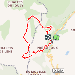
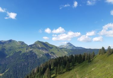
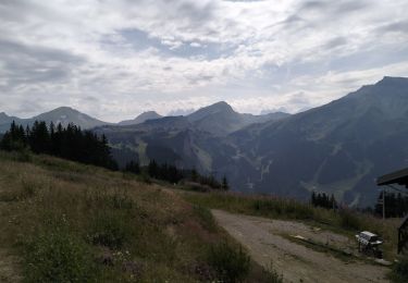
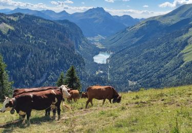
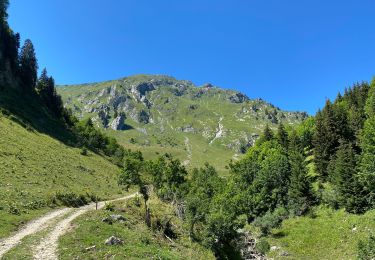
Boucle par les alpages de Betzalin et Covagnes au départ de Pré la Joux au coeur d'un site Natura 2000. Traverser la Dranse d'Abondance et monter via un sentier un peu raide (!) qui quitte à droite la piste forestière au bout de 200m. Prendre à gauche juste après Betzalin (photo 1) pour monter aux chalets de Covagnes et au-dessus couper le GR5 à 1725m. Redescendre avec rapidement les chalets de Lens en vue (photo 2) et à la cote 1622 prendre à gauche pour un petit raccourci (sentier peu marqué mais facile à suivre) qui retrouve le GR5 (prendre à gauche) et la descente se termine en lacets jusqu'au point de départ.
Ort
Kommentare
Touren in der Umgebung
![Tour Wandern Châtel - Mont de grange depuis le col de Bassachaux - Photo](https://media.geolcdn.com/t/375/260/ext.jpg?maxdim=2&url=https%3A%2F%2Fservices.sitytrail.com%2FGeolivesWS%2FDownloadMedia.ashx%3FTrailID%3D306971%26Media%3Dfix__20140529130822.jpg)
![Wandern Wandern](https://static1.geolcdn.com/sitytour/trail-icons/101.png)
Wandern
![](/images/other/stat-length.png)
![](https://static1.geolcdn.com/siteimages/upload/files/16400158638029165_repeat_loop_refresh_sync_direction_icon.png)
![Tour Wandern Abondance - Le Mont de Grange, 2432m - Photo](https://media.geolcdn.com/t/375/260/ext.jpg?maxdim=2&url=https%3A%2F%2Fservices.sitytrail.com%2FGeolivesWS%2FDownloadMedia.ashx%3FTrailID%3D172598%26Media%3D13962_1.jpg)
![Wandern Wandern](https://static1.geolcdn.com/sitytour/trail-icons/101.png)
Wandern
![](/images/other/stat-length.png)
![](https://static1.geolcdn.com/siteimages/upload/files/16400158638029165_repeat_loop_refresh_sync_direction_icon.png)
![Tour Wandern Morzine - balade des crêtes : Avoriaz . belvédère du lac de Montriond . croix des combes . Avoriaz - Photo](https://media.geolcdn.com/t/375/260/f4d442e1-fe36-4b17-a99a-0349118a63ec.jpg&format=jpg&maxdim=2)
![Wandern Wandern](https://static1.geolcdn.com/sitytour/trail-icons/101.png)
Wandern
![](/images/other/stat-length.png)
![](https://static1.geolcdn.com/siteimages/upload/files/16400158638029165_repeat_loop_refresh_sync_direction_icon.png)
![Tour Schneeschuhwandern Châtel - Petite Châtel - Photo](https://media.geolcdn.com/t/375/260/ext.jpg?maxdim=2&url=https%3A%2F%2Fservices.sitytrail.com%2FGeolivesWS%2FDownloadMedia.ashx%3FTrailID%3D1119269%26Media%3Db7d0cc1f-c4ed-4071-ac32-dc424d2d5cb2.JPG)
![Schneeschuhwandern Schneeschuhwandern](https://static1.geolcdn.com/sitytour/trail-icons/504.png)
Schneeschuhwandern
![](/images/other/stat-length.png)
![](https://static1.geolcdn.com/siteimages/upload/files/16400158638029165_repeat_loop_refresh_sync_direction_icon.png)
![Tour Schneeschuhwandern Châtel - Randonnée entre la France et la suisse - Photo](https://media.geolcdn.com/t/375/260/ext.jpg?maxdim=2&url=https%3A%2F%2Fservices.sitytrail.com%2FGeolivesWS%2FDownloadMedia.ashx%3FTrailID%3D1112741%26Media%3De2e8baa9-2838-4264-9b00-955ab2207789.JPG)
![Schneeschuhwandern Schneeschuhwandern](https://static1.geolcdn.com/sitytour/trail-icons/504.png)
Schneeschuhwandern
![](/images/other/stat-length.png)
![](https://static1.geolcdn.com/siteimages/upload/files/16400158638029165_repeat_loop_refresh_sync_direction_icon.png)
![Tour Wandern Morzine - Arête de super Morzine - Photo](https://media.geolcdn.com/t/375/260/2f97f0ba-3061-4f5a-be28-27baf6b86989.jpg&format=jpg&maxdim=2)
![Wandern Wandern](https://static1.geolcdn.com/sitytour/trail-icons/101.png)
Wandern
![](/images/other/stat-length.png)
![](https://static1.geolcdn.com/siteimages/upload/files/16400158638029165_repeat_loop_refresh_sync_direction_icon.png)
![Tour Wandern Morzine - 74-Avoriaz-cretes-belvedere-10km-360 - Photo](https://media.geolcdn.com/t/375/260/25538cc4-cfbb-49c4-b268-c30134a766c6.jpg&format=jpg&maxdim=2)
![Wandern Wandern](https://static1.geolcdn.com/sitytour/trail-icons/101.png)
Wandern
![](/images/other/stat-length.png)
![](https://static1.geolcdn.com/siteimages/upload/files/16400158638029165_repeat_loop_refresh_sync_direction_icon.png)
![Tour Wandern Abondance - Col de Bassachaux le lac vert 7 juillet 2022 - Photo](https://media.geolcdn.com/t/375/260/6bdd057f-20dc-4f51-87e3-ee4bf24e76cf.jpg&format=jpg&maxdim=2)
![Wandern Wandern](https://static1.geolcdn.com/sitytour/trail-icons/101.png)
Wandern
![](/images/other/stat-length.png)
![](https://static1.geolcdn.com/siteimages/upload/files/16400158638029165_repeat_loop_refresh_sync_direction_icon.png)
![Tour Wandern Châtel - Les Mattes - Photo](https://media.geolcdn.com/t/375/260/98db01ae-d3f3-470a-a229-cdc13a6d9134.jpg&format=jpg&maxdim=2)
![Wandern Wandern](https://static1.geolcdn.com/sitytour/trail-icons/101.png)
Wandern
![](/images/other/stat-length.png)
![](https://static1.geolcdn.com/siteimages/upload/files/16400158638029165_repeat_loop_refresh_sync_direction_icon.png)