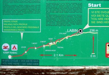
![](/images/other/stat-length.png)
![Tour Elektrofahrrad Presika - J4-LABIN-PULA - Photo](https://media.geolcdn.com/t/1900/400/69b2ceea-95f7-42ff-8d2b-007ddef0493a.jpg&format=pjpeg&maxdim=2)
J4-LABIN-PULA
leeho
Benutzer
![Länge](/images/other/stat-length.png)
![Maximale Höhe](https://static1.geolcdn.com/siteimages/upload/files/1508320355ic_sort_altitude_max_24dp.png)
![Positive Höhendifferenz](https://static1.geolcdn.com/siteimages/upload/files/1508320355ic_sort_den_pos_24dp.png)
![Km-Effort](/images/other/stat-length.png)
![Min. Höhe](https://static1.geolcdn.com/siteimages/upload/files/1508320355ic_sort_altitude_min_24dp.png)
![Negative Höhendifferenz](https://static1.geolcdn.com/siteimages/upload/files/1508320355ic_sort_den_neg_24dp.png)
![Boucle](https://static1.geolcdn.com/siteimages/upload/files/16400158638029165_repeat_loop_refresh_sync_direction_icon.png)
![Elektrofahrrad](https://static1.geolcdn.com/sitytour/trail-icons/205.png)
--
Schwierigkeit : Einfach
![Scannen Sie diesen QR-Code, um die Tour in der SityTrail-Anwendung zu öffnen](https://capi.geolives.com/qq0zvz2zws4bq2lad0pu/sitytour/trails/2121454/qr.png?size=200)
Kostenlosegpshiking-Anwendung
Über SityTrail
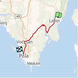
Tour Elektrofahrrad von 52 km verfügbar auf Unbekannt, Gespanschaft Istrien. Diese Tour wird von leeho vorgeschlagen.
Beschreibung
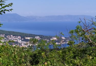
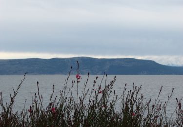
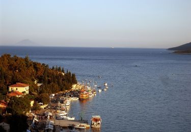
Après le petit-déjeuner, vous partez pour Rasa puis Barban. En route, vous passerez par la réserve naturelle de « Liburna ». Vous arriverez enfin à Pula, la plus grande ville d’Istrie. Riche en monuments de l’époque romaine, vous ne pourrez pas manquer son amphithéâtre, un des plus grands et des mieux conservés au monde.
Environ 51 à 58km à vélo.
Ort
Kommentare
Touren in der Umgebung
![Tour Zu Fuß - Staza svete Barbare (Labin - Kapelica - Raša) - Photo](https://media.geolcdn.com/t/375/260/92d929e7-f9f2-4380-af70-b6952281b5b1.jpeg&format=jpg&maxdim=2)
![Zu Fuß Zu Fuß](https://static1.geolcdn.com/sitytour/trail-icons/100.png)
Zu Fuß
![](/images/other/stat-length.png)
![](https://static1.geolcdn.com/siteimages/upload/files/16400158638029165_repeat_loop_refresh_sync_direction_icon.png)
![Tour Zu Fuß - Šetnica skirivenih čari (Sv.Andrija - Prižnja - Prohaska - Sv.Andrija) - Photo](https://media.geolcdn.com/t/375/260/8a718095-d900-46e8-a808-07aa714c8273.jpeg&format=jpg&maxdim=2)
![Zu Fuß Zu Fuß](https://static1.geolcdn.com/sitytour/trail-icons/100.png)
Zu Fuß
![](/images/other/stat-length.png)
![](https://static1.geolcdn.com/siteimages/upload/files/16400158638029165_repeat_loop_refresh_sync_direction_icon.png)
![Tour Zu Fuß - Staza božanskih izvora (Rabač - Labin) - Photo](https://media.geolcdn.com/t/375/260/d1341b4b-837c-4f20-9975-0875322f3656.jpeg&format=jpg&maxdim=2)
![Zu Fuß Zu Fuß](https://static1.geolcdn.com/sitytour/trail-icons/100.png)
Zu Fuß
![](/images/other/stat-length.png)
![](https://static1.geolcdn.com/siteimages/upload/files/16400158638029165_repeat_loop_refresh_sync_direction_icon.png)
![Tour Zu Fuß - Staza Terra Magica (Rabac - Prtlog - Gondolići - Rabač) - Photo](https://media.geolcdn.com/t/375/260/1ca390a2-0a17-4c3a-b8c2-9eb2b26310a8.jpeg&format=jpg&maxdim=2)
![Zu Fuß Zu Fuß](https://static1.geolcdn.com/sitytour/trail-icons/100.png)
Zu Fuß
![](/images/other/stat-length.png)
![](https://static1.geolcdn.com/siteimages/upload/files/16400158638029165_repeat_loop_refresh_sync_direction_icon.png)
![Tour Zu Fuß - Staza Svetog Justa (Labin - Gondolići - Rabač) - Photo](https://media.geolcdn.com/t/375/260/32bec582-10c6-477b-a338-ba39d025a35c.jpeg&format=jpg&maxdim=2)
![Zu Fuß Zu Fuß](https://static1.geolcdn.com/sitytour/trail-icons/100.png)
Zu Fuß
![](/images/other/stat-length.png)
![](https://static1.geolcdn.com/siteimages/upload/files/16400158638029165_repeat_loop_refresh_sync_direction_icon.png)
![Tour Zu Fuß - Sentonina staza (Labin - Rabač) - Photo](https://media.geolcdn.com/t/375/260/f753b171-712f-41e5-af8b-42ac7963ef77.jpeg&format=jpg&maxdim=2)
![Zu Fuß Zu Fuß](https://static1.geolcdn.com/sitytour/trail-icons/100.png)
Zu Fuß
![](/images/other/stat-length.png)
![](https://static1.geolcdn.com/siteimages/upload/files/16400158638029165_repeat_loop_refresh_sync_direction_icon.png)
![Tour Zu Fuß - Bellavista (Rabac - Ripenda Kosi - Standar - Rabac) - Photo](https://media.geolcdn.com/t/375/260/ext.jpg?maxdim=2&url=https%3A%2F%2Fstatic1.geolcdn.com%2Fsiteimages%2Fupload%2Ffiles%2F1545311037marcheuse_200dpi.jpg)
![Zu Fuß Zu Fuß](https://static1.geolcdn.com/sitytour/trail-icons/100.png)
Zu Fuß
![](/images/other/stat-length.png)
![](https://static1.geolcdn.com/siteimages/upload/files/16400158638029165_repeat_loop_refresh_sync_direction_icon.png)
![Tour Wandern - Labin - Photo](https://media.geolcdn.com/t/375/260/f14dc5e2-8333-4b71-8755-8720458d4d90.jpg&format=jpg&maxdim=2)
![Wandern Wandern](https://static1.geolcdn.com/sitytour/trail-icons/101.png)