![](/images/other/stat-length.png)
![Tour Wandern Épinal - SityTrail - Circuit St Antoine - Bouzey - Photo](https://media.geolcdn.com/t/1900/400/ext.pjpeg?maxdim=2&url=https%3A%2F%2Fstatic1.geolcdn.com%2Fsiteimages%2Fupload%2Ffiles%2F1553511878bg_sport_marche.png)
SityTrail - Circuit St Antoine - Bouzey
BernardHumeau
Benutzer
![Länge](/images/other/stat-length.png)
Länge
19,7 km
![Maximale Höhe](https://static1.geolcdn.com/siteimages/upload/files/1508320355ic_sort_altitude_max_24dp.png)
Maximale Höhe
473 m
![Positive Höhendifferenz](https://static1.geolcdn.com/siteimages/upload/files/1508320355ic_sort_den_pos_24dp.png)
Positive Höhendifferenz
470 m
![Km-Effort](/images/other/stat-length.png)
Km-Effort
26 km
![Min. Höhe](https://static1.geolcdn.com/siteimages/upload/files/1508320355ic_sort_altitude_min_24dp.png)
Min. Höhe
334 m
![Negative Höhendifferenz](https://static1.geolcdn.com/siteimages/upload/files/1508320355ic_sort_den_neg_24dp.png)
Negative Höhendifferenz
470 m
![Boucle](https://static1.geolcdn.com/siteimages/upload/files/16400158638029165_repeat_loop_refresh_sync_direction_icon.png)
Boucle
Ja
Erstellungsdatum :
2019-06-22 16:45:45.212
Letzte Änderung :
2019-06-23 14:34:37.54
![Wandern](https://static1.geolcdn.com/sitytour/trail-icons/101.png)
5h32
Schwierigkeit : Schwierig
![Scannen Sie diesen QR-Code, um die Tour in der SityTrail-Anwendung zu öffnen](https://capi.geolives.com/qq0zvz2zws4bq2lad0pu/sitytour/trails/2121059/qr.png?size=200)
Kostenlosegpshiking-Anwendung
Über SityTrail
Tour Wandern von 19,7 km verfügbar auf Großer Osten, Vogesen, Épinal. Diese Tour wird von BernardHumeau vorgeschlagen.
Beschreibung
Très long circuit de 18.5 kms au travers les forets d'Epinal jusqu'à Bouzey. Ce circuit passe par le bois de la Contesse et le bois d'Uxegney.
Ort
Land:
France
Region :
Großer Osten
Abteilung/Provinz :
Vogesen
Kommune :
Épinal
Standort:
Unknown
Gehen Sie:(Dec)
Gehen Sie:(UTM)
310368 ; 5337282 (32U) N.
Kommentare
Touren in der Umgebung
![Tour sport Épinal - Golbey - Photo](https://media.geolcdn.com/t/375/260/ext.jpg?maxdim=2&url=https%3A%2F%2Fsecurestorage.geolives.com%2Fsitytour%2Ftrail-bg%2Fdefault.jpg)
Golbey
sport
Sehr leicht
(1)
Épinal,
Großer Osten,
Vogesen,
France
![](/images/other/stat-length.png)
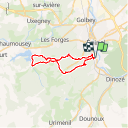
7,1 km | 7,8 km-effort
Unbekannt
![](https://static1.geolcdn.com/siteimages/upload/files/16400158638029165_repeat_loop_refresh_sync_direction_icon.png)
Ja
![Tour Wandern Épinal - Epinal - Photo](https://media.geolcdn.com/t/375/260/940302e4-e305-4d1c-a286-7e159c6cde8b.jpg&format=jpg&maxdim=2)
![Wandern Wandern](https://static1.geolcdn.com/sitytour/trail-icons/101.png)
![Tour Wandern Épinal - humbertois les ,2lacs - Photo](https://media.geolcdn.com/t/375/260/c469247b-9bb0-491c-9204-6b2729eb7b0d.jpg&format=jpg&maxdim=2)
![Wandern Wandern](https://static1.geolcdn.com/sitytour/trail-icons/101.png)
humbertois les ,2lacs
Wandern
Medium
Épinal,
Großer Osten,
Vogesen,
France
![](/images/other/stat-length.png)
7,3 km | 8,9 km-effort
1h 55min
![](https://static1.geolcdn.com/siteimages/upload/files/16400158638029165_repeat_loop_refresh_sync_direction_icon.png)
Ja
![Tour Zu Fuß Épinal - uzefaing 2 la grenouille - Photo](https://media.geolcdn.com/t/375/260/bbcf75ae-233b-421b-ab5d-c893e05cb26f.jpg&format=jpg&maxdim=2)
![Zu Fuß Zu Fuß](https://static1.geolcdn.com/sitytour/trail-icons/100.png)
uzefaing 2 la grenouille
Zu Fuß
Medium
Épinal,
Großer Osten,
Vogesen,
France
![](/images/other/stat-length.png)
18,1 km | 23 km-effort
5h 17min
![](https://static1.geolcdn.com/siteimages/upload/files/16400158638029165_repeat_loop_refresh_sync_direction_icon.png)
Ja
![Tour Rennrad Épinal - epinal florémont bouxières - Photo](https://media.geolcdn.com/t/375/260/ext.jpg?maxdim=2&url=https%3A%2F%2Fstatic1.geolcdn.com%2Fsiteimages%2Fupload%2Ffiles%2F1524743154velo.jpg)
![Rennrad Rennrad](https://static1.geolcdn.com/sitytour/trail-icons/201.png)
epinal florémont bouxières
Rennrad
Medium
(1)
Épinal,
Großer Osten,
Vogesen,
France
![](/images/other/stat-length.png)
93 km | 110 km-effort
6h 26min
![](https://static1.geolcdn.com/siteimages/upload/files/16400158638029165_repeat_loop_refresh_sync_direction_icon.png)
Ja
![Tour Wandern Épinal - ste Barbe - Photo](https://media.geolcdn.com/t/375/260/ext.jpg?maxdim=2&url=https%3A%2F%2Fservices.sitytrail.com%2FGeolivesWS%2FDownloadMedia.ashx%3FTrailID%3D1071507%26Media%3Dfix__20181114151145.jpg)
![Wandern Wandern](https://static1.geolcdn.com/sitytour/trail-icons/101.png)
ste Barbe
Wandern
Sehr leicht
Épinal,
Großer Osten,
Vogesen,
France
![](/images/other/stat-length.png)
6,7 km | 9 km-effort
1h 55min
![](https://static1.geolcdn.com/siteimages/upload/files/16400158638029165_repeat_loop_refresh_sync_direction_icon.png)
Ja
![Tour Wandern Épinal - 2016 03 22 - Photo](https://media.geolcdn.com/t/375/260/ext.jpg?maxdim=2&url=https%3A%2F%2Fservices.sitytrail.com%2FGeolivesWS%2FDownloadMedia.ashx%3FTrailID%3D542217%26Media%3Dfix__20160322163522.jpg)
![Wandern Wandern](https://static1.geolcdn.com/sitytour/trail-icons/101.png)
![Tour Andere Aktivitäten Épinal - Grand Est - Ligne 18 - Epinal St Diè - Photo](https://media.geolcdn.com/t/375/260/ext.jpg?maxdim=2&url=https%3A%2F%2Fservices.sitytrail.com%2FGeolivesWS%2FDownloadMedia.ashx%3FTrailID%3D449149%26Media%3D79b8c567-20fe-4c86-8015-3c376b29db07.jpg)
![Andere Aktivitäten Andere Aktivitäten](https://static1.geolcdn.com/sitytour/trail-icons/900.png)
Grand Est - Ligne 18 - Epinal St Diè
Andere Aktivitäten
Sehr leicht
Épinal,
Großer Osten,
Vogesen,
France
![](/images/other/stat-length.png)
61 km | 68 km-effort
5min
![](https://static1.geolcdn.com/siteimages/upload/files/16400158638029165_repeat_loop_refresh_sync_direction_icon.png)
Nein
![Tour Andere Aktivitäten Épinal - Grand Est - Ligne 18,7 - Epinal Remiremont - Photo](https://media.geolcdn.com/t/375/260/ext.jpg?maxdim=2&url=https%3A%2F%2Fservices.sitytrail.com%2FGeolivesWS%2FDownloadMedia.ashx%3FTrailID%3D448459%26Media%3Da6bb1b53-2dd3-47d4-9651-180d18084675.jpg)
![Andere Aktivitäten Andere Aktivitäten](https://static1.geolcdn.com/sitytour/trail-icons/900.png)
Grand Est - Ligne 18,7 - Epinal Remiremont
Andere Aktivitäten
Sehr leicht
Épinal,
Großer Osten,
Vogesen,
France
![](/images/other/stat-length.png)
27 km | 31 km-effort
5min
![](https://static1.geolcdn.com/siteimages/upload/files/16400158638029165_repeat_loop_refresh_sync_direction_icon.png)
Nein