![](/images/other/stat-length.png)
![Tour Radtourismus Vaulx-Milieu - Vaulx-Milieu - Hauterives - Photo](https://media.geolcdn.com/t/1900/400/748d830b-5085-42c2-ad8c-645514155463.jpg&format=pjpeg&maxdim=2)
Vaulx-Milieu - Hauterives
karawatsj
Benutzer
![Länge](/images/other/stat-length.png)
Länge
61 km
![Maximale Höhe](https://static1.geolcdn.com/siteimages/upload/files/1508320355ic_sort_altitude_max_24dp.png)
Maximale Höhe
543 m
![Positive Höhendifferenz](https://static1.geolcdn.com/siteimages/upload/files/1508320355ic_sort_den_pos_24dp.png)
Positive Höhendifferenz
1059 m
![Km-Effort](/images/other/stat-length.png)
Km-Effort
75 km
![Min. Höhe](https://static1.geolcdn.com/siteimages/upload/files/1508320355ic_sort_altitude_min_24dp.png)
Min. Höhe
228 m
![Negative Höhendifferenz](https://static1.geolcdn.com/siteimages/upload/files/1508320355ic_sort_den_neg_24dp.png)
Negative Höhendifferenz
990 m
![Boucle](https://static1.geolcdn.com/siteimages/upload/files/16400158638029165_repeat_loop_refresh_sync_direction_icon.png)
Boucle
Nein
Erstellungsdatum :
2019-06-15 06:43:20.634
Letzte Änderung :
2019-06-15 16:42:10.039
![Radtourismus](https://static1.geolcdn.com/sitytour/trail-icons/204.png)
3h19
Schwierigkeit : Schwierig
![Scannen Sie diesen QR-Code, um die Tour in der SityTrail-Anwendung zu öffnen](https://capi.geolives.com/qq0zvz2zws4bq2lad0pu/sitytour/trails/2114862/qr.png?size=200)
Kostenlosegpshiking-Anwendung
Über SityTrail
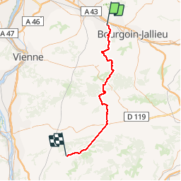
Tour Radtourismus von 61 km verfügbar auf Auvergne-Rhone-Alpen, Isère, Vaulx-Milieu. Diese Tour wird von karawatsj vorgeschlagen.
Beschreibung
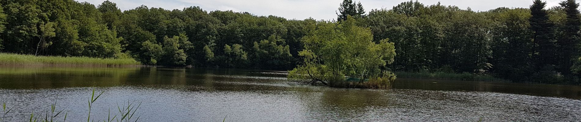
Mooie tocht door Auvergne-Isère en het vijvergebied rond Lieudieu. Wel heel vermoeiend.
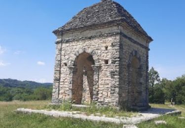
Palais Ideal in Hauterives is echt de moeite om te bezoeken.
Ort
Land:
France
Region :
Auvergne-Rhone-Alpen
Abteilung/Provinz :
Isère
Kommune :
Vaulx-Milieu
Standort:
Unknown
Gehen Sie:(Dec)
Gehen Sie:(UTM)
670086 ; 5053278 (31T) N.
Kommentare
Touren in der Umgebung
![Tour Wandern Bonnefamille - Bonne Famille - Photo](https://media.geolcdn.com/t/375/260/ext.jpg?maxdim=2&url=https%3A%2F%2Fstatic1.geolcdn.com%2Fsiteimages%2Fupload%2Ffiles%2F1553511878bg_sport_marche.png)
![Wandern Wandern](https://static1.geolcdn.com/sitytour/trail-icons/101.png)
Bonne Famille
Wandern
Sehr leicht
(1)
Bonnefamille,
Auvergne-Rhone-Alpen,
Isère,
France
![](/images/other/stat-length.png)
8,4 km | 10,6 km-effort
2h 23min
![](https://static1.geolcdn.com/siteimages/upload/files/16400158638029165_repeat_loop_refresh_sync_direction_icon.png)
Ja
![Tour Wandern L'Isle-d'Abeau - promenade - Photo](https://media.geolcdn.com/t/375/260/ext.jpg?maxdim=2&url=https%3A%2F%2Fstatic1.geolcdn.com%2Fsiteimages%2Fupload%2Ffiles%2F1553511878bg_sport_marche.png)
![Wandern Wandern](https://static1.geolcdn.com/sitytour/trail-icons/101.png)
promenade
Wandern
Sehr leicht
(2)
L'Isle-d'Abeau,
Auvergne-Rhone-Alpen,
Isère,
France
![](/images/other/stat-length.png)
4 km | 4,8 km-effort
59min
![](https://static1.geolcdn.com/siteimages/upload/files/16400158638029165_repeat_loop_refresh_sync_direction_icon.png)
Ja
![Mountainbike Mountainbike](https://static1.geolcdn.com/sitytour/trail-icons/202.png)
Les étangs et le golf
Mountainbike
Vaulx-Milieu,
Auvergne-Rhone-Alpen,
Isère,
France
![](/images/other/stat-length.png)
13,1 km | 16,1 km-effort
1h 18min
![](https://static1.geolcdn.com/siteimages/upload/files/16400158638029165_repeat_loop_refresh_sync_direction_icon.png)
Nein
![Tour Wandern Vaulx-Milieu - vaulx - Photo](https://media.geolcdn.com/t/375/260/ext.jpg?maxdim=2&url=https%3A%2F%2Fservices.sitytrail.com%2FGeolivesWS%2FDownloadMedia.ashx%3FTrailID%3D367906%26Media%3Dfix__20141202151815.jpg)
![Wandern Wandern](https://static1.geolcdn.com/sitytour/trail-icons/101.png)
vaulx
Wandern
Sehr leicht
Vaulx-Milieu,
Auvergne-Rhone-Alpen,
Isère,
France
![](/images/other/stat-length.png)
7,1 km | 9 km-effort
2h 2min
![](https://static1.geolcdn.com/siteimages/upload/files/16400158638029165_repeat_loop_refresh_sync_direction_icon.png)
Ja
![Tour Fahrrad L'Isle-d'Abeau - Septeme - Photo](https://media.geolcdn.com/t/375/260/ext.jpg?maxdim=2&url=https%3A%2F%2Fstatic1.geolcdn.com%2Fsiteimages%2Fupload%2Ffiles%2F1524743154velo.jpg)
![Fahrrad Fahrrad](https://static1.geolcdn.com/sitytour/trail-icons/200.png)
Septeme
Fahrrad
Medium
(1)
L'Isle-d'Abeau,
Auvergne-Rhone-Alpen,
Isère,
France
![](/images/other/stat-length.png)
46 km | 54 km-effort
2h 24min
![](https://static1.geolcdn.com/siteimages/upload/files/16400158638029165_repeat_loop_refresh_sync_direction_icon.png)
Ja
![Tour Wandern L'Isle-d'Abeau - balade en forêt - Photo](https://media.geolcdn.com/t/375/260/ext.jpg?maxdim=2&url=https%3A%2F%2Fservices.sitytrail.com%2FGeolivesWS%2FDownloadMedia.ashx%3FTrailID%3D239654%26Media%3Dfix__20131231114228.jpg)
![Wandern Wandern](https://static1.geolcdn.com/sitytour/trail-icons/101.png)
balade en forêt
Wandern
Einfach
L'Isle-d'Abeau,
Auvergne-Rhone-Alpen,
Isère,
France
![](/images/other/stat-length.png)
8,1 km | 9,9 km-effort
2h 1min
![](https://static1.geolcdn.com/siteimages/upload/files/16400158638029165_repeat_loop_refresh_sync_direction_icon.png)
Ja
![Tour Wandern L'Isle-d'Abeau - balade en forêt - Photo](https://media.geolcdn.com/t/375/260/ext.jpg?maxdim=2&url=https%3A%2F%2Fservices.sitytrail.com%2FGeolivesWS%2FDownloadMedia.ashx%3FTrailID%3D239653%26Media%3Dfix__20131231114228.jpg)
![Wandern Wandern](https://static1.geolcdn.com/sitytour/trail-icons/101.png)
balade en forêt
Wandern
Einfach
L'Isle-d'Abeau,
Auvergne-Rhone-Alpen,
Isère,
France
![](/images/other/stat-length.png)
8,1 km | 9,9 km-effort
2h 1min
![](https://static1.geolcdn.com/siteimages/upload/files/16400158638029165_repeat_loop_refresh_sync_direction_icon.png)
Ja
![Tour Wandern Domarin - DOMARIN 15 01 2021 - Photo](https://media.geolcdn.com/t/375/260/82a08577-40a9-44e3-a3f3-673eaf00c08e.jpg&format=jpg&maxdim=2)
![Wandern Wandern](https://static1.geolcdn.com/sitytour/trail-icons/101.png)
DOMARIN 15 01 2021
Wandern
Einfach
Domarin,
Auvergne-Rhone-Alpen,
Isère,
France
![](/images/other/stat-length.png)
10,2 km | 14 km-effort
2h 42min
![](https://static1.geolcdn.com/siteimages/upload/files/16400158638029165_repeat_loop_refresh_sync_direction_icon.png)
Ja
![Tour Wandern Villefontaine - LAETITIA - Photo](https://media.geolcdn.com/t/375/260/756ccec6-e022-4cb5-ade1-8bf07d670600.jpg&format=jpg&maxdim=2)
![Wandern Wandern](https://static1.geolcdn.com/sitytour/trail-icons/101.png)
LAETITIA
Wandern
Sehr leicht
Villefontaine,
Auvergne-Rhone-Alpen,
Isère,
France
![](/images/other/stat-length.png)
3,2 km | 3,9 km-effort
1h 3min
![](https://static1.geolcdn.com/siteimages/upload/files/16400158638029165_repeat_loop_refresh_sync_direction_icon.png)
Ja