![](/images/other/stat-length.png)
![Tour Nordic Walking Ponthoile - Les 400 coups - Photo](https://media.geolcdn.com/t/1900/400/ext.pjpeg?maxdim=2&url=https%3A%2F%2Fstatic1.geolcdn.com%2Fsiteimages%2Fupload%2Ffiles%2F1545311037marcheuse_200dpi.jpg)
Les 400 coups
denissculier
Benutzer
![Länge](/images/other/stat-length.png)
Länge
11,9 km
![Maximale Höhe](https://static1.geolcdn.com/siteimages/upload/files/1508320355ic_sort_altitude_max_24dp.png)
Maximale Höhe
20 m
![Positive Höhendifferenz](https://static1.geolcdn.com/siteimages/upload/files/1508320355ic_sort_den_pos_24dp.png)
Positive Höhendifferenz
49 m
![Km-Effort](/images/other/stat-length.png)
Km-Effort
12,6 km
![Min. Höhe](https://static1.geolcdn.com/siteimages/upload/files/1508320355ic_sort_altitude_min_24dp.png)
Min. Höhe
1 m
![Negative Höhendifferenz](https://static1.geolcdn.com/siteimages/upload/files/1508320355ic_sort_den_neg_24dp.png)
Negative Höhendifferenz
48 m
![Boucle](https://static1.geolcdn.com/siteimages/upload/files/16400158638029165_repeat_loop_refresh_sync_direction_icon.png)
Boucle
Ja
Erstellungsdatum :
2019-06-13 15:34:08.751
Letzte Änderung :
2021-02-24 17:08:57.538
![Nordic Walking](https://static1.geolcdn.com/sitytour/trail-icons/102.png)
2h51
Schwierigkeit : Medium
![Scannen Sie diesen QR-Code, um die Tour in der SityTrail-Anwendung zu öffnen](https://capi.geolives.com/qq0zvz2zws4bq2lad0pu/sitytour/trails/2113026/qr.png?size=200)
Kostenlosegpshiking-Anwendung
Über SityTrail
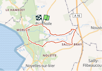
Tour Nordic Walking von 11,9 km verfügbar auf Nordfrankreich, Somme, Ponthoile. Diese Tour wird von denissculier vorgeschlagen.
Beschreibung
Vous aimerez le retour au point de départ : une aire de pique-nique au cœur du village avec un petit café encore ouvert !Une balade dans la petite vallée de deux rivières, le Dien et les Iles, alimentant un marais envié par de nombreux huttiers.
Ort
Land:
France
Region :
Nordfrankreich
Abteilung/Provinz :
Somme
Kommune :
Ponthoile
Standort:
Unknown
Gehen Sie:(Dec)
Gehen Sie:(UTM)
407992 ; 5563337 (31U) N.
Kommentare
Touren in der Umgebung
![Tour Wandern Saint-Valery-sur-Somme - Balade à Saint-Valery sur Somme - Photo](https://media.geolcdn.com/t/375/260/ext.jpg?maxdim=2&url=https%3A%2F%2Fservices.sitytrail.com%2FGeolivesWS%2FDownloadMedia.ashx%3FTrailID%3D108607%26Media%3D1515_1.jpg)
![Wandern Wandern](https://static1.geolcdn.com/sitytour/trail-icons/101.png)
Balade à Saint-Valery sur Somme
Wandern
Medium
(3)
Saint-Valery-sur-Somme,
Nordfrankreich,
Somme,
France
![](/images/other/stat-length.png)
7,1 km | 8,6 km-effort
2h 19min
![](https://static1.geolcdn.com/siteimages/upload/files/16400158638029165_repeat_loop_refresh_sync_direction_icon.png)
Ja
![Tour Wandern Favières - Circuit de Morlay - Photo](https://media.geolcdn.com/t/375/260/ext.jpg?maxdim=2&url=https%3A%2F%2Fservices.sitytrail.com%2FGeolivesWS%2FDownloadMedia.ashx%3FTrailID%3D108602%26Media%3D1510_1.jpg)
![Wandern Wandern](https://static1.geolcdn.com/sitytour/trail-icons/101.png)
Circuit de Morlay
Wandern
Schwierig
(1)
Favières,
Nordfrankreich,
Somme,
France
![](/images/other/stat-length.png)
12,4 km | 12,8 km-effort
4h 0min
![](https://static1.geolcdn.com/siteimages/upload/files/16400158638029165_repeat_loop_refresh_sync_direction_icon.png)
Ja
![Tour Wandern Saint-Valery-sur-Somme - Traversée Baie de Somme 11/08/2021 - Photo](https://media.geolcdn.com/t/375/260/486a482e-6345-45f3-b041-b66bc4ab348e.jpg&format=jpg&maxdim=2)
![Wandern Wandern](https://static1.geolcdn.com/sitytour/trail-icons/101.png)
Traversée Baie de Somme 11/08/2021
Wandern
Medium
Saint-Valery-sur-Somme,
Nordfrankreich,
Somme,
France
![](/images/other/stat-length.png)
8,5 km | 8,8 km-effort
2h 0min
![](https://static1.geolcdn.com/siteimages/upload/files/16400158638029165_repeat_loop_refresh_sync_direction_icon.png)
Nein
![Tour Mountainbike Saint-Valery-sur-Somme - Gravelot Baie de sommes - Photo](https://media.geolcdn.com/t/375/260/ext.jpg?maxdim=2&url=https%3A%2F%2Fstatic1.geolcdn.com%2Fsiteimages%2Fupload%2Ffiles%2F1524743154velo.jpg)
![Mountainbike Mountainbike](https://static1.geolcdn.com/sitytour/trail-icons/202.png)
Gravelot Baie de sommes
Mountainbike
Einfach
(1)
Saint-Valery-sur-Somme,
Nordfrankreich,
Somme,
France
![](/images/other/stat-length.png)
44 km | 47 km-effort
4h 56min
![](https://static1.geolcdn.com/siteimages/upload/files/16400158638029165_repeat_loop_refresh_sync_direction_icon.png)
Ja
![Tour Zu Fuß Favières - Circuit de Morlay - Photo](https://media.geolcdn.com/t/375/260/dc4913a2-fa6d-46cb-8850-5cbb3d809a42.jpeg&format=jpg&maxdim=2)
![Zu Fuß Zu Fuß](https://static1.geolcdn.com/sitytour/trail-icons/100.png)
Circuit de Morlay
Zu Fuß
Einfach
(1)
Favières,
Nordfrankreich,
Somme,
France
![](/images/other/stat-length.png)
10,8 km | 11,2 km-effort
2h 32min
![](https://static1.geolcdn.com/siteimages/upload/files/16400158638029165_repeat_loop_refresh_sync_direction_icon.png)
Nein
![Tour Zu Fuß Noyelles-sur-Mer - Les 400 Coups - Photo](https://media.geolcdn.com/t/375/260/aa4d9ebf-e9fe-4f2b-ba2c-89926fd96b21.jpeg&format=jpg&maxdim=2)
![Zu Fuß Zu Fuß](https://static1.geolcdn.com/sitytour/trail-icons/100.png)
Les 400 Coups
Zu Fuß
Einfach
Noyelles-sur-Mer,
Nordfrankreich,
Somme,
France
![](/images/other/stat-length.png)
11,8 km | 12,5 km-effort
2h 50min
![](https://static1.geolcdn.com/siteimages/upload/files/16400158638029165_repeat_loop_refresh_sync_direction_icon.png)
Ja
![Tour Mountainbike Ponthoile - ST-VALERY ... par la très belle chapelle de Hamelet. - Photo](https://media.geolcdn.com/t/375/260/271c1741-c2ea-46b9-87b7-0918fae3152e.jpg&format=jpg&maxdim=2)
![Mountainbike Mountainbike](https://static1.geolcdn.com/sitytour/trail-icons/202.png)
ST-VALERY ... par la très belle chapelle de Hamelet.
Mountainbike
Sehr leicht
Ponthoile,
Nordfrankreich,
Somme,
France
![](/images/other/stat-length.png)
18,9 km | 19,6 km-effort
1h 49min
![](https://static1.geolcdn.com/siteimages/upload/files/16400158638029165_repeat_loop_refresh_sync_direction_icon.png)
Ja
![Tour Zu Fuß Boismont - St-VALERY ... la Pointe du Hourdel. - Photo](https://media.geolcdn.com/t/375/260/ba83a63e-941e-41e2-b56e-c4e20995517b.jpg&format=jpg&maxdim=2)
![Zu Fuß Zu Fuß](https://static1.geolcdn.com/sitytour/trail-icons/100.png)
St-VALERY ... la Pointe du Hourdel.
Zu Fuß
Medium
Boismont,
Nordfrankreich,
Somme,
France
![](/images/other/stat-length.png)
23 km | 24 km-effort
5h 31min
![](https://static1.geolcdn.com/siteimages/upload/files/16400158638029165_repeat_loop_refresh_sync_direction_icon.png)
Ja
![Tour Wandern Favières - LP80_HAMLET-MORLAY_9,6Km - Photo](https://media.geolcdn.com/t/375/260/a6a34585-99df-4b8f-88a4-9490118b99dd.jpg&format=jpg&maxdim=2)
![Wandern Wandern](https://static1.geolcdn.com/sitytour/trail-icons/101.png)
LP80_HAMLET-MORLAY_9,6Km
Wandern
Medium
Favières,
Nordfrankreich,
Somme,
France
![](/images/other/stat-length.png)
9,6 km | 10 km-effort
2h 14min
![](https://static1.geolcdn.com/siteimages/upload/files/16400158638029165_repeat_loop_refresh_sync_direction_icon.png)
Ja