![](/images/other/stat-length.png)
![Tour Wandern Contamine-Sarzin - Contamine Sarzin Cascade Barbannaz - Photo](https://media.geolcdn.com/t/1900/400/0f28b968-81b1-4165-bc35-0aa8952e88f5.jpg&format=pjpeg&maxdim=2)
Contamine Sarzin Cascade Barbannaz
Petitchaperonvert
Benutzer
![Länge](/images/other/stat-length.png)
![Maximale Höhe](https://static1.geolcdn.com/siteimages/upload/files/1508320355ic_sort_altitude_max_24dp.png)
![Positive Höhendifferenz](https://static1.geolcdn.com/siteimages/upload/files/1508320355ic_sort_den_pos_24dp.png)
![Km-Effort](/images/other/stat-length.png)
![Min. Höhe](https://static1.geolcdn.com/siteimages/upload/files/1508320355ic_sort_altitude_min_24dp.png)
![Negative Höhendifferenz](https://static1.geolcdn.com/siteimages/upload/files/1508320355ic_sort_den_neg_24dp.png)
![Boucle](https://static1.geolcdn.com/siteimages/upload/files/16400158638029165_repeat_loop_refresh_sync_direction_icon.png)
![Wandern](https://static1.geolcdn.com/sitytour/trail-icons/101.png)
2h49
Schwierigkeit : Medium
![Scannen Sie diesen QR-Code, um die Tour in der SityTrail-Anwendung zu öffnen](https://capi.geolives.com/qq0zvz2zws4bq2lad0pu/sitytour/trails/2107509/qr.png?size=200)
Kostenlosegpshiking-Anwendung
Über SityTrail
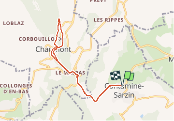
Tour Wandern von 8,6 km verfügbar auf Auvergne-Rhone-Alpen, Hochsavoyen, Contamine-Sarzin. Diese Tour wird von Petitchaperonvert vorgeschlagen.
Beschreibung
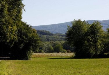
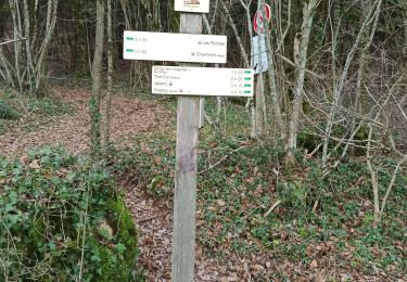
Départ : Se stationner à proximité de l'église de Contamine Sarzin. Ce village a beaucoup de charme et est bien entretenu. Idem pour Chaumont. L'itinéraire suit en partie le fléchage du chemin de St-Jacques de Compostelle.
Quelques bonnes montées jusqu'au pied du Vuache. Le contournement du Vuache en direction de Cortagy est très agréable.
Le retour permettant de faire plus ou moins une boucle se fait sur un sentier étroit et peu entretenu avec un descente un peu scabreuse sur la fin. On peut tout à fait revenir par le même chemin qu'à l'aller.
Points d'intérêts :
Jolie cascade (Barbannaz) et ses marmites que l'on peut apercevoir du Pont piétonnier de Pissieu.
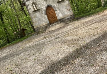
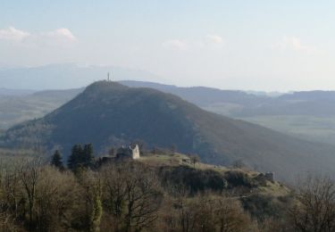
Ruines d'un château du 12ème siècle (édifié par les Comtes de Genève) que l'on peut apercevoir du joli bourg de Chaumont
Ort
Kommentare
Touren in der Umgebung
![Tour Wandern Musièges - Musiège - Photo](https://media.geolcdn.com/t/375/260/871f8854-49af-4823-b359-55712dd59238.jpg&format=jpg&maxdim=2)
![Wandern Wandern](https://static1.geolcdn.com/sitytour/trail-icons/101.png)
Wandern
![](/images/other/stat-length.png)
![](https://static1.geolcdn.com/siteimages/upload/files/16400158638029165_repeat_loop_refresh_sync_direction_icon.png)
![Tour Wandern Marlioz - 22-03-2022 Marlioz - Les Usses - Photo](https://media.geolcdn.com/t/375/260/7f065cfe-1b1c-42fc-8d4c-5817b76d5787.jpg&format=jpg&maxdim=2)
![Wandern Wandern](https://static1.geolcdn.com/sitytour/trail-icons/101.png)
Wandern
![](/images/other/stat-length.png)
![](https://static1.geolcdn.com/siteimages/upload/files/16400158638029165_repeat_loop_refresh_sync_direction_icon.png)
![Tour Wandern Frangy - Sur les Pas des Huguenots - Frangy - Chancy - Photo](https://media.geolcdn.com/t/375/260/ext.jpg?maxdim=2&url=https%3A%2F%2Fservices.sitytrail.com%2FGeolivesWS%2FDownloadMedia.ashx%3FTrailID%3D129736%26Media%3D13276_5.jpg)
![Wandern Wandern](https://static1.geolcdn.com/sitytour/trail-icons/101.png)
Wandern
![](/images/other/stat-length.png)
![](https://static1.geolcdn.com/siteimages/upload/files/16400158638029165_repeat_loop_refresh_sync_direction_icon.png)
![Tour Wandern Chaumont - Chaumont - Photo](https://media.geolcdn.com/t/375/260/4c16e9e3-8611-46e7-ba3a-5816a805df4e.jpg&format=jpg&maxdim=2)
![Wandern Wandern](https://static1.geolcdn.com/sitytour/trail-icons/101.png)
Wandern
![](/images/other/stat-length.png)
![](https://static1.geolcdn.com/siteimages/upload/files/16400158638029165_repeat_loop_refresh_sync_direction_icon.png)
![Tour Wandern Frangy - De Frangy à Chaumont - Photo](https://media.geolcdn.com/t/375/260/ext.jpg?maxdim=2&url=https%3A%2F%2Fservices.sitytrail.com%2FGeolivesWS%2FDownloadMedia.ashx%3FTrailID%3D614270%26Media%3Dfix__20160812130008.jpg)
![Wandern Wandern](https://static1.geolcdn.com/sitytour/trail-icons/101.png)
Wandern
![](/images/other/stat-length.png)
![](https://static1.geolcdn.com/siteimages/upload/files/16400158638029165_repeat_loop_refresh_sync_direction_icon.png)
![Tour Wandern Chaumont - chaumond - Photo](https://media.geolcdn.com/t/375/260/ext.jpg?maxdim=2&url=https%3A%2F%2Fstatic1.geolcdn.com%2Fsiteimages%2Fupload%2Ffiles%2F1553511878bg_sport_marche.png)
![Wandern Wandern](https://static1.geolcdn.com/sitytour/trail-icons/101.png)
Wandern
![](/images/other/stat-length.png)
![](https://static1.geolcdn.com/siteimages/upload/files/16400158638029165_repeat_loop_refresh_sync_direction_icon.png)
![Tour Mountainbike Marlioz - Marlioz forêt - Photo](https://media.geolcdn.com/t/375/260/322e1842-0891-444a-abc8-b3001718da65.jpg&format=jpg&maxdim=2)
![Mountainbike Mountainbike](https://static1.geolcdn.com/sitytour/trail-icons/202.png)
Mountainbike
![](/images/other/stat-length.png)
![](https://static1.geolcdn.com/siteimages/upload/files/16400158638029165_repeat_loop_refresh_sync_direction_icon.png)
![Tour Wandern Chaumont - Le VUACHE boucle Est - Photo](https://media.geolcdn.com/t/375/260/1db1e865-5ecc-43c6-b030-ab49553dbc87.jpg&format=jpg&maxdim=2)
![Wandern Wandern](https://static1.geolcdn.com/sitytour/trail-icons/101.png)
Wandern
![](/images/other/stat-length.png)
![](https://static1.geolcdn.com/siteimages/upload/files/16400158638029165_repeat_loop_refresh_sync_direction_icon.png)
![Tour Wandern Chaumont - 2021-10-08 Le Vuache en boucle - Photo](https://media.geolcdn.com/t/375/260/ext.jpg?maxdim=2&url=https%3A%2F%2Fstatic1.geolcdn.com%2Fsiteimages%2Fupload%2Ffiles%2F1553511878bg_sport_marche.png)
![Wandern Wandern](https://static1.geolcdn.com/sitytour/trail-icons/101.png)
Wandern
![](/images/other/stat-length.png)
![](https://static1.geolcdn.com/siteimages/upload/files/16400158638029165_repeat_loop_refresh_sync_direction_icon.png)